Tenango del Aire elevation
Tenango del Aire (State of Mexico), Mexico elevation is 2384 meters and Tenango del Aire elevation in feet is 7822 ft above sea level [src 1]. Tenango del Aire is a populated place (feature code) with elevation that is 1070 meters (3510 ft) bigger than average city elevation in Mexico.
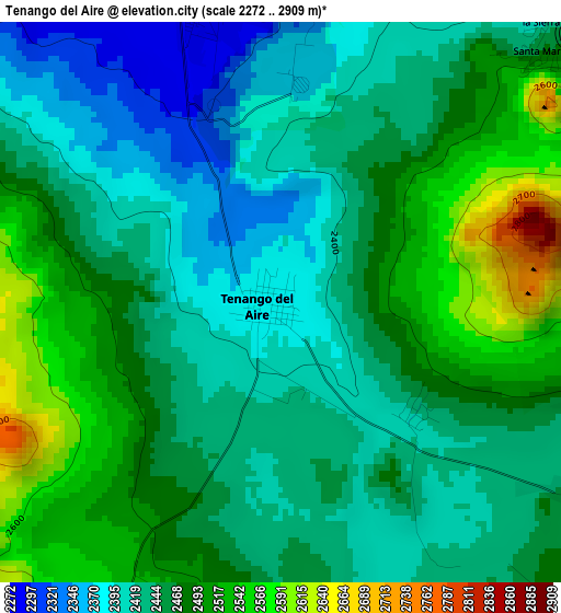
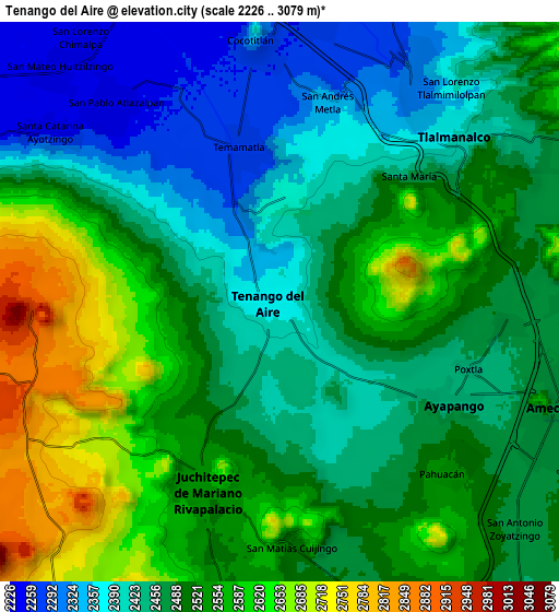
Below is the Elevation map of Tenango del Aire, which displays elevation range with different colors. Scale of the first map is from 2272 to 2909 m (7454 to 9544 ft) with average elevation of 2457.5 meters (=8063 ft) [note 1]
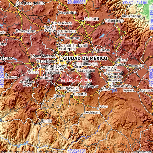
These maps also provides idea of topography and contour of this city, they are displayed at different zoom levels. More info about maps, scale and edge coordinates you can find below images.
| \ | Map #1 | Map #2 | Topo.Map |
| Scale [m] | 2272..2909 m | 2226..3079 m | × |
| Scale [ft] | 7454..9544 ft | 7303..10102 ft | × |
| Average | 2457.5 m = 8063 ft | 2493.7 m = 8181 ft | × |
| Width | 9.23 km = 5.7 mi | 18.46 km = 11.5 mi | 295.4 km = 183.6 mi |
| Height | 9.23 km = 5.7 mi | 18.46 km = 11.5 mi | 295.4 km = 183.6 mi |
| ↑Max Latitude | 19.199246° | 19.240742° | 20.48066° |
| Latitude at center | 19.15774° | 19.15774° | 19.15774° |
| ↓Min Latitude | 19.116223° | 19.074696° | 17.82413° |
| ← Min Longitude | -98.900815° | -98.944761° | -100.26312° |
| Longitude center | -98.85687° | -98.85687° | -98.85687° |
| →Max Longitude | -98.812925° | -98.768979° | -97.45062° |
Nearby cities:
Cities around Tenango del Aire sort by population:
• Juchitepec elevation 2535 m
6.8 km,  199°
199°
• Ayapango 2447 m
6.9 km,  119°
119°
• Temamatla 2278 m
5.2 km,  345°
345°
• Santiago Tepopula 2418 m
1.5 km,  180°
180°
• Zula 2259 m
7.7 km,  333°
333°
• San Juan Coxtocan 2434 m
2.3 km,  153°
153°
• Zentlalpan 2460 m
7.6 km,  96°
96°
• San Andrés Metla 2345 m
6.8 km,  13°
13°
• La Colonia 2457 m
7.5 km, 101°
• Los Reyes Acatlixhuayán 2267 m
6.3 km, 334°
• El Cabi 2362 m
3.6 km, 5°
• El Recodo de San José Axalco 2285 m
7 km,  316°
316°
Multilingual:
 En español:
Tenango del Aire elevación 2384 m.
 En France:
Tenango del Aire élévation 2384 m.
 Auf Deutsch:
Tenango del Aire höhe über dem Meeresspiegel ist 2384 m.

Sources and notes:
- [note 1] Map square and city borders are not equal. Map elevation data is calculated only from area inside that square.
- [src 1] Elevation data from geonames database provided with same terms of usage.
- [src 2] The elevation map of Tenango del Aire is generated using elevation data from NASA's 3 arcsec (90m) resolution SRTM data.
- [src 3] Base (background) map © OpenStreetMap contributors tiles are generated by Geofabrik and OpenTopoMap.
Copyright & License:
This Tenango del Aire Elevation Map is licensed under CC BY-SA. You may reuse any part from this page, if you give a proper credit by linking to this URL:
 More info on terms of use page.