Tepetitla elevation
Tepetitla (Tlaxcala, Tepetitla de Lardizábal), Mexico elevation is 2234 meters and Tepetitla elevation in feet is 7329 ft above sea level [src 1]. Tepetitla is a seat of a second-order administrative division (feature code) with elevation that is 920 meters (3018 ft) bigger than average city elevation in Mexico.
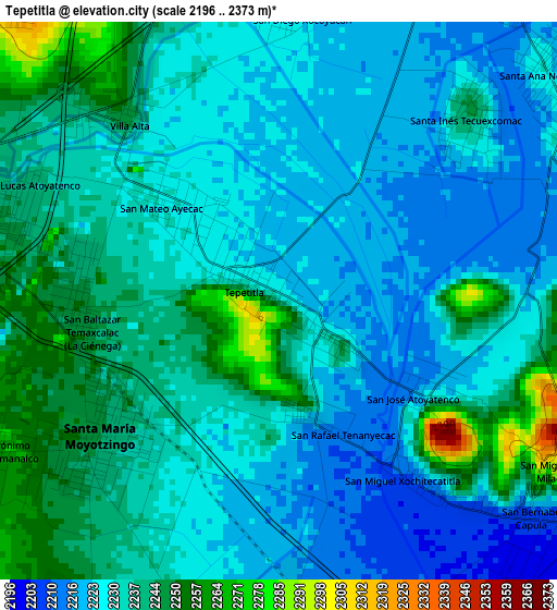
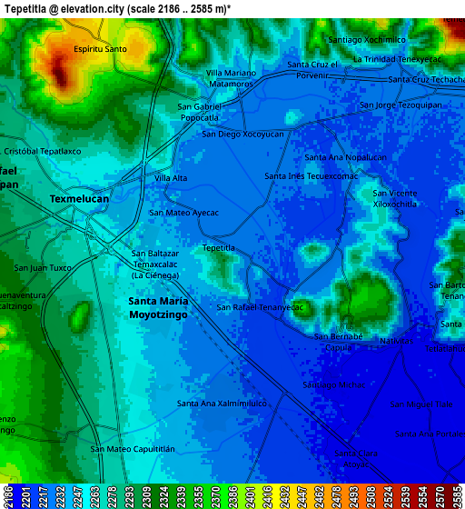
Below is the Elevation map of Tepetitla, which displays elevation range with different colors. Scale of the first map is from 2196 to 2373 m (7205 to 7785 ft) with average elevation of 2232.9 meters (=7326 ft) [note 1]
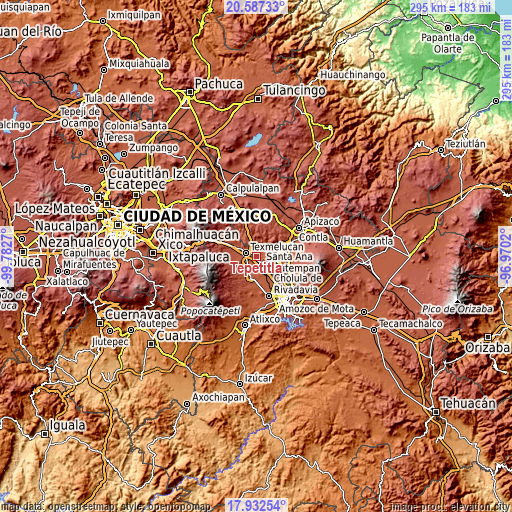
These maps also provides idea of topography and contour of this city, they are displayed at different zoom levels. More info about maps, scale and edge coordinates you can find below images.
| \ | Map #1 | Map #2 | Topo.Map |
| Scale [m] | 2196..2373 m | 2186..2585 m | × |
| Scale [ft] | 7205..7785 ft | 7172..8481 ft | × |
| Average | 2232.9 m = 7326 ft | 2258.5 m = 7410 ft | × |
| Width | 9.23 km = 5.7 mi | 18.45 km = 11.5 mi | 295.2 km = 183.4 mi |
| Height | 9.23 km = 5.7 mi | 18.45 km = 11.5 mi | 295.2 km = 183.4 mi |
| ↑Max Latitude | 19.306789° | 19.348258° | 20.58733° |
| Latitude at center | 19.26531° | 19.26531° | 19.26531° |
| ↓Min Latitude | 19.22382° | 19.18232° | 17.93254° |
| ← Min Longitude | -98.420395° | -98.464341° | -99.7827° |
| Longitude center | -98.37645° | -98.37645° | -98.37645° |
| →Max Longitude | -98.332505° | -98.288559° | -96.9702° |
Nearby cities:
Cities around Tepetitla sort by population:
• Moyotzingo elevation 2244 m
3.5 km,  237°
237°
• Santa Ana Nopalucan 2228 m
5.8 km,  51°
51°
• Villa Alta 2250 m
4 km,  319°
319°
• Tianguismanalco 2264 m
5.6 km, 241°
• Santa Justina Ecatepec 2252 m
5.5 km,  23°
23°
• Xocoyucan 2227 m
4.9 km,  2°
2°
• San Mateo Ayecac 2228 m
2.4 km,  308°
308°
• Santa Inés Tecuexcomac 2244 m
4.4 km,  44°
44°
• San Rafael Tenanyecac 2223 m
2 km,  164°
164°
• San Miguel Xochitecatitla 2219 m
3.8 km,  141°
141°
• San José Atoyatenco 2217 m
2.7 km,  125°
125°
• San Miguel del Milagro 2299 m
5.2 km,  120°
120°
Multilingual:
 En español:
Tepetitla, San Mateo elevación 2234 m.
 En France:
Tepetitla élévation 2234 m.
 Auf Deutsch:
Tepetitla höhe über dem Meeresspiegel ist 2234 m.

Sources and notes:
- [note 1] Map square and city borders are not equal. Map elevation data is calculated only from area inside that square.
- [src 1] Elevation data from geonames database provided with same terms of usage.
- [src 2] The elevation map of Tepetitla is generated using elevation data from NASA's 3 arcsec (90m) resolution SRTM data.
- [src 3] Base (background) map © OpenStreetMap contributors tiles are generated by Geofabrik and OpenTopoMap.
Copyright & License:
This Tepetitla Elevation Map is licensed under CC BY-SA. You may reuse any part from this page, if you give a proper credit by linking to this URL:
 More info on terms of use page.