Tlacotepec de Mejía elevation
Tlacotepec de Mejía (Veracruz), Mexico elevation is 903 meters and Tlacotepec de Mejía elevation in feet is 2963 ft above sea level [src 1]. Tlacotepec de Mejía is a seat of a second-order administrative division (feature code) with elevation that is 411 meters (1348 ft) smaller than average city elevation in Mexico.
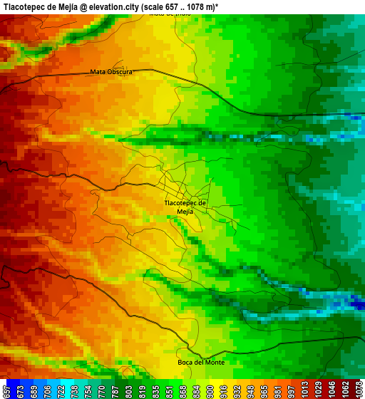
Below is the Elevation map of Tlacotepec de Mejía, which displays elevation range with different colors. Scale of the first map is from 657 to 1078 m (2156 to 3537 ft) with average elevation of 891.2 meters (=2924 ft) [note 1]
These maps also provides idea of topography and contour of this city, they are displayed at different zoom levels. More info about maps, scale and edge coordinates you can find below images.
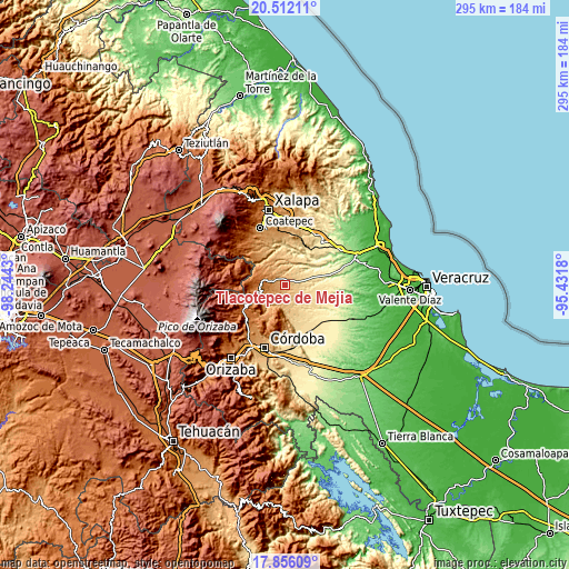
| \ | Map #1 | Topo.Map |
| Scale [m] | 657..1078 m | × |
| Scale [ft] | 2156..3537 ft | × |
| Average | 891.2 m = 2924 ft | × |
| Width | 9.23 km = 5.7 mi | 295.3 km = 183.5 mi |
| Height | 9.23 km = 5.7 mi | 295.3 km = 183.5 mi |
| ↑Max Latitude | 19.230958° | 20.51211° |
| Latitude at center | 19.18946° | 19.18946° |
| ↓Min Latitude | 19.147951° | 17.85609° |
| ← Min Longitude | -96.881995° | -98.2443° |
| Longitude center | -96.83805° | -96.83805° |
| →Max Longitude | -96.794105° | -95.4318° |
Nearby cities:
Cities around Tlacotepec de Mejía sort by population:
• Boca del Monte elevation 882 m
3.9 km,  171°
171°
• Totutla 1449 m
13.2 km,  280°
280°
• Tenampa 1021 m
8.2 km,  323°
323°
• Mata de Indio 902 m
4.6 km,  355°
355°
• Mata Obscura 950 m
3.6 km,  331°
331°
• Comapa 1066 m
5.8 km,  240°
240°
• Chavaxtla 841 m
6.6 km, 173°
• Tepatlaxco 833 m
13.4 km,  183°
183°
• Tlapala 1104 m
11.7 km,  313°
313°
• Coyolito 996 m
5.4 km, 321°
• Sochiapa 1340 m
10.7 km,  272°
272°
• Colonia Manuel González 946 m
8.6 km,  195°
195°
Multilingual:
 En español:
San Martín elevación 903 m.
 En France:
Tlacotepec de Mejía élévation 903 m.
 Auf Deutsch:
Tlacotepec de Mejía höhe über dem Meeresspiegel ist 903 m.
 На русском:
Tlacotepec de Mejía высота над уровнем моря 903 м
Sources and notes:
- [note 1] Map square and city borders are not equal. Map elevation data is calculated only from area inside that square.
- [src 1] Elevation data from geonames database provided with same terms of usage.
- [src 2] The elevation map of Tlacotepec de Mejía is generated using elevation data from NASA's 3 arcsec (90m) resolution SRTM data.
- [src 3] Base (background) map © OpenStreetMap contributors tiles are generated by Geofabrik and OpenTopoMap.
Copyright & License:
This Tlacotepec de Mejía Elevation Map is licensed under CC BY-SA. You may reuse any part from this page, if you give a proper credit by linking to this URL:
 More info on terms of use page.