Transfiguración elevation
Transfiguración (State of Mexico, Nicolás Romero), Mexico elevation is 2856 meters and Transfiguración elevation in feet is 9370 ft above sea level [src 1]. Transfiguración is a populated place (feature code) with elevation that is 1542 meters (5059 ft) bigger than average city elevation in Mexico.
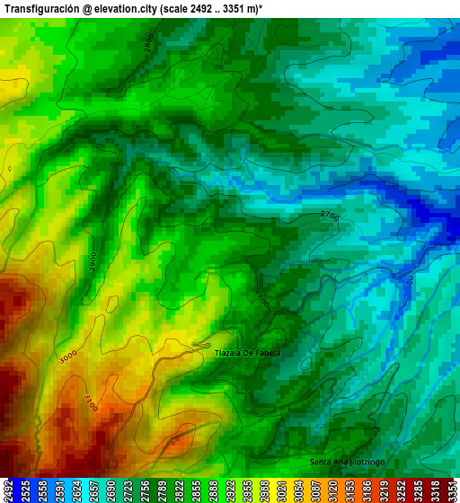
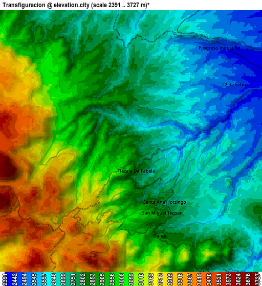
Below is the Elevation map of Transfiguración, which displays elevation range with different colors. Scale of the first map is from 2492 to 3351 m (8176 to 10994 ft) with average elevation of 2824 meters (=9265 ft) [note 1]
These maps also provides idea of topography and contour of this city, they are displayed at different zoom levels. More info about maps, scale and edge coordinates you can find below images.
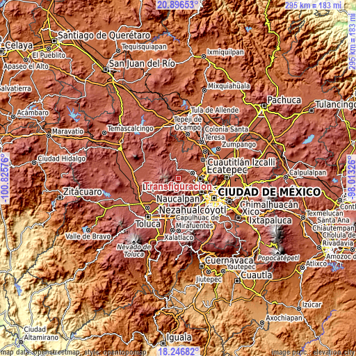
| \ | Map #1 | Map #2 | Topo.Map |
| Scale [m] | 2492..3351 m | 2391..3727 m | × |
| Scale [ft] | 8176..10994 ft | 7844..12228 ft | × |
| Average | 2824 m = 9265 ft | 2893.9 m = 9494 ft | × |
| Width | 9.21 km = 5.7 mi | 18.42 km = 11.4 mi | 294.6 km = 183.1 mi |
| Height | 9.21 km = 5.7 mi | 18.42 km = 11.4 mi | 294.6 km = 183.1 mi |
| ↑Max Latitude | 19.61852° | 19.659908° | 20.89653° |
| Latitude at center | 19.57712° | 19.57712° | 19.57712° |
| ↓Min Latitude | 19.53571° | 19.494289° | 18.24682° |
| ← Min Longitude | -99.463455° | -99.507401° | -100.82576° |
| Longitude center | -99.41951° | -99.41951° | -99.41951° |
| →Max Longitude | -99.375565° | -99.331619° | -98.01326° |
Nearby cities:
Cities around Transfiguración sort by population:
• Veintidós de Febrero elevation 2469 m
8.5 km,  63°
63°
• Quinto Barrio (Ejido Cahuacán) 2798 m
5 km,  1°
1°
• Santa María Magdalena Cahuacán 2741 m
6.8 km,  5°
5°
• San José el Vidrio 2623 m
9.2 km,  23°
23°
• Santa María Mazatla 2826 m
7.7 km,  153°
153°
• Tlazala de Fabela 2819 m
2.1 km,  166°
166°
• San Miguel Tecpan 2830 m
5.5 km,  155°
155°
• Colonia Palma 2977 m
1.5 km,  199°
199°
• Ejido Palma (Ejido San Francisco) 2775 m
1.4 km,  129°
129°
• Loma del Río 2469 m
7.7 km,  70°
70°
• Ejido Miraflores 2679 m
2.4 km,  108°
108°
• Santa Ana Jilotzingo 2767 m
4.8 km, 147°
Multilingual:
 En español:
Transfiguración elevación 2856 m.
 En France:
Transfiguración élévation 2856 m.
 Auf Deutsch:
Transfiguración höhe über dem Meeresspiegel ist 2856 m.

Sources and notes:
- [note 1] Map square and city borders are not equal. Map elevation data is calculated only from area inside that square.
- [src 1] Elevation data from geonames database provided with same terms of usage.
- [src 2] The elevation map of Transfiguración is generated using elevation data from NASA's 3 arcsec (90m) resolution SRTM data.
- [src 3] Base (background) map © OpenStreetMap contributors tiles are generated by Geofabrik and OpenTopoMap.
Copyright & License:
This Transfiguración Elevation Map is licensed under CC BY-SA. You may reuse any part from this page, if you give a proper credit by linking to this URL:
 More info on terms of use page.