Zacatepec elevation
Zacatepec (Puebla, Oriental), Mexico elevation is 2368 meters and Zacatepec elevation in feet is 7769 ft above sea level [src 1]. Zacatepec is a populated place (feature code) with elevation that is 1054 meters (3458 ft) bigger than average city elevation in Mexico.
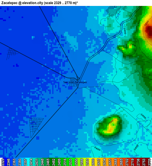
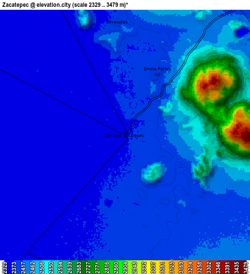
Below is the Elevation map of Zacatepec, which displays elevation range with different colors. Scale of the first map is from 2329 to 2770 m (7641 to 9088 ft) with average elevation of 2390.3 meters (=7842 ft) [note 1]
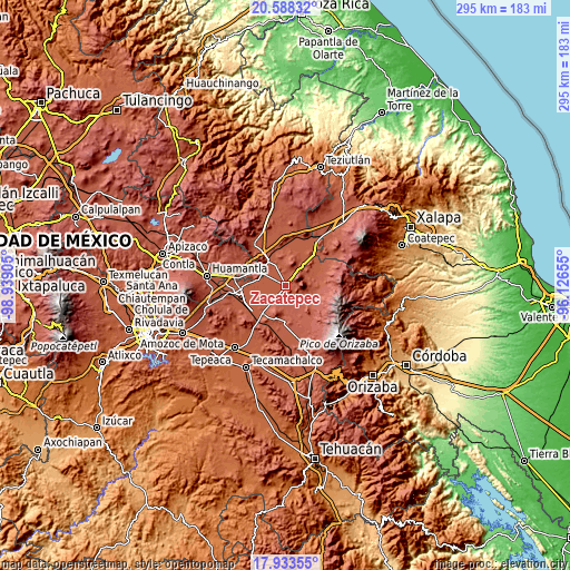
These maps also provides idea of topography and contour of this city, they are displayed at different zoom levels. More info about maps, scale and edge coordinates you can find below images.
| \ | Map #1 | Map #2 | Topo.Map |
| Scale [m] | 2329..2770 m | 2329..3479 m | × |
| Scale [ft] | 7641..9088 ft | 7641..11414 ft | × |
| Average | 2390.3 m = 7842 ft | 2430.4 m = 7974 ft | × |
| Width | 9.23 km = 5.7 mi | 18.45 km = 11.5 mi | 295.2 km = 183.4 mi |
| Height | 9.23 km = 5.7 mi | 18.45 km = 11.5 mi | 295.2 km = 183.4 mi |
| ↑Max Latitude | 19.307789° | 19.349257° | 20.58832° |
| Latitude at center | 19.26631° | 19.26631° | 19.26631° |
| ↓Min Latitude | 19.224821° | 19.183321° | 17.93355° |
| ← Min Longitude | -97.576745° | -97.620691° | -98.93905° |
| Longitude center | -97.5328° | -97.5328° | -97.5328° |
| →Max Longitude | -97.488855° | -97.444909° | -96.12655° |
Nearby cities:
Cities around Zacatepec sort by population:
• Villa de El Carmen Tequexquitla elevation 2363 m
14.2 km,  296°
296°
• Oriental 2354 m
15.3 km,  322°
322°
• San Nicolas Buenos Aires 2388 m
11.4 km,  189°
189°
• Emilio Portes Gil 2396 m
5.2 km,  27°
27°
• El Fuerte de la Unión 2341 m
18.5 km,  350°
350°
• Santa Cecilia Tepetitlán 2432 m
13.2 km,  128°
128°
• Guadalupe Libertad 2518 m
17.6 km,  119°
119°
• San Miguel Tecuitlapa 2430 m
16.2 km, 185°
• Álamos Tepetitlán 2427 m
12.6 km, 128°
• José María Morelos 2483 m
15.5 km,  153°
153°
• Miravalles 2392 m
8.4 km,  355°
355°
• Emancipación Quetzalapa 2551 m
18 km, 124°
Multilingual:
 En español:
Zacatepec elevación 2368 m.
 En France:
Zacatepec élévation 2368 m.
 Auf Deutsch:
Zacatepec höhe über dem Meeresspiegel ist 2368 m.

Sources and notes:
- [note 1] Map square and city borders are not equal. Map elevation data is calculated only from area inside that square.
- [src 1] Elevation data from geonames database provided with same terms of usage.
- [src 2] The elevation map of Zacatepec is generated using elevation data from NASA's 3 arcsec (90m) resolution SRTM data.
- [src 3] Base (background) map © OpenStreetMap contributors tiles are generated by Geofabrik and OpenTopoMap.
Copyright & License:
This Zacatepec Elevation Map is licensed under CC BY-SA. You may reuse any part from this page, if you give a proper credit by linking to this URL:
 More info on terms of use page.