Zapotlán de Juárez elevation
Zapotlán de Juárez (Hidalgo), Mexico elevation is 2380 meters and Zapotlán de Juárez elevation in feet is 7808 ft above sea level [src 1]. Zapotlán de Juárez is a seat of a second-order administrative division (feature code) with elevation that is 1066 meters (3497 ft) bigger than average city elevation in Mexico.
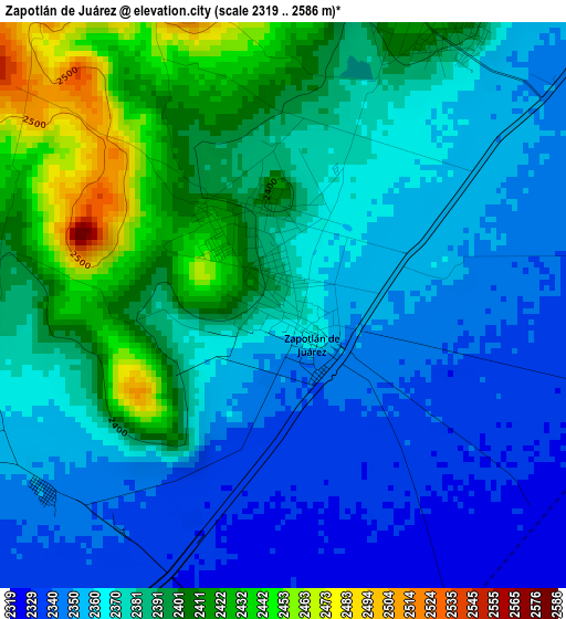
Below is the Elevation map of Zapotlán de Juárez, which displays elevation range with different colors. Scale of the first map is from 2319 to 2586 m (7608 to 8484 ft) with average elevation of 2376.3 meters (=7796 ft) [note 1]
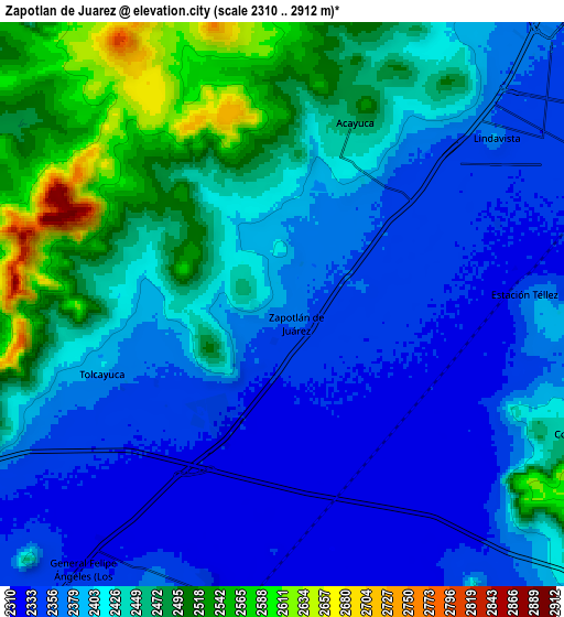
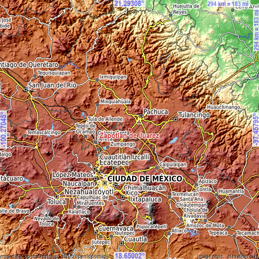
These maps also provides idea of topography and contour of this city, they are displayed at different zoom levels. More info about maps, scale and edge coordinates you can find below images.
| \ | Map #1 | Map #2 | Topo.Map |
| Scale [m] | 2319..2586 m | 2310..2912 m | × |
| Scale [ft] | 7608..8484 ft | 7579..9554 ft | × |
| Average | 2376.3 m = 7796 ft | 2414.7 m = 7922 ft | × |
| Width | 9.18 km = 5.7 mi | 18.37 km = 11.4 mi | 293.9 km = 182.6 mi |
| Height | 9.18 km = 5.7 mi | 18.37 km = 11.4 mi | 293.9 km = 182.6 mi |
| ↑Max Latitude | 20.018386° | 20.059671° | 21.29308° |
| Latitude at center | 19.97709° | 19.97709° | 19.97709° |
| ↓Min Latitude | 19.935783° | 19.894466° | 18.65002° |
| ← Min Longitude | -98.908145° | -98.952091° | -100.27045° |
| Longitude center | -98.8642° | -98.8642° | -98.8642° |
| →Max Longitude | -98.820255° | -98.776309° | -97.45795° |
Nearby cities:
Cities around Zapotlán de Juárez sort by population:
• Acayuca elevation 2447 m
5.9 km,  24°
24°
• Tolcayuca 2388 m
6.1 km,  249°
249°
• San Pedro Huaquilpan 2386 m
1.3 km,  343°
343°
• General Felipe Ángeles (Los Ángeles) 2342 m
11 km,  216°
216°
• Ixtlahuaca de Cuauhtémoc 2320 m
10.6 km,  177°
177°
• Jagüey de Téllez (Estación Téllez) 2362 m
7.9 km,  87°
87°
• Lindavista 2374 m
8.8 km,  51°
51°
• El Mirador 2379 m
8.1 km,  43°
43°
• Colonia Morelos 2330 m
10.8 km,  152°
152°
• Colonia Guadalupe 2477 m
11.1 km,  112°
112°
• Vicente Guerrero (San Javier) 2348 m
4.9 km,  232°
232°
• Las Pintas 2334 m
9.3 km,  194°
194°
Multilingual:
 En español:
Zapotlán de Juárez elevación 2380 m.
 En France:
Zapotlán de Juárez élévation 2380 m.
 Auf Deutsch:
Zapotlán de Juárez höhe über dem Meeresspiegel ist 2380 m.
 На русском:
Zapotlán de Juárez высота над уровнем моря 2380 м
Sources and notes:
- [note 1] Map square and city borders are not equal. Map elevation data is calculated only from area inside that square.
- [src 1] Elevation data from geonames database provided with same terms of usage.
- [src 2] The elevation map of Zapotlán de Juárez is generated using elevation data from NASA's 3 arcsec (90m) resolution SRTM data.
- [src 3] Base (background) map © OpenStreetMap contributors tiles are generated by Geofabrik and OpenTopoMap.
Copyright & License:
This Zapotlán de Juárez Elevation Map is licensed under CC BY-SA. You may reuse any part from this page, if you give a proper credit by linking to this URL:
 More info on terms of use page.