Zumpango del Río elevation
Zumpango del Río (Guerrero, Eduardo Neri), Mexico elevation is 1040 meters and Zumpango del Río elevation in feet is 3412 ft above sea level [src 1]. Zumpango del Río is a populated place (feature code) with elevation that is 274 meters (899 ft) smaller than average city elevation in Mexico.
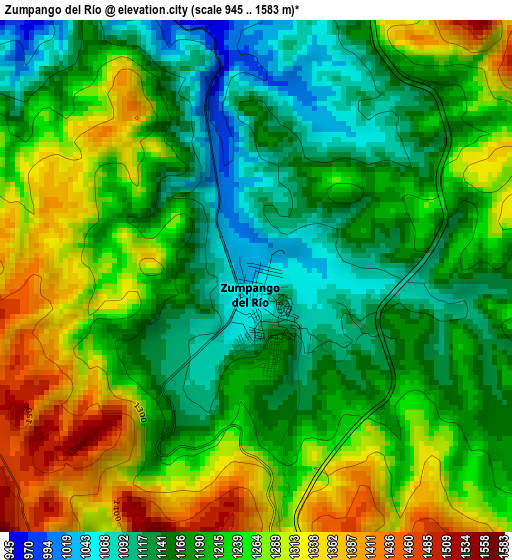
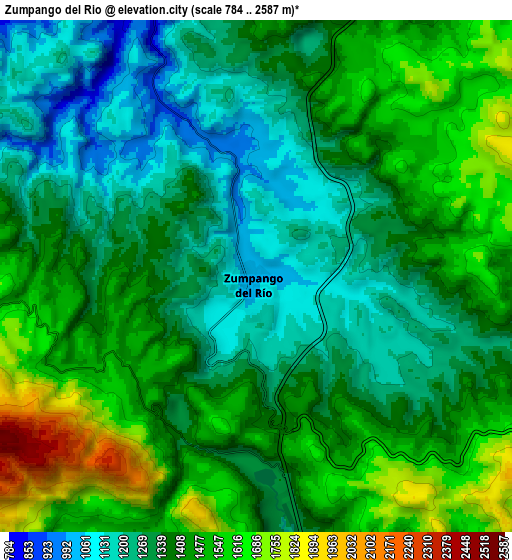
Below is the Elevation map of Zumpango del Río, which displays elevation range with different colors. Scale of the first map is from 945 to 1583 m (3100 to 5194 ft) with average elevation of 1216.5 meters (=3991 ft) [note 1]
These maps also provides idea of topography and contour of this city, they are displayed at different zoom levels. More info about maps, scale and edge coordinates you can find below images.
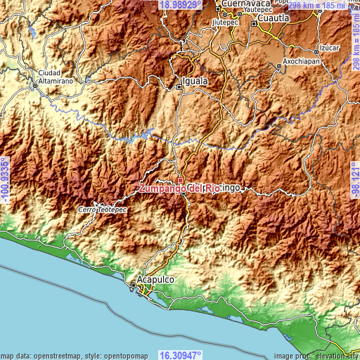
| \ | Map #1 | Map #2 | Topo.Map |
| Scale [m] | 945..1583 m | 784..2587 m | × |
| Scale [ft] | 3100..5194 ft | 2572..8488 ft | × |
| Average | 1216.5 m = 3991 ft | 1393.7 m = 4573 ft | × |
| Width | 9.31 km = 5.8 mi | 18.62 km = 11.6 mi | 298 km = 185.2 mi |
| Height | 9.31 km = 5.8 mi | 18.62 km = 11.6 mi | 298 km = 185.2 mi |
| ↑Max Latitude | 17.696241° | 17.738102° | 18.98929° |
| Latitude at center | 17.65437° | 17.65437° | 17.65437° |
| ↓Min Latitude | 17.612489° | 17.570599° | 16.30947° |
| ← Min Longitude | -99.571195° | -99.615141° | -100.9335° |
| Longitude center | -99.52725° | -99.52725° | -99.52725° |
| →Max Longitude | -99.483305° | -99.439359° | -98.121° |
Nearby cities:
Cities around Zumpango del Río sort by population:
• Chilpancingo elevation 1242 m
11.8 km,  168°
168°
• Tixtla de Guerrero 1354 m
16.8 km,  125°
125°
• Chichihualco 1148 m
15.8 km,  271°
271°
• Petaquillas 1153 m
20.1 km,  158°
158°
• Atliaca 1291 m
16.2 km,  91°
91°
• Huitziltepec 1318 m
12.4 km,  23°
23°
• Xochipala 1070 m
21.2 km,  325°
325°
• Acatempa 1287 m
17.1 km, 94°
• San Vicente 2160 m
22.8 km,  226°
226°
• Tepechicotlán 1042 m
22.4 km,  148°
148°
• Axaxacualco 1467 m
18 km, 22°
• Tlanipatla 1494 m
18.9 km,  25°
25°
Multilingual:
 En español:
Zumpango del Río elevación 1040 m.
 En France:
Zumpango del Río élévation 1040 m.
 Auf Deutsch:
Zumpango del Río höhe über dem Meeresspiegel ist 1040 m.
 На русском:
Зумпанго-дель-Рио высота над уровнем моря 1040 м
Sources and notes:
- [note 1] Map square and city borders are not equal. Map elevation data is calculated only from area inside that square.
- [src 1] Elevation data from geonames database provided with same terms of usage.
- [src 2] The elevation map of Zumpango del Río is generated using elevation data from NASA's 3 arcsec (90m) resolution SRTM data.
- [src 3] Base (background) map © OpenStreetMap contributors tiles are generated by Geofabrik and OpenTopoMap.
Copyright & License:
This Zumpango del Río Elevation Map is licensed under CC BY-SA. You may reuse any part from this page, if you give a proper credit by linking to this URL:
 More info on terms of use page.