San Fernando elevation
San Fernando (Tamaulipas), Mexico elevation is 44 meters and San Fernando elevation in feet is 144 ft above sea level [src 1]. San Fernando is a seat of a second-order administrative division (feature code) with elevation that is 1270 meters (4167 ft) smaller than average city elevation in Mexico.
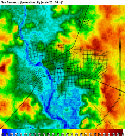
Below is the Elevation map of San Fernando, which displays elevation range with different colors. Scale of the first map is from 23 to 92 m (75 to 302 ft) with average elevation of 53 meters (=174 ft) [note 1]
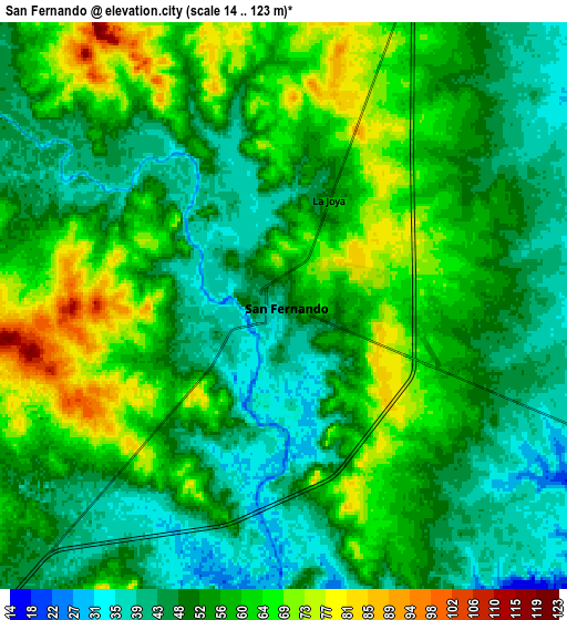
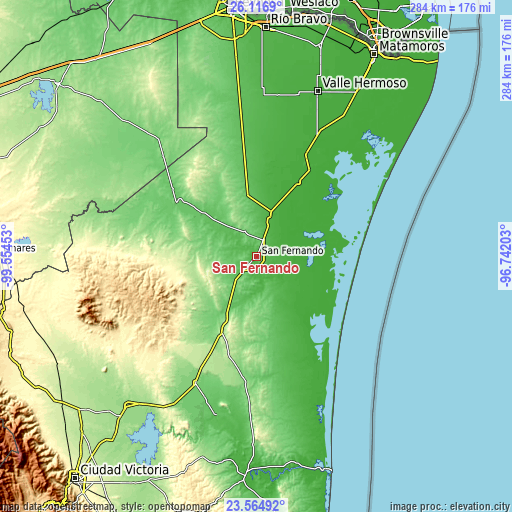
These maps also provides idea of topography and contour of this city, they are displayed at different zoom levels. More info about maps, scale and edge coordinates you can find below images.
| \ | Map #1 | Map #2 | Topo.Map |
| Scale [m] | 23..92 m | 14..123 m | × |
| Scale [ft] | 75..302 ft | 46..404 ft | × |
| Average | 53 m = 174 ft | 54.2 m = 178 ft | × |
| Width | 8.87 km = 5.5 mi | 17.74 km = 11 mi | 283.8 km = 176.3 mi |
| Height | 8.87 km = 5.5 mi | 17.74 km = 11 mi | 283.8 km = 176.3 mi |
| ↑Max Latitude | 24.887361° | 24.927219° | 26.1169° |
| Latitude at center | 24.84749° | 24.84749° | 24.84749° |
| ↓Min Latitude | 24.807606° | 24.76771° | 23.56492° |
| ← Min Longitude | -98.192225° | -98.236171° | -99.55453° |
| Longitude center | -98.14828° | -98.14828° | -98.14828° |
| →Max Longitude | -98.104335° | -98.060389° | -96.74203° |
Nearby cities:
Cities around San Fernando sort by population:
• Santander Jiménez elevation 113 m
77.9 km,  205°
205°
• Carboneras 3 m
49.9 km,  119°
119°
• Alfredo V. Bonfil 66 m
80 km,  353°
353°
• Las Higuerillas 2 m
85.3 km,  57°
57°
• Burgos 167 m
66.6 km,  279°
279°
• Alfredo V. Bonfil 16 m
44.7 km,  27°
27°
• San Germán 13 m
47 km, 29°
• San Carlos 453 m
85.4 km,  249°
249°
• El Barrancón del Tío Blas (El Barrancón) 6 m
47.3 km,  66°
66°
• Méndez 85 m
53.5 km,  304°
304°
• Cruillas 234 m
40.6 km,  255°
255°
• San Nicolás 691 m
70.9 km, 256°
Multilingual:
 En español:
San Fernando elevación 44 m.
 En France:
San Fernando élévation 44 m.
 Auf Deutsch:
San Fernando höhe über dem Meeresspiegel ist 44 m.

Sources and notes:
- [note 1] Map square and city borders are not equal. Map elevation data is calculated only from area inside that square.
- [src 1] Elevation data from geonames database provided with same terms of usage.
- [src 2] The elevation map of San Fernando is generated using elevation data from NASA's 3 arcsec (90m) resolution SRTM data.
- [src 3] Base (background) map © OpenStreetMap contributors tiles are generated by Geofabrik and OpenTopoMap.
Copyright & License:
This San Fernando Elevation Map is licensed under CC BY-SA. You may reuse any part from this page, if you give a proper credit by linking to this URL:
 More info on terms of use page.