Cuauhtémoc elevation
Cuauhtémoc (Tamaulipas, Altamira), Mexico elevation is 16 meters and Cuauhtémoc elevation in feet is 52 ft above sea level [src 1]. Cuauhtémoc is a populated place (feature code) with elevation that is 1298 meters (4259 ft) smaller than average city elevation in Mexico.
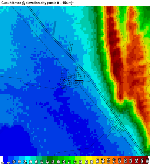
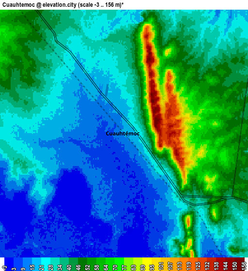
Below is the Elevation map of Cuauhtémoc, which displays elevation range with different colors. Scale of the first map is from 0 to 154 m (0 to 505 ft) with average elevation of 36.8 meters (=121 ft) [note 1]
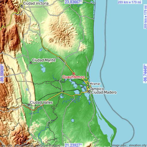
These maps also provides idea of topography and contour of this city, they are displayed at different zoom levels. More info about maps, scale and edge coordinates you can find below images.
| \ | Map #1 | Map #2 | Topo.Map |
| Scale [m] | 0..154 m | -3..156 m | × |
| Scale [ft] | 0..505 ft | -10..512 ft | × |
| Average | 36.8 m = 121 ft | 33.7 m = 111 ft | × |
| Width | 9.03 km = 5.6 mi | 18.05 km = 11.2 mi | 288.8 km = 179.5 mi |
| Height | 9.03 km = 5.6 mi | 18.05 km = 11.2 mi | 288.8 km = 179.5 mi |
| ↑Max Latitude | 22.584661° | 22.625231° | 23.83667° |
| Latitude at center | 22.54408° | 22.54408° | 22.54408° |
| ↓Min Latitude | 22.503487° | 22.462882° | 21.23927° |
| ← Min Longitude | -98.194685° | -98.238631° | -99.55699° |
| Longitude center | -98.15074° | -98.15074° | -98.15074° |
| →Max Longitude | -98.106795° | -98.062849° | -96.74449° |
Nearby cities:
Cities around Cuauhtémoc sort by population:
• Altamira elevation 14 m
27.6 km,  127°
127°
• Ursulo Galván 80 m
26.9 km,  319°
319°
• Carrillo Puerto 15 m
22.9 km,  123°
123°
• Esteros 26 m
3.7 km,  136°
136°
• López Rayón 30 m
32.2 km,  260°
260°
• Ricardo Flores Magón 8 m
27.1 km,  112°
112°
• Maclovio Herrera 57 m
8.3 km, 125°
• La Colonia 19 m
18 km, 130°
• San Antonio Rayón 23 m
30.6 km,  243°
243°
• Lomas del Real 16 m
26 km,  95°
95°
• Nuevo Cereso Regional de Altamira 29 m
17.3 km, 122°
• Unidos Avanzamos 17 m
22.1 km, 123°
Multilingual:
 En español:
Cuauhtémoc elevación 16 m.
 En France:
Cuauhtémoc élévation 16 m.
 Auf Deutsch:
Cuauhtémoc höhe über dem Meeresspiegel ist 16 m.

Sources and notes:
- [note 1] Map square and city borders are not equal. Map elevation data is calculated only from area inside that square.
- [src 1] Elevation data from geonames database provided with same terms of usage.
- [src 2] The elevation map of Cuauhtémoc is generated using elevation data from NASA's 3 arcsec (90m) resolution SRTM data.
- [src 3] Base (background) map © OpenStreetMap contributors tiles are generated by Geofabrik and OpenTopoMap.
Copyright & License:
This Cuauhtémoc Elevation Map is licensed under CC BY-SA. You may reuse any part from this page, if you give a proper credit by linking to this URL:
 More info on terms of use page.