Ntcheu elevation
Ntcheu (Central Region, Ntcheu District), Malawi elevation is 1132 meters and Ntcheu elevation in feet is 3714 ft above sea level [src 1]. Ntcheu is a seat of a second-order administrative division (feature code) with elevation that is 263 meters (863 ft) bigger than average city elevation in Malawi.
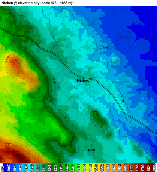
Below is the Elevation map of Ntcheu, which displays elevation range with different colors. Scale of the first map is from 973 to 1858 m (3192 to 6096 ft) with average elevation of 1200.6 meters (=3939 ft) [note 1]
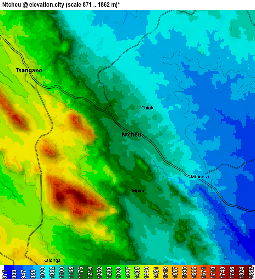
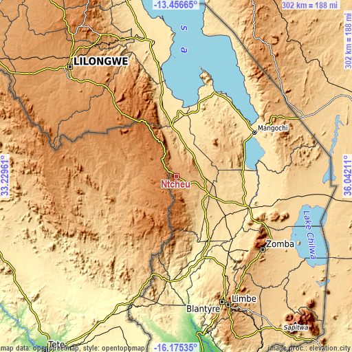
These maps also provides idea of topography and contour of this city, they are displayed at different zoom levels. More info about maps, scale and edge coordinates you can find below images.
| \ | Map #1 | Map #2 | Topo.Map |
| Scale [m] | 973..1858 m | 871..1862 m | × |
| Scale [ft] | 3192..6096 ft | 2858..6109 ft | × |
| Average | 1200.6 m = 3939 ft | 1186.2 m = 3892 ft | × |
| Width | 9.45 km = 5.9 mi | 18.89 km = 11.7 mi | 302.3 km = 187.8 mi |
| Height | 9.45 km = 5.9 mi | 18.89 km = 11.7 mi | 302.3 km = 187.8 mi |
| ↑Max Latitude | -14.777782° | -14.735287° | -13.45665° |
| Latitude at center | -14.82027° | -14.82027° | -14.82027° |
| ↓Min Latitude | -14.862749° | -14.90522° | -16.17535° |
| ← Min Longitude | 34.591915° | 34.547969° | 33.22961° |
| Longitude center | 34.63586° | 34.63586° | 34.63586° |
| →Max Longitude | 34.679805° | 34.723751° | 36.04211° |
Nearby cities:
Cities around Ntcheu sort by population:
• Blantyre elevation 1041 m
114.5 km,  159°
159°
• Zomba 949 m
96.6 km,  130°
130°
• Mangochi 484 m
77.6 km,  60°
60°
• Liwonde 499 m
69 km,  113°
113°
• Balaka 633 m
38.7 km,  117°
117°
• Dedza 1608 m
59 km,  326°
326°
• Monkey Bay 484 m
87.4 km,  20°
20°
• Mwanza 654 m
87.8 km,  187°
187°
• Chipoka 483 m
92.9 km,  351°
351°
• Chiradzulu 1118 m
109.3 km,  150°
150°
• Machinga 768 m
81.2 km, 118°
• Neno 907 m
64.3 km,  178°
178°
Multilingual:
 En español:
Ntcheu elevación 1132 m.
 En France:
Ntcheu élévation 1132 m.


Sources and notes:
- [note 1] Map square and city borders are not equal. Map elevation data is calculated only from area inside that square.
- [src 1] Elevation data from geonames database provided with same terms of usage.
- [src 2] The elevation map of Ntcheu is generated using elevation data from NASA's 3 arcsec (90m) resolution SRTM data.
- [src 3] Base (background) map © OpenStreetMap contributors tiles are generated by Geofabrik and OpenTopoMap.
Copyright & License:
This Ntcheu Elevation Map is licensed under CC BY-SA. You may reuse any part from this page, if you give a proper credit by linking to this URL:
 More info on terms of use page.