Monkey Bay elevation
Monkey Bay (Southern Region, Mangochi District), Malawi elevation is 484 meters and Monkey Bay elevation in feet is 1588 ft above sea level [src 1]. Monkey Bay is a populated place (feature code) with elevation that is 385 meters (1263 ft) smaller than average city elevation in Malawi.
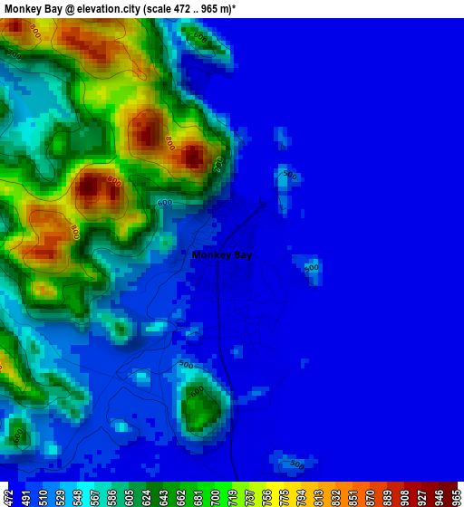
Below is the Elevation map of Monkey Bay, which displays elevation range with different colors. Scale of the first map is from 472 to 965 m (1549 to 3166 ft) with average elevation of 544.8 meters (=1787 ft) [note 1]
These maps also provides idea of topography and contour of this city, they are displayed at different zoom levels. More info about maps, scale and edge coordinates you can find below images.
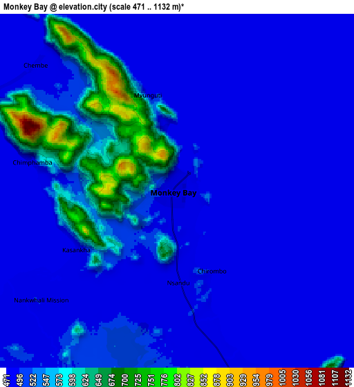
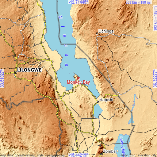
| \ | Map #1 | Map #2 | Topo.Map |
| Scale [m] | 472..965 m | 471..1132 m | × |
| Scale [ft] | 1549..3166 ft | 1545..3714 ft | × |
| Average | 544.8 m = 1787 ft | 517.2 m = 1697 ft | × |
| Width | 9.48 km = 5.9 mi | 18.96 km = 11.8 mi | 303.3 km = 188.5 mi |
| Height | 9.48 km = 5.9 mi | 18.96 km = 11.8 mi | 303.3 km = 188.5 mi |
| ↑Max Latitude | -14.039761° | -13.997125° | -12.71445° |
| Latitude at center | -14.08239° | -14.08239° | -14.08239° |
| ↓Min Latitude | -14.125011° | -14.167623° | -15.44219° |
| ← Min Longitude | 34.872575° | 34.828629° | 33.51027° |
| Longitude center | 34.91652° | 34.91652° | 34.91652° |
| →Max Longitude | 34.960465° | 35.004411° | 36.32277° |
Nearby cities:
Cities around Monkey Bay sort by population:
• Lilongwe elevation 1056 m
122.5 km,  276°
276°
• Mangochi 484 m
57.8 km,  139°
139°
• Salima 512 m
59.7 km,  304°
304°
• Liwonde 499 m
114.4 km,  163°
163°
• Balaka 633 m
99.8 km,  177°
177°
• Dedza 1608 m
70.9 km,  242°
242°
• Mponela 1216 m
141 km, 295°
• Ntcheu 1132 m
87.4 km,  200°
200°
• Ntchisi 1545 m
124.5 km, 299°
• Dowa 1361 m
115.9 km,  294°
294°
• Chipoka 483 m
44.4 km, 282°
• Machinga 768 m
127.6 km, 161°
Multilingual:
 En español:
Monkey Bay elevación 484 m.
 En France:
Monkey Bay élévation 484 m.
 Auf Deutsch:
Monkey Bay höhe über dem Meeresspiegel ist 484 m.

Sources and notes:
- [note 1] Map square and city borders are not equal. Map elevation data is calculated only from area inside that square.
- [src 1] Elevation data from geonames database provided with same terms of usage.
- [src 2] The elevation map of Monkey Bay is generated using elevation data from NASA's 3 arcsec (90m) resolution SRTM data.
- [src 3] Base (background) map © OpenStreetMap contributors tiles are generated by Geofabrik and OpenTopoMap.
Copyright & License:
This Monkey Bay Elevation Map is licensed under CC BY-SA. You may reuse any part from this page, if you give a proper credit by linking to this URL:
 More info on terms of use page.