Blantyre elevation
Blantyre (Southern Region, Blantyre District), Malawi elevation is 1041 meters and Blantyre elevation in feet is 3415 ft above sea level [src 1]. Blantyre is a seat of a first-order administrative division (feature code) with elevation that is 172 meters (564 ft) bigger than average city elevation in Malawi.
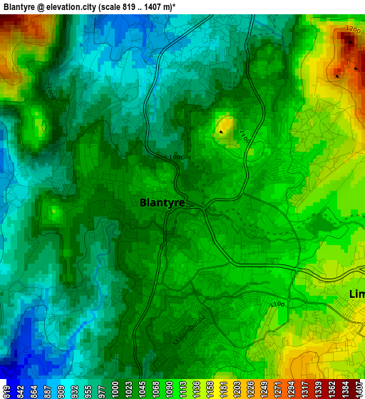
Below is the Elevation map of Blantyre, which displays elevation range with different colors. Scale of the first map is from 819 to 1407 m (2687 to 4616 ft) with average elevation of 1039.5 meters (=3410 ft) [note 1]
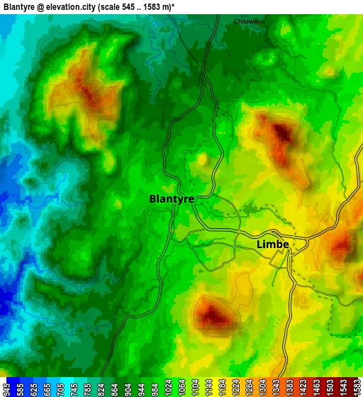
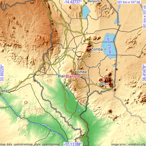
These maps also provides idea of topography and contour of this city, they are displayed at different zoom levels. More info about maps, scale and edge coordinates you can find below images.
| \ | Map #1 | Map #2 | Topo.Map |
| Scale [m] | 819..1407 m | 545..1583 m | × |
| Scale [ft] | 2687..4616 ft | 1788..5194 ft | × |
| Average | 1039.5 m = 3410 ft | 999.3 m = 3279 ft | × |
| Width | 9.4 km = 5.8 mi | 18.81 km = 11.7 mi | 300.9 km = 187 mi |
| Height | 9.4 km = 5.8 mi | 18.81 km = 11.7 mi | 300.9 km = 187 mi |
| ↑Max Latitude | -15.742697° | -15.700396° | -14.42737° |
| Latitude at center | -15.78499° | -15.78499° | -15.78499° |
| ↓Min Latitude | -15.827274° | -15.869549° | -17.13358° |
| ← Min Longitude | 34.964595° | 34.920649° | 33.60229° |
| Longitude center | 35.00854° | 35.00854° | 35.00854° |
| →Max Longitude | 35.052485° | 35.096431° | 36.41479° |
Nearby cities:
Cities around Blantyre sort by population:
• Zomba elevation 949 m
55.4 km,  36°
36°
• Liwonde 499 m
83.2 km,  16°
16°
• Mulanje 609 m
59.3 km,  117°
117°
• Luchenza 682 m
40.6 km,  127°
127°
• Mwanza 654 m
55.6 km,  291°
291°
• Chikwawa 106 m
35.4 km,  218°
218°
• Thyolo 912 m
34.5 km,  155°
155°
• Phalombe 766 m
68.7 km,  91°
91°
• Chiradzulu 1118 m
18.7 km,  49°
49°
• Machinga 768 m
75.3 km, 24°
• Neno 907 m
57.4 km,  318°
318°
• Makata 1085 m
2.4 km,  96°
96°
Multilingual:
 En español:
Blantyre elevación 1041 m.
 En France:
Blantyre élévation 1041 m.
 Auf Deutsch:
Blantyre höhe über dem Meeresspiegel ist 1041 m.

Sources and notes:
- [note 1] Map square and city borders are not equal. Map elevation data is calculated only from area inside that square.
- [src 1] Elevation data from geonames database provided with same terms of usage.
- [src 2] The elevation map of Blantyre is generated using elevation data from NASA's 3 arcsec (90m) resolution SRTM data.
- [src 3] Base (background) map © OpenStreetMap contributors tiles are generated by Geofabrik and OpenTopoMap.
Copyright & License:
This Blantyre Elevation Map is licensed under CC BY-SA. You may reuse any part from this page, if you give a proper credit by linking to this URL:
 More info on terms of use page.