Crève Coeur elevation
Crève Coeur (Pamplemousses), Mauritius elevation is 467 meters and Crève Coeur elevation in feet is 1532 ft above sea level [src 1]. Crève Coeur is a populated place (feature code) with elevation that is 318 meters (1043 ft) bigger than average city elevation in Mauritius.
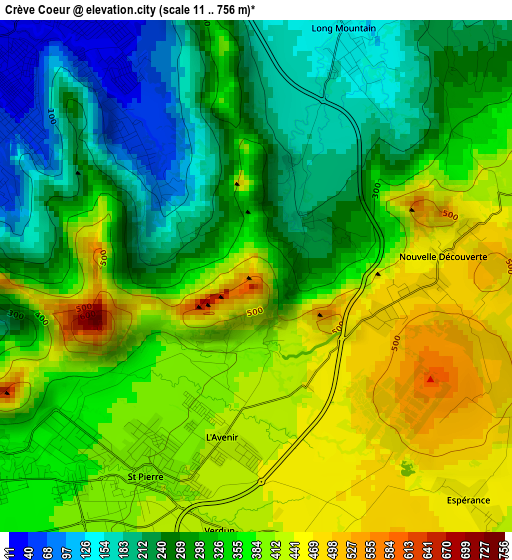
Below is the Elevation map of Crève Coeur, which displays elevation range with different colors. Scale of the first map is from 11 to 756 m (36 to 2480 ft) with average elevation of 334.3 meters (=1097 ft) [note 1]
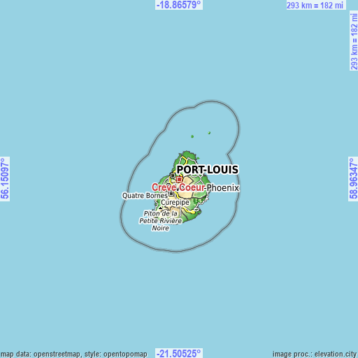
These maps also provides idea of topography and contour of this city, they are displayed at different zoom levels. More info about maps, scale and edge coordinates you can find below images.
| \ | Map #1 | Topo.Map |
| Scale [m] | 11..756 m | × |
| Scale [ft] | 36..2480 ft | × |
| Average | 334.3 m = 1097 ft | × |
| Width | 9.17 km = 5.7 mi | 293.5 km = 182.4 mi |
| Height | 9.17 km = 5.7 mi | 293.5 km = 182.4 mi |
| ↑Max Latitude | -20.14986° | -18.86579° |
| Latitude at center | -20.19111° | -20.19111° |
| ↓Min Latitude | -20.232349° | -21.50525° |
| ← Min Longitude | 57.513275° | 56.15097° |
| Longitude center | 57.55722° | 57.55722° |
| →Max Longitude | 57.601165° | 58.96347° |
Nearby cities:
Cities around Crève Coeur sort by population:
• Port Louis elevation 3 m
6.9 km,  298°
298°
• Saint Pierre 369 m
4.8 km,  232°
232°
• Le Hochet 30 m
7.3 km,  328°
328°
• Pailles 73 m
7.2 km,  268°
268°
• Moka 322 m
7.1 km,  244°
244°
• Long Mountain 134 m
5.4 km,  5°
5°
• Dagotière 446 m
6 km,  175°
175°
• Quartier Militaire 418 m
7.6 km,  146°
146°
• Notre Dame 111 m
5.6 km,  355°
355°
• Camp Thorel 392 m
6.7 km,  113°
113°
• Verdun 433 m
4.8 km, 183°
• Congomah 199 m
5.9 km,  36°
36°
Multilingual:
 En español:
Crève Coeur elevación 467 m.
 En France:
Crève Coeur élévation 467 m.
 Auf Deutsch:
Crève Coeur höhe über dem Meeresspiegel ist 467 m.

Sources and notes:
- [note 1] Map square and city borders are not equal. Map elevation data is calculated only from area inside that square.
- [src 1] Elevation data from geonames database provided with same terms of usage.
- [src 2] The elevation map of Crève Coeur is generated using elevation data from NASA's 3 arcsec (90m) resolution SRTM data.
- [src 3] Base (background) map © OpenStreetMap contributors tiles are generated by Geofabrik and OpenTopoMap.
Copyright & License:
This Crève Coeur Elevation Map is licensed under CC BY-SA. You may reuse any part from this page, if you give a proper credit by linking to this URL:
 More info on terms of use page.