Long Mountain elevation
Long Mountain (Pamplemousses), Mauritius elevation is 134 meters and Long Mountain elevation in feet is 440 ft above sea level [src 1]. Long Mountain is a populated place (feature code) with elevation that is 15 meters (49 ft) smaller than average city elevation in Mauritius.
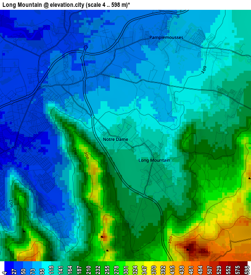
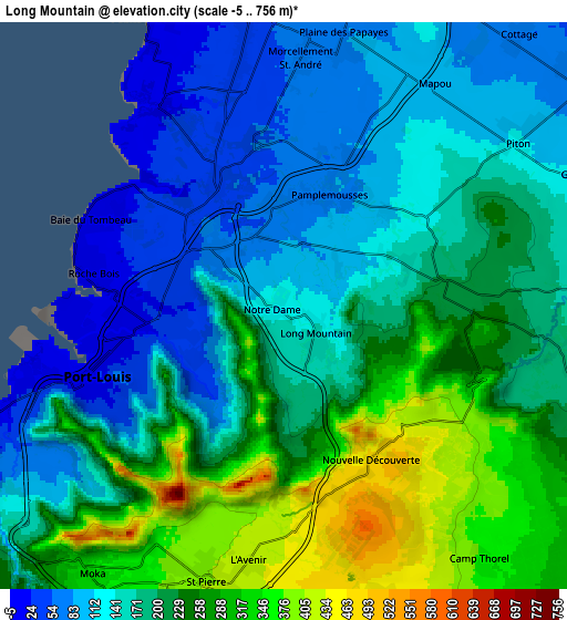
Below is the Elevation map of Long Mountain, which displays elevation range with different colors. Scale of the first map is from 4 to 598 m (13 to 1962 ft) with average elevation of 143.7 meters (=471 ft) [note 1]
These maps also provides idea of topography and contour of this city, they are displayed at different zoom levels. More info about maps, scale and edge coordinates you can find below images.
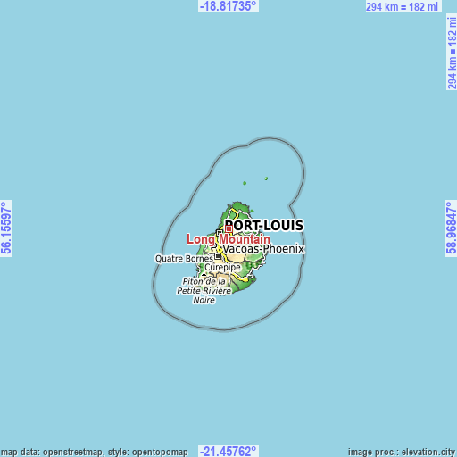
| \ | Map #1 | Map #2 | Topo.Map |
| Scale [m] | 4..598 m | -5..756 m | × |
| Scale [ft] | 13..1962 ft | -16..2480 ft | × |
| Average | 143.7 m = 471 ft | 193.9 m = 636 ft | × |
| Width | 9.17 km = 5.7 mi | 18.35 km = 11.4 mi | 293.6 km = 182.4 mi |
| Height | 9.17 km = 5.7 mi | 18.35 km = 11.4 mi | 293.6 km = 182.4 mi |
| ↑Max Latitude | -20.101797° | -20.060523° | -18.81735° |
| Latitude at center | -20.14306° | -20.14306° | -20.14306° |
| ↓Min Latitude | -20.184312° | -20.225553° | -21.45762° |
| ← Min Longitude | 57.518275° | 57.474329° | 56.15597° |
| Longitude center | 57.56222° | 57.56222° | 57.56222° |
| →Max Longitude | 57.606165° | 57.650111° | 58.96847° |
Nearby cities:
Cities around Long Mountain sort by population:
• Port Louis elevation 3 m
6.9 km,  252°
252°
• Le Hochet 30 m
4.4 km,  281°
281°
• Terre Rouge 40 m
4.4 km,  295°
295°
• Pamplemousses 64 m
4.4 km,  10°
10°
• Plaine des Papayes 68 m
8.7 km, 7°
• Morcellement Saint André 147 m
7.9 km,  4°
4°
• Calebasses 55 m
3.6 km,  346°
346°
• Notre Dame 111 m
1 km,  286°
286°
• Crève Coeur 467 m
5.4 km,  185°
185°
• Arsenal 40 m
5 km,  325°
325°
• Congomah 199 m
3.1 km,  102°
102°
• Mapou 91 m
8.5 km,  28°
28°
Multilingual:
 En español:
Long Mountain elevación 134 m.
 En France:
Long Mountain élévation 134 m.
 Auf Deutsch:
Long Mountain höhe über dem Meeresspiegel ist 134 m.

Sources and notes:
- [note 1] Map square and city borders are not equal. Map elevation data is calculated only from area inside that square.
- [src 1] Elevation data from geonames database provided with same terms of usage.
- [src 2] The elevation map of Long Mountain is generated using elevation data from NASA's 3 arcsec (90m) resolution SRTM data.
- [src 3] Base (background) map © OpenStreetMap contributors tiles are generated by Geofabrik and OpenTopoMap.
Copyright & License:
This Long Mountain Elevation Map is licensed under CC BY-SA. You may reuse any part from this page, if you give a proper credit by linking to this URL:
 More info on terms of use page.