Altay sumu elevation
Altay sumu (Hovd), Mongolia elevation is 1307 meters and Altay sumu elevation in feet is 4288 ft above sea level [src 1]. Altay sumu is a seat of a second-order administrative division (feature code) with elevation that is 106 meters (348 ft) smaller than average city elevation in Mongolia.
Below is the Elevation map of Altay sumu, which displays elevation range with different colors. Scale of the first map is from 1289 to 1486 m (4229 to 4875 ft) with average elevation of 1329.8 meters (=4363 ft) [note 1]
These maps also provides idea of topography and contour of this city, they are displayed at different zoom levels. More info about maps, scale and edge coordinates you can find below images.
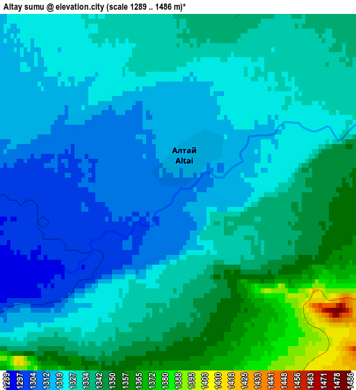
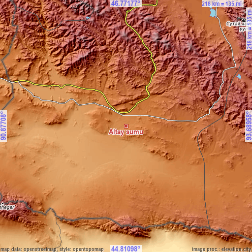
| \ | Map #1 | Topo.Map |
| Scale [m] | 1289..1486 m | × |
| Scale [ft] | 4229..4875 ft | × |
| Average | 1329.8 m = 4363 ft | × |
| Width | 6.81 km = 4.2 mi | 218 km = 135.5 mi |
| Height | 6.81 km = 4.2 mi | 218 km = 135.5 mi |
| ↑Max Latitude | 45.830629° | 46.77177° |
| Latitude at center | 45.8° | 45.8° |
| ↓Min Latitude | 45.769354° | 44.81098° |
| ← Min Longitude | 92.239385° | 90.87708° |
| Longitude center | 92.28333° | 92.28333° |
| →Max Longitude | 92.327275° | 93.68958° |
Nearby cities:
Cities around Altay sumu sort by population:
• Tögrög elevation 1350 m
180.6 km,  358°
358°
• Bayangol 2136 m
163.9 km,  99°
99°
• Darvi 1471 m
162.6 km,  38°
38°
• Darvi 1643 m
158.7 km,  62°
62°
• Jargalant 1929 m
155.3 km,  323°
323°
• Altanteel 1142 m
151.9 km,  16°
16°
• Dzüyl 2206 m
137.2 km,  65°
65°
• Tsenher 2800 m
124.8 km,  354°
354°
• Tsetsegnuur 1709 m
116.8 km, 40°
• Ulaantolgoy 2033 m
105.5 km, 21°
• Bürenhayrhan 1183 m
65.5 km,  299°
299°
• Uyenchi Somon 1378 m
34.6 km, 323°
Multilingual:
 En español:
Altay sumu elevación 1307 m.
 En France:
Altay sumu élévation 1307 m.
 Auf Deutsch:
Altay sumu höhe über dem Meeresspiegel ist 1307 m.

Sources and notes:
- [note 1] Map square and city borders are not equal. Map elevation data is calculated only from area inside that square.
- [src 1] Elevation data from geonames database provided with same terms of usage.
- [src 2] The elevation map of Altay sumu is generated using elevation data from NASA's 3 arcsec (90m) resolution SRTM data.
- [src 3] Base (background) map © OpenStreetMap contributors tiles are generated by Geofabrik and OpenTopoMap.
Copyright & License:
This Altay sumu Elevation Map is licensed under CC BY-SA. You may reuse any part from this page, if you give a proper credit by linking to this URL:
 More info on terms of use page.