Tögrög elevation
Tögrög (Hovd), Mongolia elevation is 1350 meters and Tögrög elevation in feet is 4429 ft above sea level [src 1]. Tögrög is a seat of a second-order administrative division (feature code) with elevation that is 63 meters (207 ft) smaller than average city elevation in Mongolia.
Below is the Elevation map of Tögrög, which displays elevation range with different colors. Scale of the first map is from 1289 to 1849 m (4229 to 6066 ft) with average elevation of 1392.4 meters (=4568 ft) [note 1]
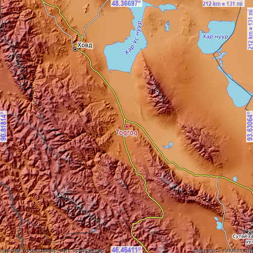
These maps also provides idea of topography and contour of this city, they are displayed at different zoom levels. More info about maps, scale and edge coordinates you can find below images.
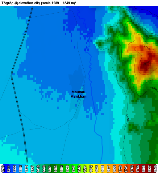
| \ | Map #1 | Topo.Map |
| Scale [m] | 1289..1849 m | × |
| Scale [ft] | 4229..6066 ft | × |
| Average | 1392.4 m = 4568 ft | × |
| Width | 6.61 km = 4.1 mi | 211.6 km = 131.5 mi |
| Height | 6.61 km = 4.1 mi | 211.6 km = 131.5 mi |
| ↑Max Latitude | 47.453863° | 48.36697° |
| Latitude at center | 47.42414° | 47.42414° |
| ↓Min Latitude | 47.3944° | 46.46411° |
| ← Min Longitude | 92.180445° | 90.81814° |
| Longitude center | 92.22439° | 92.22439° |
| →Max Longitude | 92.268335° | 93.63064° |
Nearby cities:
Cities around Tögrög sort by population:
• Khovd elevation 1395 m
78 km,  326°
326°
• Tsetsegnuur 1709 m
121 km,  139°
139°
• Darvi 1471 m
118.4 km,  117°
117°
• Rashaant 2052 m
111 km,  290°
290°
• Jargalant 1929 m
102.2 km,  237°
237°
• Bayanhoshuu 1176 m
92.9 km,  345°
345°
• Ulaantolgoy 2033 m
92.6 km,  152°
152°
• Buyant 1232 m
77.7 km,  336°
336°
• Altanteel 1142 m
58.3 km,  126°
126°
• Tsenher 2800 m
57 km,  188°
188°
• Urdgol 1520 m
55.6 km,  35°
35°
• Duut 2297 m
45.6 km,  283°
283°
Multilingual:
 En español:
Tögrög elevación 1350 m.
 En France:
Tögrög élévation 1350 m.


Sources and notes:
- [note 1] Map square and city borders are not equal. Map elevation data is calculated only from area inside that square.
- [src 1] Elevation data from geonames database provided with same terms of usage.
- [src 2] The elevation map of Tögrög is generated using elevation data from NASA's 3 arcsec (90m) resolution SRTM data.
- [src 3] Base (background) map © OpenStreetMap contributors tiles are generated by Geofabrik and OpenTopoMap.
Copyright & License:
This Tögrög Elevation Map is licensed under CC BY-SA. You may reuse any part from this page, if you give a proper credit by linking to this URL:
 More info on terms of use page.