Darvi elevation
Darvi (Govĭ-Altay), Mongolia elevation is 1643 meters and Darvi elevation in feet is 5390 ft above sea level [src 1]. Darvi is a seat of a second-order administrative division (feature code) with elevation that is 230 meters (755 ft) bigger than average city elevation in Mongolia.
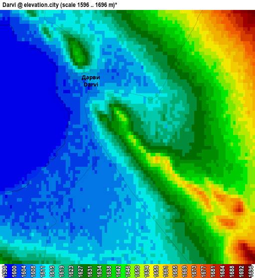
Below is the Elevation map of Darvi, which displays elevation range with different colors. Scale of the first map is from 1596 to 1696 m (5236 to 5564 ft) with average elevation of 1622.5 meters (=5323 ft) [note 1]
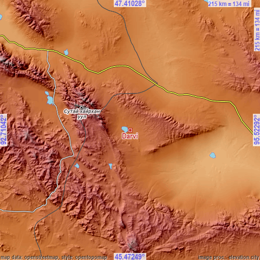
These maps also provides idea of topography and contour of this city, they are displayed at different zoom levels. More info about maps, scale and edge coordinates you can find below images.
| \ | Map #1 | Topo.Map |
| Scale [m] | 1596..1696 m | × |
| Scale [ft] | 5236..5564 ft | × |
| Average | 1622.5 m = 5323 ft | × |
| Width | 6.73 km = 4.2 mi | 215.5 km = 133.9 mi |
| Height | 6.73 km = 4.2 mi | 215.4 km = 133.8 mi |
| ↑Max Latitude | 46.480269° | 47.41028° |
| Latitude at center | 46.45° | 46.45° |
| ↓Min Latitude | 46.419714° | 45.47249° |
| ← Min Longitude | 94.072725° | 92.71042° |
| Longitude center | 94.11667° | 94.11667° |
| →Max Longitude | 94.160615° | 95.52292° |
Nearby cities:
Cities around Darvi sort by population:
• Buyanbat elevation 1538 m
149.9 km,  66°
66°
• Buga 1396 m
149.3 km,  26°
26°
• Altanteel 1142 m
121.6 km,  307°
307°
• Sayn-Ust 1448 m
105.5 km,  17°
17°
• Ulaantolgoy 2033 m
105.2 km,  284°
284°
• Bayan 1848 m
102.3 km,  53°
53°
• Bayangol 2136 m
101.2 km,  169°
169°
• Sharga 998 m
91 km,  104°
104°
• Tögrög 1676 m
87.5 km,  142°
142°
• Tsetsegnuur 1709 m
67.1 km, 284°
• Darvi 1471 m
66.2 km,  324°
324°
• Dzüyl 2206 m
22.8 km,  225°
225°
Multilingual:
 En español:
Darvi elevación 1643 m.
 En France:
Darvi élévation 1643 m.


Sources and notes:
- [note 1] Map square and city borders are not equal. Map elevation data is calculated only from area inside that square.
- [src 1] Elevation data from geonames database provided with same terms of usage.
- [src 2] The elevation map of Darvi is generated using elevation data from NASA's 3 arcsec (90m) resolution SRTM data.
- [src 3] Base (background) map © OpenStreetMap contributors tiles are generated by Geofabrik and OpenTopoMap.
Copyright & License:
This Darvi Elevation Map is licensed under CC BY-SA. You may reuse any part from this page, if you give a proper credit by linking to this URL:
 More info on terms of use page.