Rostusa elevation
Rostusa (Mavrovo and Rostuša), North Macedonia elevation is 789 meters and Rostusa elevation in feet is 2589 ft above sea level [src 1]. Rostusa is a seat of a first-order administrative division (feature code) with elevation that is 290 meters (951 ft) bigger than average city elevation in North Macedonia.
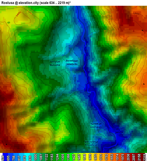
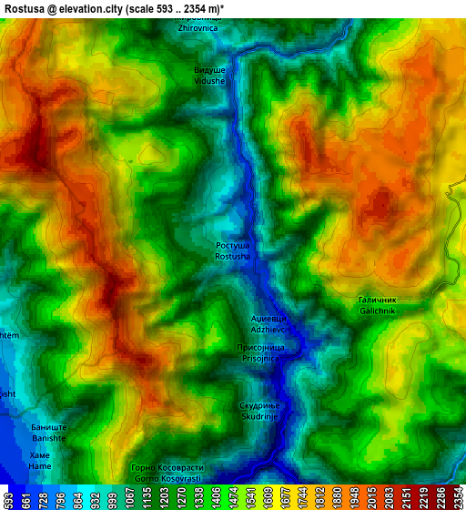
Below is the Elevation map of Rostusa, which displays elevation range with different colors. Scale of the first map is from 634 to 2219 m (2080 to 7280 ft) with average elevation of 1298.3 meters (=4260 ft) [note 1]
These maps also provides idea of topography and contour of this city, they are displayed at different zoom levels. More info about maps, scale and edge coordinates you can find below images.
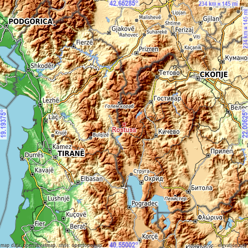
| \ | Map #1 | Map #2 | Topo.Map |
| Scale [m] | 634..2219 m | 593..2354 m | × |
| Scale [ft] | 2080..7280 ft | 1946..7723 ft | × |
| Average | 1298.3 m = 4260 ft | 1417.1 m = 4649 ft | × |
| Width | 7.31 km = 4.5 mi | 14.61 km = 9.1 mi | 233.8 km = 145.3 mi |
| Height | 7.31 km = 4.5 mi | 14.61 km = 9.1 mi | 233.8 km = 145.3 mi |
| ↑Max Latitude | 41.642849° | 41.675681° | 42.65285° |
| Latitude at center | 41.61° | 41.61° | 41.61° |
| ↓Min Latitude | 41.577135° | 41.544252° | 40.55002° |
| ← Min Longitude | 20.556055° | 20.512109° | 19.19375° |
| Longitude center | 20.6° | 20.6° | 20.6° |
| →Max Longitude | 20.643945° | 20.687891° | 22.00625° |
Nearby cities:
Cities around Rostusa sort by population:
• Gostivar elevation 535 m
32.9 km,  51°
51°
• Centar Župa 738 m
15 km,  192°
192°
• Kičevo 615 m
31.8 km,  109°
109°
• Debar 655 m
11.4 km,  213°
213°
• Zajas 748 m
28.1 km,  90°
90°
• Dolna Banjica 540 m
32.1 km, 52°
• Vrapčište 571 m
34.4 km,  43°
43°
• Vrutok 677 m
26.6 km, 48°
• Srbinovo 655 m
31.6 km,  70°
70°
• Drugovo 632 m
30.5 km,  117°
117°
• Strelci 677 m
34.6 km,  102°
102°
• Lukovo 681 m
28.5 km,  178°
178°
Multilingual:
 En español:
Rostusa elevación 789 m.
 En France:
Rostoucha élévation 789 m.


Sources and notes:
- [note 1] Map square and city borders are not equal. Map elevation data is calculated only from area inside that square.
- [src 1] Elevation data from geonames database provided with same terms of usage.
- [src 2] The elevation map of Rostusa is generated using elevation data from NASA's 3 arcsec (90m) resolution SRTM data.
- [src 3] Base (background) map © OpenStreetMap contributors tiles are generated by Geofabrik and OpenTopoMap.
Copyright & License:
This Rostusa Elevation Map is licensed under CC BY-SA. You may reuse any part from this page, if you give a proper credit by linking to this URL:
 More info on terms of use page.