Hryhoriopol elevation
Hryhoriopol (Transnistria), Moldova elevation is 21 meters and Hryhoriopol elevation in feet is 69 ft above sea level [src 1]. Hryhoriopol is a populated place (feature code) with elevation that is 72 meters (236 ft) smaller than average city elevation in Moldova.
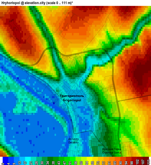
Below is the Elevation map of Hryhoriopol, which displays elevation range with different colors. Scale of the first map is from 0 to 111 m (0 to 364 ft) with average elevation of 50.5 meters (=166 ft) [note 1]
These maps also provides idea of topography and contour of this city, they are displayed at different zoom levels. More info about maps, scale and edge coordinates you can find below images.
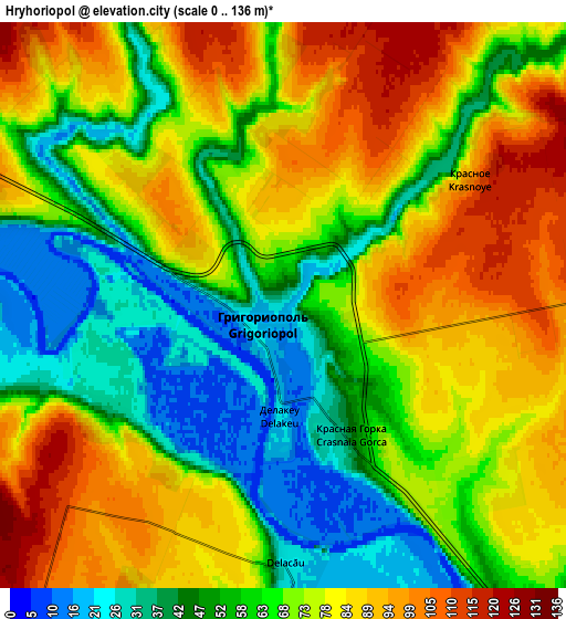
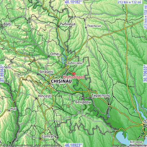
| \ | Map #1 | Map #2 | Topo.Map |
| Scale [m] | 0..111 m | 0..136 m | × |
| Scale [ft] | 0..364 ft | 0..446 ft | × |
| Average | 50.5 m = 166 ft | 68.8 m = 226 ft | × |
| Width | 6.65 km = 4.1 mi | 13.29 km = 8.3 mi | 212.7 km = 132.2 mi |
| Height | 6.65 km = 4.1 mi | 13.29 km = 8.3 mi | 212.6 km = 132.1 mi |
| ↑Max Latitude | 47.184006° | 47.213865° | 48.10182° |
| Latitude at center | 47.15413° | 47.15413° | 47.15413° |
| ↓Min Latitude | 47.124238° | 47.094328° | 46.18923° |
| ← Min Longitude | 29.256135° | 29.212189° | 27.89383° |
| Longitude center | 29.30008° | 29.30008° | 29.30008° |
| →Max Longitude | 29.344025° | 29.387971° | 30.70633° |
Nearby cities:
Cities around Hryhoriopol sort by population:
• Dubăsari elevation 39 m
16 km,  320°
320°
• Anenii Noi 28 m
31.1 km,  189°
189°
• Cricova 134 m
33.2 km,  266°
266°
• Sîngera 50 m
36.6 km,  223°
223°
• Criuleni 31 m
12.5 km,  301°
301°
• Ciorescu 105 m
31.2 km, 265°
• Stăuceni 188 m
33.3 km,  258°
258°
• Vadul lui Vodă 47 m
18.4 km,  247°
247°
• Cocieri 89 m
21.4 km, 319°
• Varniţa 94 m
34.4 km,  158°
158°
• Ustia 25 m
17.4 km,  310°
310°
• Maiac 161 m
11.3 km,  34°
34°
Multilingual:
 En español:
Hryhoriopol elevación 21 m.
 En France:
Hryhoriopol élévation 21 m.
 Auf Deutsch:
Hryhoriopol höhe über dem Meeresspiegel ist 21 m.

Sources and notes:
- [note 1] Map square and city borders are not equal. Map elevation data is calculated only from area inside that square.
- [src 1] Elevation data from geonames database provided with same terms of usage.
- [src 2] The elevation map of Hryhoriopol is generated using elevation data from NASA's 3 arcsec (90m) resolution SRTM data.
- [src 3] Base (background) map © OpenStreetMap contributors tiles are generated by Geofabrik and OpenTopoMap.
Copyright & License:
This Hryhoriopol Elevation Map is licensed under CC BY-SA. You may reuse any part from this page, if you give a proper credit by linking to this URL:
 More info on terms of use page.