Aïn Leuh elevation
Aïn Leuh (Fès-Meknès), Morocco elevation is 1424 meters and Aïn Leuh elevation in feet is 4672 ft above sea level [src 1]. Aïn Leuh is a populated place (feature code) with elevation that is 808 meters (2651 ft) bigger than average city elevation in Morocco.
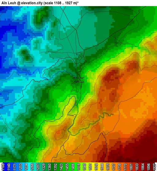
Below is the Elevation map of Aïn Leuh, which displays elevation range with different colors. Scale of the first map is from 1108 to 1927 m (3635 to 6322 ft) with average elevation of 1485.1 meters (=4872 ft) [note 1]
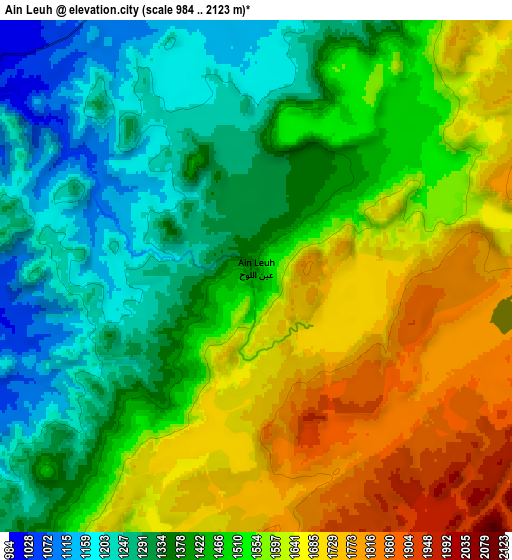
These maps also provides idea of topography and contour of this city, they are displayed at different zoom levels. More info about maps, scale and edge coordinates you can find below images.
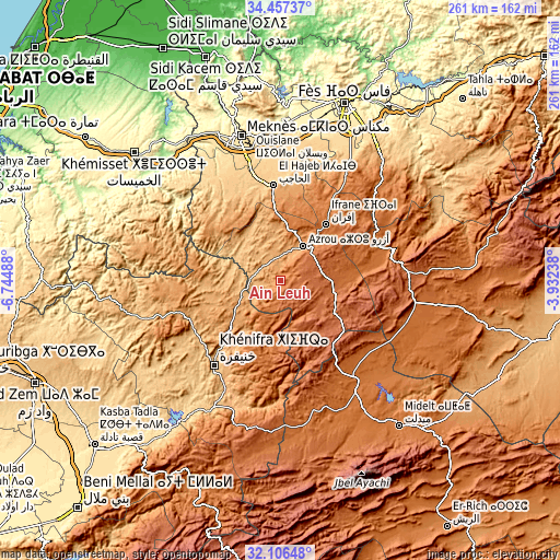
| \ | Map #1 | Map #2 | Topo.Map |
| Scale [m] | 1108..1927 m | 984..2123 m | × |
| Scale [ft] | 3635..6322 ft | 3228..6965 ft | × |
| Average | 1485.1 m = 4872 ft | 1488.9 m = 4885 ft | × |
| Width | 8.17 km = 5.1 mi | 16.34 km = 10.2 mi | 261.4 km = 162.4 mi |
| Height | 8.17 km = 5.1 mi | 16.34 km = 10.2 mi | 261.4 km = 162.4 mi |
| ↑Max Latitude | 33.326566° | 33.363277° | 34.45737° |
| Latitude at center | 33.28984° | 33.28984° | 33.28984° |
| ↓Min Latitude | 33.253098° | 33.216341° | 32.10648° |
| ← Min Longitude | -5.382575° | -5.426521° | -6.74488° |
| Longitude center | -5.33863° | -5.33863° | -5.33863° |
| →Max Longitude | -5.294685° | -5.250739° | -3.93238° |
Nearby cities:
Cities around Aïn Leuh sort by population:
• Meknès elevation 531 m
69.8 km,  343°
343°
• Khenifra 868 m
49.6 km,  217°
217°
• Ifrane 1648 m
33.8 km,  38°
38°
• Azrou 1277 m
19.4 km,  34°
34°
• El Hajeb 1023 m
44.4 km,  356°
356°
• Oulmes 1175 m
63.4 km,  283°
283°
• Boumia 1520 m
66.7 km,  160°
160°
• Sidi Amar 905 m
59.5 km,  230°
230°
• Boulemane 1712 m
57.2 km,  81°
81°
• Kerrouchen 1370 m
54.9 km,  178°
178°
• Itzer 1658 m
53 km,  149°
149°
• Aguelmous 1187 m
49.3 km,  253°
253°
Multilingual:
 En español:
Aïn Leuh elevación 1424 m.
 En France:
Aïn Leuh élévation 1424 m.
 Auf Deutsch:
Aïn Leuh höhe über dem Meeresspiegel ist 1424 m.

Sources and notes:
- [note 1] Map square and city borders are not equal. Map elevation data is calculated only from area inside that square.
- [src 1] Elevation data from geonames database provided with same terms of usage.
- [src 2] The elevation map of Aïn Leuh is generated using elevation data from NASA's 3 arcsec (90m) resolution SRTM data.
- [src 3] Base (background) map © OpenStreetMap contributors tiles are generated by Geofabrik and OpenTopoMap.
Copyright & License:
This Aïn Leuh Elevation Map is licensed under CC BY-SA. You may reuse any part from this page, if you give a proper credit by linking to this URL:
 More info on terms of use page.