Kelaat Mgouna elevation
Kelaat Mgouna (Drâa-Tafilalet, Tinghir Province), Morocco elevation is 1431 meters and Kelaat Mgouna elevation in feet is 4695 ft above sea level [src 1]. Kelaat Mgouna is a populated place (feature code) with elevation that is 815 meters (2674 ft) bigger than average city elevation in Morocco.
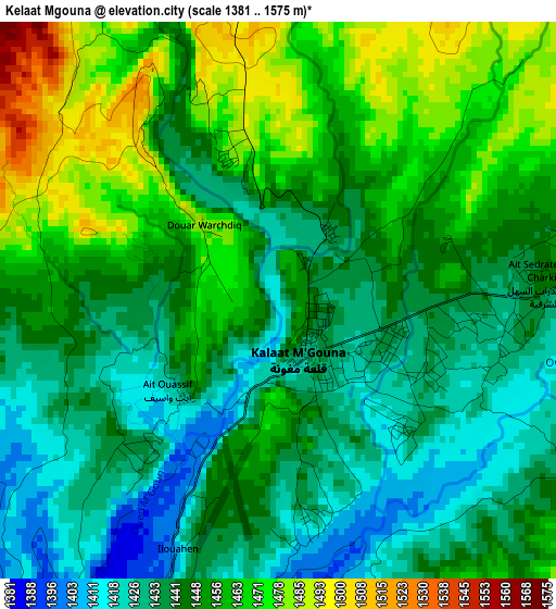
Below is the Elevation map of Kelaat Mgouna, which displays elevation range with different colors. Scale of the first map is from 1381 to 1575 m (4531 to 5167 ft) with average elevation of 1448.8 meters (=4753 ft) [note 1]
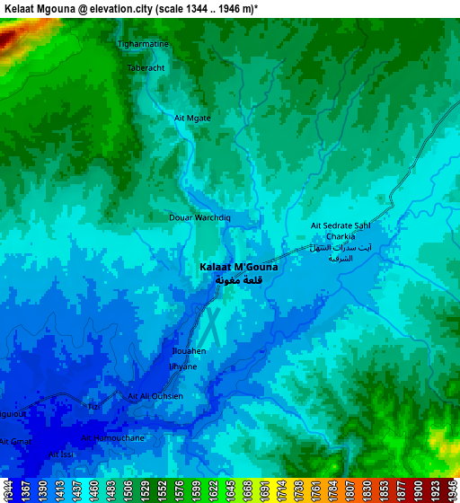
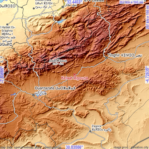
These maps also provides idea of topography and contour of this city, they are displayed at different zoom levels. More info about maps, scale and edge coordinates you can find below images.
| \ | Map #1 | Map #2 | Topo.Map |
| Scale [m] | 1381..1575 m | 1344..1946 m | × |
| Scale [ft] | 4531..5167 ft | 4409..6385 ft | × |
| Average | 1448.8 m = 4753 ft | 1474.4 m = 4837 ft | × |
| Width | 8.35 km = 5.2 mi | 16.71 km = 10.4 mi | 267.3 km = 166.1 mi |
| Height | 8.36 km = 5.2 mi | 16.71 km = 10.4 mi | 267.4 km = 166.2 mi |
| ↑Max Latitude | 31.283294° | 31.320842° | 32.4403° |
| Latitude at center | 31.24573° | 31.24573° | 31.24573° |
| ↓Min Latitude | 31.208151° | 31.170558° | 30.03586° |
| ← Min Longitude | -6.176545° | -6.220491° | -7.53885° |
| Longitude center | -6.1326° | -6.1326° | -6.1326° |
| →Max Longitude | -6.088655° | -6.044709° | -4.72635° |
Nearby cities:
Cities around Kelaat Mgouna sort by population:
• Ouarzazat elevation 1113 m
81 km,  243°
243°
• Tinghir 1281 m
64.3 km,  62°
62°
• Ifrane 2019 m
54.8 km,  337°
337°
• Alnif 871 m
92.6 km,  99°
99°
• Ouaoula 1237 m
90.8 km,  319°
319°
• Azilal 1357 m
89.8 km,  332°
332°
• Tifni 1417 m
87.7 km,  298°
298°
• Tilmi 2057 m
72.4 km,  28°
28°
• Agdz 940 m
68.3 km,  205°
205°
• Tabant 1972 m
52.4 km, 329°
• Skoura 1226 m
44.8 km, 242°
• Imider 1429 m
35.2 km,  66°
66°
Multilingual:
 En español:
Kelaat Mgouna elevación 1431 m.
 En France:
Kelaat Mgouna élévation 1431 m.
 Auf Deutsch:
Kelaat Mgouna höhe über dem Meeresspiegel ist 1431 m.

Sources and notes:
- [note 1] Map square and city borders are not equal. Map elevation data is calculated only from area inside that square.
- [src 1] Elevation data from geonames database provided with same terms of usage.
- [src 2] The elevation map of Kelaat Mgouna is generated using elevation data from NASA's 3 arcsec (90m) resolution SRTM data.
- [src 3] Base (background) map © OpenStreetMap contributors tiles are generated by Geofabrik and OpenTopoMap.
Copyright & License:
This Kelaat Mgouna Elevation Map is licensed under CC BY-SA. You may reuse any part from this page, if you give a proper credit by linking to this URL:
 More info on terms of use page.