Tinghir elevation
Tinghir (Drâa-Tafilalet, Tinghir Province), Morocco elevation is 1281 meters and Tinghir elevation in feet is 4203 ft above sea level [src 1]. Tinghir is a seat of a second-order administrative division (feature code) with elevation that is 665 meters (2182 ft) bigger than average city elevation in Morocco.
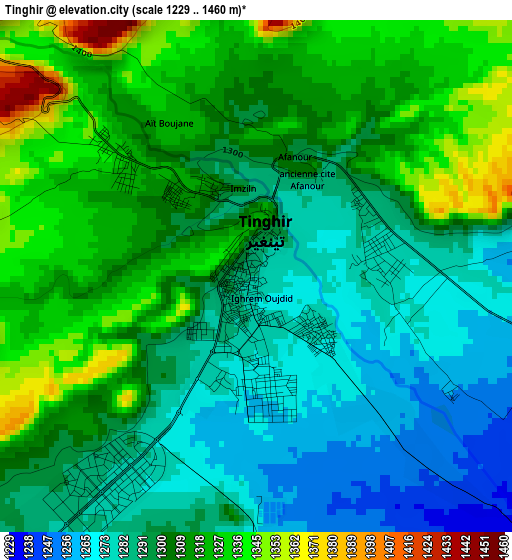
Below is the Elevation map of Tinghir, which displays elevation range with different colors. Scale of the first map is from 1229 to 1460 m (4032 to 4790 ft) with average elevation of 1302.8 meters (=4274 ft) [note 1]
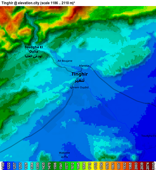
These maps also provides idea of topography and contour of this city, they are displayed at different zoom levels. More info about maps, scale and edge coordinates you can find below images.
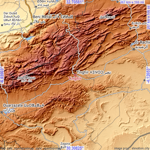
| \ | Map #1 | Map #2 | Topo.Map |
| Scale [m] | 1229..1460 m | 1186..2110 m | × |
| Scale [ft] | 4032..4790 ft | 3891..6923 ft | × |
| Average | 1302.8 m = 4274 ft | 1371.2 m = 4499 ft | × |
| Width | 8.33 km = 5.2 mi | 16.66 km = 10.4 mi | 266.6 km = 165.7 mi |
| Height | 8.33 km = 5.2 mi | 16.66 km = 10.4 mi | 266.6 km = 165.7 mi |
| ↑Max Latitude | 31.552176° | 31.589617° | 32.70581° |
| Latitude at center | 31.51472° | 31.51472° | 31.51472° |
| ↓Min Latitude | 31.477249° | 31.439763° | 30.30825° |
| ← Min Longitude | -5.576725° | -5.620671° | -6.93903° |
| Longitude center | -5.53278° | -5.53278° | -5.53278° |
| →Max Longitude | -5.488835° | -5.444889° | -4.12653° |
Nearby cities:
Cities around Tinghir sort by population:
• Kelaat Mgouna elevation 1431 m
64.3 km,  242°
242°
• Ifrane 2019 m
80.1 km,  285°
285°
• Jebel Tiskaouine 1025 m
67.1 km,  143°
143°
• Amouguer 1628 m
101.6 km,  33°
33°
• Tabant 1972 m
84.5 km,  280°
280°
• Anergui 1468 m
72.7 km,  328°
328°
• Imilchil 2162 m
71.5 km,  353°
353°
• Goulmima 1028 m
58.4 km,  70°
70°
• Assoul 1641 m
57.6 km, 32°
• Alnif 871 m
56.2 km, 142°
• Tilmi 2057 m
40.4 km, 326°
• Imider 1429 m
29.3 km, 237°
Multilingual:
 En español:
Tinghir elevación 1281 m.
 En France:
Tinghir élévation 1281 m.
 Auf Deutsch:
Tinerhir höhe über dem Meeresspiegel ist 1281 m.

Sources and notes:
- [note 1] Map square and city borders are not equal. Map elevation data is calculated only from area inside that square.
- [src 1] Elevation data from geonames database provided with same terms of usage.
- [src 2] The elevation map of Tinghir is generated using elevation data from NASA's 3 arcsec (90m) resolution SRTM data.
- [src 3] Base (background) map © OpenStreetMap contributors tiles are generated by Geofabrik and OpenTopoMap.
Copyright & License:
This Tinghir Elevation Map is licensed under CC BY-SA. You may reuse any part from this page, if you give a proper credit by linking to this URL:
 More info on terms of use page.