Limbaži elevation
Limbaži (Limbažu novads), Latvia elevation is 78 meters and Limbaži elevation in feet is 256 ft above sea level [src 1]. Limbaži is a seat of a first-order administrative division (feature code) with elevation that is 12 meters (39 ft) bigger than average city elevation in Latvia.
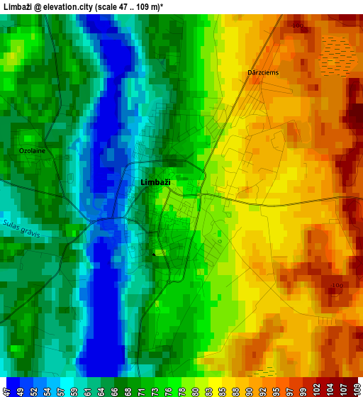
Below is the Elevation map of Limbaži, which displays elevation range with different colors. Scale of the first map is from 47 to 109 m (154 to 358 ft) with average elevation of 75.3 meters (=247 ft) [note 1]
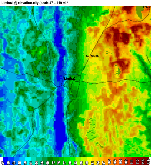
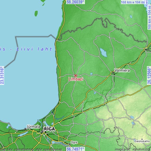
These maps also provides idea of topography and contour of this city, they are displayed at different zoom levels. More info about maps, scale and edge coordinates you can find below images.
| \ | Map #1 | Map #2 | Topo.Map |
| Scale [m] | 47..109 m | 47..119 m | × |
| Scale [ft] | 154..358 ft | 154..390 ft | × |
| Average | 75.3 m = 247 ft | 75.4 m = 247 ft | × |
| Width | 5.25 km = 3.3 mi | 10.5 km = 6.5 mi | 168 km = 104.4 mi |
| Height | 5.25 km = 3.3 mi | 10.5 km = 6.5 mi | 168 km = 104.4 mi |
| ↑Max Latitude | 57.536466° | 57.560046° | 58.26039° |
| Latitude at center | 57.51287° | 57.51287° | 57.51287° |
| ↓Min Latitude | 57.489259° | 57.465633° | 56.74971° |
| ← Min Longitude | 24.675465° | 24.631519° | 23.31316° |
| Longitude center | 24.71941° | 24.71941° | 24.71941° |
| →Max Longitude | 24.763355° | 24.807301° | 26.12566° |
Nearby cities:
Cities around Limbaži sort by population:
• Cēsis elevation 102 m
40.1 km,  123°
123°
• Sigulda 101 m
40.8 km,  168°
168°
• Salacgrīva 7 m
34.3 km,  321°
321°
• Saulkrasti 13 m
33.3 km,  213°
213°
• Aloja 85 m
29.8 km,  18°
18°
• Līgatne 56 m
36.5 km,  148°
148°
• Staicele 51 m
35.9 km,  2°
2°
• Loja 48 m
40.2 km,  186°
186°
• Kocēni 62 m
37 km,  88°
88°
• Ragana 48 m
36.9 km,  181°
181°
• Matīši 69 m
33.4 km,  51°
51°
• Stalbe 66 m
24.5 km,  130°
130°
Multilingual:
 En español:
Limbaži elevación 78 m.
 En France:
Limbaži élévation 78 m.


Sources and notes:
- [note 1] Map square and city borders are not equal. Map elevation data is calculated only from area inside that square.
- [src 1] Elevation data from geonames database provided with same terms of usage.
- [src 2] The elevation map of Limbaži is generated using elevation data from NASA's 3 arcsec (90m) resolution SRTM data.
- [src 3] Base (background) map © OpenStreetMap contributors tiles are generated by Geofabrik and OpenTopoMap.
Copyright & License:
This Limbaži Elevation Map is licensed under CC BY-SA. You may reuse any part from this page, if you give a proper credit by linking to this URL:
 More info on terms of use page.