Sigulda elevation
Sigulda, Latvia elevation is 101 meters and Sigulda elevation in feet is 331 ft above sea level [src 1]. Sigulda is a seat of a first-order administrative division (feature code) with elevation that is 35 meters (115 ft) bigger than average city elevation in Latvia.
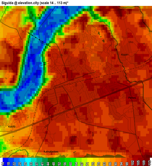
Below is the Elevation map of Sigulda, which displays elevation range with different colors. Scale of the first map is from 14 to 113 m (46 to 371 ft) with average elevation of 86 meters (=282 ft) [note 1]
These maps also provides idea of topography and contour of this city, they are displayed at different zoom levels. More info about maps, scale and edge coordinates you can find below images.
| \ | Map #1 | Map #2 | Topo.Map |
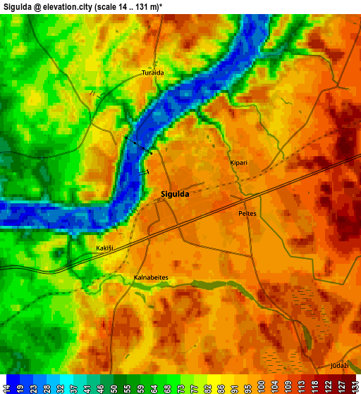
| Scale [m] | 14..113 m | 14..131 m | × |
| Scale [ft] | 46..371 ft | 46..430 ft | × |
| Average | 86 m = 282 ft | 85.2 m = 280 ft | × |
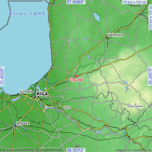
| Width | 5.3 km = 3.3 mi | 10.6 km = 6.6 mi | 169.6 km = 105.4 mi |
| Height | 5.3 km = 3.3 mi | 10.6 km = 6.6 mi | 169.6 km = 105.4 mi |
| ↑Max Latitude | 57.177578° | 57.20139° | 57.90865° |
| Latitude at center | 57.15375° | 57.15375° | 57.15375° |
| ↓Min Latitude | 57.129907° | 57.106049° | 56.38312° |
| ← Min Longitude | 24.815585° | 24.771639° | 23.45328° |
| Longitude center | 24.85953° | 24.85953° | 24.85953° |
| →Max Longitude | 24.903475° | 24.947421° | 26.26578° |
Nearby cities:
Cities around Sigulda sort by population:
• Cēsis elevation 102 m
30.5 km,  54°
54°
• Vangaži 16 m
20.1 km,  250°
250°
• Saulkrasti 13 m
29.4 km,  294°
294°
• Inčukalns 55 m
12.1 km,  239°
239°
• Līgatne 56 m
14.1 km, 50°
• Garkalne 12 m
29.2 km, 245°
• Drabeši 147 m
27.1 km,  68°
68°
• Stalbe 66 m
26.2 km,  23°
23°
• Ropaži 43 m
24.2 km,  214°
214°
• Mālpils 93 m
17 km,  159°
159°
• Loja 48 m
13 km,  269°
269°
• Ragana 48 m
9.7 km, 288°
Multilingual:
 En español:
Sigulda elevación 101 m.
 En France:
Sigulda élévation 101 m.


Sources and notes:
- [note 1] Map square and city borders are not equal. Map elevation data is calculated only from area inside that square.
- [src 1] Elevation data from geonames database provided with same terms of usage.
- [src 2] The elevation map of Sigulda is generated using elevation data from NASA's 3 arcsec (90m) resolution SRTM data.
- [src 3] Base (background) map © OpenStreetMap contributors tiles are generated by Geofabrik and OpenTopoMap.
Copyright & License:
This Sigulda Elevation Map is licensed under CC BY-SA. You may reuse any part from this page, if you give a proper credit by linking to this URL:
 More info on terms of use page.