Cēsis elevation
Cēsis (Cēsu Rajons), Latvia elevation is 102 meters and Cēsis elevation in feet is 335 ft above sea level [src 1]. Cēsis is a seat of a first-order administrative division (feature code) with elevation that is 36 meters (118 ft) bigger than average city elevation in Latvia.
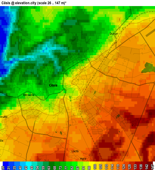
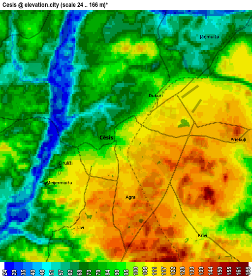
Below is the Elevation map of Cēsis, which displays elevation range with different colors. Scale of the first map is from 26 to 147 m (85 to 482 ft) with average elevation of 98 meters (=322 ft) [note 1]
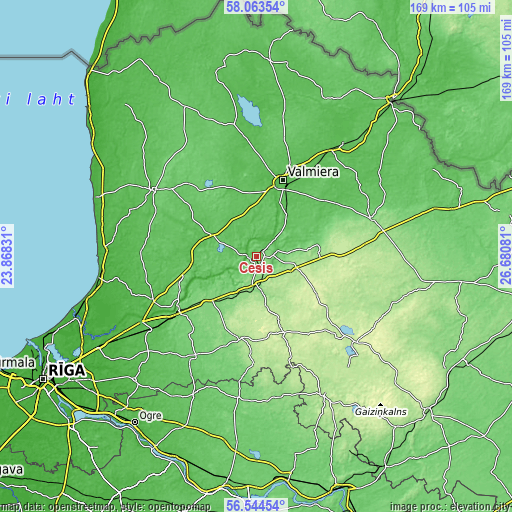
These maps also provides idea of topography and contour of this city, they are displayed at different zoom levels. More info about maps, scale and edge coordinates you can find below images.
| \ | Map #1 | Map #2 | Topo.Map |
| Scale [m] | 26..147 m | 24..166 m | × |
| Scale [ft] | 85..482 ft | 79..545 ft | × |
| Average | 98 m = 322 ft | 91.3 m = 300 ft | × |
| Width | 5.28 km = 3.3 mi | 10.56 km = 6.6 mi | 168.9 km = 104.9 mi |
| Height | 5.28 km = 3.3 mi | 10.56 km = 6.6 mi | 168.9 km = 104.9 mi |
| ↑Max Latitude | 57.335606° | 57.359316° | 58.06354° |
| Latitude at center | 57.31188° | 57.31188° | 57.31188° |
| ↓Min Latitude | 57.288139° | 57.264383° | 56.54454° |
| ← Min Longitude | 25.230615° | 25.186669° | 23.86831° |
| Longitude center | 25.27456° | 25.27456° | 25.27456° |
| →Max Longitude | 25.318505° | 25.362451° | 26.68081° |
Nearby cities:
Cities around Cēsis sort by population:
• Valmiera elevation 43 m
27.1 km,  19°
19°
• Sigulda 101 m
30.5 km,  234°
234°
• Smiltene 98 m
39.6 km,  71°
71°
• Priekuļi 116 m
5.2 km,  86°
86°
• Līgatne 56 m
16.5 km,  238°
238°
• Mālpils 93 m
38.6 km,  209°
209°
• Ragana 48 m
37.1 km,  246°
246°
• Kocēni 62 m
23.5 km,  9°
9°
• Mūrmuiža 57 m
22.2 km,  35°
35°
• Rauna 114 m
20.2 km,  83°
83°
• Stalbe 66 m
16 km,  294°
294°
• Drabeši 147 m
7.6 km,  178°
178°
Multilingual:
 En español:
Cēsis elevación 102 m.
 En France:
Cēsis élévation 102 m.
 Auf Deutsch:
Wenden, Cēsis höhe über dem Meeresspiegel ist 102 m.

Sources and notes:
- [note 1] Map square and city borders are not equal. Map elevation data is calculated only from area inside that square.
- [src 1] Elevation data from geonames database provided with same terms of usage.
- [src 2] The elevation map of Cēsis is generated using elevation data from NASA's 3 arcsec (90m) resolution SRTM data.
- [src 3] Base (background) map © OpenStreetMap contributors tiles are generated by Geofabrik and OpenTopoMap.
Copyright & License:
This Cēsis Elevation Map is licensed under CC BY-SA. You may reuse any part from this page, if you give a proper credit by linking to this URL:
 More info on terms of use page.