Viļāni elevation
Viļāni (Vilanu), Latvia elevation is 116 meters and Viļāni elevation in feet is 381 ft above sea level [src 1]. Viļāni is a seat of a first-order administrative division (feature code) with elevation that is 50 meters (164 ft) bigger than average city elevation in Latvia.
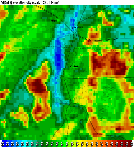
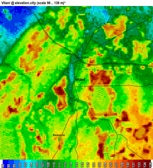
Below is the Elevation map of Viļāni, which displays elevation range with different colors. Scale of the first map is from 103 to 134 m (338 to 440 ft) with average elevation of 117.1 meters (=384 ft) [note 1]
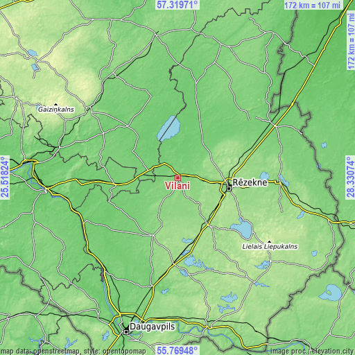
These maps also provides idea of topography and contour of this city, they are displayed at different zoom levels. More info about maps, scale and edge coordinates you can find below images.
| \ | Map #1 | Map #2 | Topo.Map |
| Scale [m] | 103..134 m | 96..136 m | × |
| Scale [ft] | 338..440 ft | 315..446 ft | × |
| Average | 117.1 m = 384 ft | 115.9 m = 380 ft | × |
| Width | 5.39 km = 3.3 mi | 10.77 km = 6.7 mi | 172.4 km = 107.1 mi |
| Height | 5.39 km = 3.3 mi | 10.77 km = 6.7 mi | 172.4 km = 107.1 mi |
| ↑Max Latitude | 56.576744° | 56.600942° | 57.31971° |
| Latitude at center | 56.55253° | 56.55253° | 56.55253° |
| ↓Min Latitude | 56.528301° | 56.504056° | 55.76948° |
| ← Min Longitude | 26.880545° | 26.836599° | 25.51824° |
| Longitude center | 26.92449° | 26.92449° | 26.92449° |
| →Max Longitude | 26.968435° | 27.012381° | 28.33074° |
Nearby cities:
Cities around Viļāni sort by population:
• Rēzekne elevation 156 m
25.9 km,  100°
100°
• Ludza 147 m
48.7 km,  91°
91°
• Līvāni 92 m
51 km,  244°
244°
• Preiļi 127 m
31.2 km,  203°
203°
• Kārsava 101 m
53.3 km,  61°
61°
• Varakļāni 100 m
12.2 km,  300°
300°
• Lubāna 95 m
41.1 km,  341°
341°
• Jaunaglona 146 m
43.9 km,  173°
173°
• Rugāji 102 m
51.7 km,  14°
14°
• Vecvārkava 98 m
47 km,  213°
213°
• Aglona 150 m
47 km, 173°
• Riebiņi 139 m
24.5 km, 198°
Multilingual:
 En español:
Viļāni elevación 116 m.
 En France:
Viļāni élévation 116 m.


Sources and notes:
- [note 1] Map square and city borders are not equal. Map elevation data is calculated only from area inside that square.
- [src 1] Elevation data from geonames database provided with same terms of usage.
- [src 2] The elevation map of Viļāni is generated using elevation data from NASA's 3 arcsec (90m) resolution SRTM data.
- [src 3] Base (background) map © OpenStreetMap contributors tiles are generated by Geofabrik and OpenTopoMap.
Copyright & License:
This Viļāni Elevation Map is licensed under CC BY-SA. You may reuse any part from this page, if you give a proper credit by linking to this URL:
 More info on terms of use page.