Rēzekne elevation
Rēzekne, Latvia elevation is 156 meters and Rēzekne elevation in feet is 512 ft above sea level [src 1]. Rēzekne is a seat of a first-order administrative division (feature code) with elevation that is 90 meters (295 ft) bigger than average city elevation in Latvia.
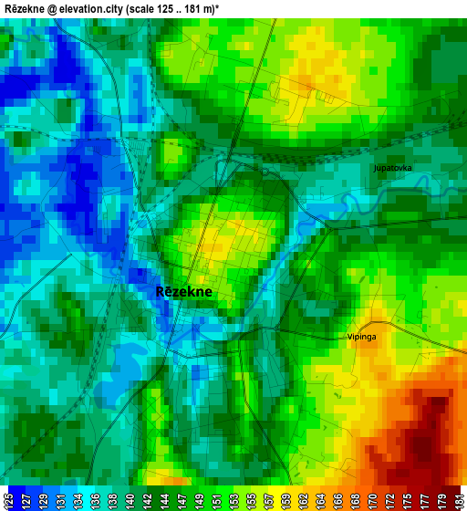
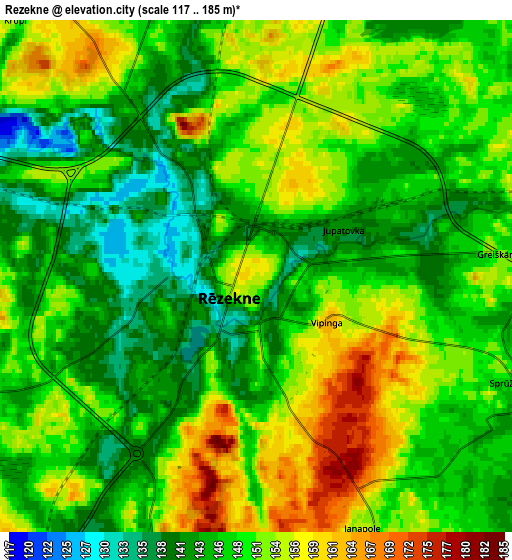
Below is the Elevation map of Rēzekne, which displays elevation range with different colors. Scale of the first map is from 125 to 181 m (410 to 594 ft) with average elevation of 145 meters (=476 ft) [note 1]
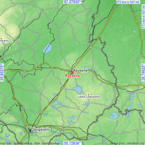
These maps also provides idea of topography and contour of this city, they are displayed at different zoom levels. More info about maps, scale and edge coordinates you can find below images.
| \ | Map #1 | Map #2 | Topo.Map |
| Scale [m] | 125..181 m | 117..185 m | × |
| Scale [ft] | 410..594 ft | 384..607 ft | × |
| Average | 145 m = 476 ft | 148.7 m = 488 ft | × |
| Width | 5.39 km = 3.3 mi | 10.78 km = 6.7 mi | 172.6 km = 107.2 mi |
| Height | 5.39 km = 3.3 mi | 10.78 km = 6.7 mi | 172.5 km = 107.2 mi |
| ↑Max Latitude | 56.534521° | 56.558746° | 57.27832° |
| Latitude at center | 56.51028° | 56.51028° | 56.51028° |
| ↓Min Latitude | 56.486024° | 56.461752° | 55.72636° |
| ← Min Longitude | 27.296055° | 27.252109° | 25.93375° |
| Longitude center | 27.34° | 27.34° | 27.34° |
| →Max Longitude | 27.383945° | 27.427891° | 28.74625° |
Nearby cities:
Cities around Rēzekne sort by population:
• Ludza elevation 147 m
23.5 km,  82°
82°
• Preiļi 127 m
44.8 km,  237°
237°
• Viļāni 116 m
25.9 km,  280°
280°
• Dagda 171 m
47.7 km,  165°
165°
• Kārsava 101 m
37.1 km,  34°
34°
• Varakļāni 100 m
37.5 km,  286°
286°
• Zilupe 124 m
50 km,  106°
106°
• Jaunaglona 146 m
44 km,  207°
207°
• Baltinava 98 m
51.7 km,  21°
21°
• Aglona 150 m
46.7 km, 206°
• Riebiņi 139 m
38.1 km, 240°
• Cibla 118 m
33.6 km, 82°
Multilingual:
 En español:
Rēzekne elevación 156 m.
 En France:
Rezekne élévation 156 m.


Sources and notes:
- [note 1] Map square and city borders are not equal. Map elevation data is calculated only from area inside that square.
- [src 1] Elevation data from geonames database provided with same terms of usage.
- [src 2] The elevation map of Rēzekne is generated using elevation data from NASA's 3 arcsec (90m) resolution SRTM data.
- [src 3] Base (background) map © OpenStreetMap contributors tiles are generated by Geofabrik and OpenTopoMap.
Copyright & License:
This Rēzekne Elevation Map is licensed under CC BY-SA. You may reuse any part from this page, if you give a proper credit by linking to this URL:
 More info on terms of use page.