Colmar elevation
Colmar (Mersch, Berg), Luxembourg elevation is 237 meters and Colmar elevation in feet is 778 ft above sea level [src 1]. Colmar is a section of populated place (feature code) with elevation that is 51 meters (167 ft) smaller than average city elevation in Luxembourg.
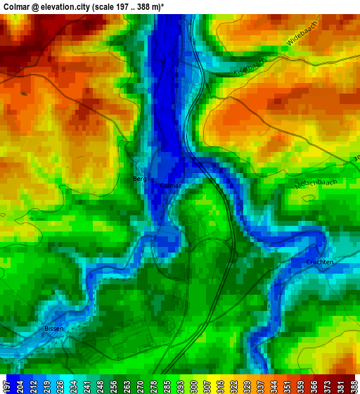
Below is the Elevation map of Colmar, which displays elevation range with different colors. Scale of the first map is from 197 to 388 m (646 to 1273 ft) with average elevation of 282.2 meters (=926 ft) [note 1]
These maps also provides idea of topography and contour of this city, they are displayed at different zoom levels. More info about maps, scale and edge coordinates you can find below images.
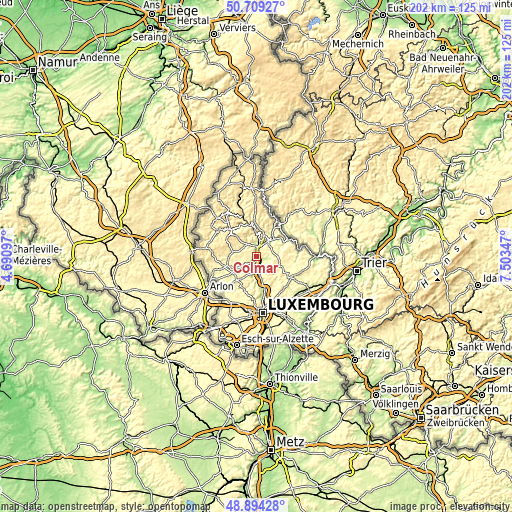
| \ | Map #1 | Topo.Map |
| Scale [m] | 197..388 m | × |
| Scale [ft] | 646..1273 ft | × |
| Average | 282.2 m = 926 ft | × |
| Width | 6.31 km = 3.9 mi | 201.8 km = 125.4 mi |
| Height | 6.31 km = 3.9 mi | 201.8 km = 125.4 mi |
| ↑Max Latitude | 49.838631° | 50.70927° |
| Latitude at center | 49.81028° | 49.81028° |
| ↓Min Latitude | 49.781913° | 48.89428° |
| ← Min Longitude | 6.053275° | 4.69097° |
| Longitude center | 6.09722° | 6.09722° |
| →Max Longitude | 6.141165° | 7.50347° |
Nearby cities:
Cities around Colmar sort by population:
• Ettelbruck elevation 199 m
4.2 km,  6°
6°
• Diekirch 195 m
7.7 km,  33°
33°
• Mersch 219 m
6.9 km,  174°
174°
• Bissen 221 m
3.4 km,  221°
221°
• Mertzig 312 m
7 km,  292°
292°
• Schieren 213 m
2.3 km,  2°
2°
• Warken 214 m
5.5 km,  350°
350°
• Niederfeulen 293 m
6.2 km,  324°
324°
• Erpeldange 207 m
6.2 km, 11°
• Vichten 283 m
7 km,  263°
263°
• Boevange-sur-Attert 265 m
7.2 km,  234°
234°
• Nommern 380 m
6.1 km,  115°
115°
Multilingual:
 En español:
Colmar elevación 237 m.
 En France:
Colmar élévation 237 m.


Sources and notes:
- [note 1] Map square and city borders are not equal. Map elevation data is calculated only from area inside that square.
- [src 1] Elevation data from geonames database provided with same terms of usage.
- [src 2] The elevation map of Colmar is generated using elevation data from NASA's 3 arcsec (90m) resolution SRTM data.
- [src 3] Base (background) map © OpenStreetMap contributors tiles are generated by Geofabrik and OpenTopoMap.
Copyright & License:
This Colmar Elevation Map is licensed under CC BY-SA. You may reuse any part from this page, if you give a proper credit by linking to this URL:
 More info on terms of use page.