Ettelbruck elevation
Ettelbruck (Diekirch), Luxembourg elevation is 199 meters and Ettelbruck elevation in feet is 653 ft above sea level [src 1]. Ettelbruck is a seat of a third-order administrative division (feature code) with elevation that is 89 meters (292 ft) smaller than average city elevation in Luxembourg.
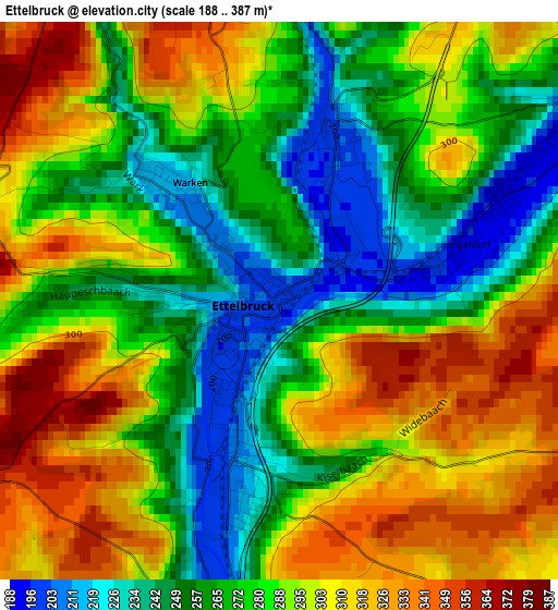
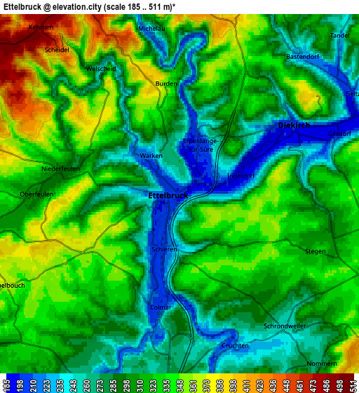
Below is the Elevation map of Ettelbruck, which displays elevation range with different colors. Scale of the first map is from 188 to 387 m (617 to 1270 ft) with average elevation of 284.4 meters (=933 ft) [note 1]
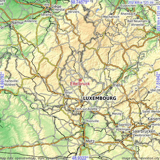
These maps also provides idea of topography and contour of this city, they are displayed at different zoom levels. More info about maps, scale and edge coordinates you can find below images.
| \ | Map #1 | Map #2 | Topo.Map |
| Scale [m] | 188..387 m | 185..511 m | × |
| Scale [ft] | 617..1270 ft | 607..1677 ft | × |
| Average | 284.4 m = 933 ft | 308.7 m = 1013 ft | × |
| Width | 6.3 km = 3.9 mi | 12.6 km = 7.8 mi | 201.7 km = 125.3 mi |
| Height | 6.3 km = 3.9 mi | 12.6 km = 7.8 mi | 201.6 km = 125.3 mi |
| ↑Max Latitude | 49.875829° | 49.904141° | 50.74579° |
| Latitude at center | 49.8475° | 49.8475° | 49.8475° |
| ↓Min Latitude | 49.819155° | 49.790793° | 48.9322° |
| ← Min Longitude | 6.060225° | 6.016279° | 4.69792° |
| Longitude center | 6.10417° | 6.10417° | 6.10417° |
| →Max Longitude | 6.148115° | 6.192061° | 7.51042° |
Nearby cities:
Cities around Ettelbruck sort by population:
• Diekirch elevation 195 m
4.3 km,  58°
58°
• Bissen 221 m
7.2 km,  202°
202°
• Colmar 237 m
4.2 km,  186°
186°
• Mertzig 312 m
7.1 km,  257°
257°
• Schieren 213 m
1.9 km, 191°
• Warken 214 m
1.9 km,  312°
312°
• Niederfeulen 293 m
4.2 km,  282°
282°
• Bettendorf 188 m
8.8 km,  68°
68°
• Erpeldange 207 m
2.1 km,  21°
21°
• Bourscheid 442 m
7.3 km,  338°
338°
• Nommern 380 m
8.4 km,  143°
143°
• Tandel 229 m
7.9 km,  45°
45°
Multilingual:
 En español:
Ettelbruck elevación 199 m.
 En France:
Ettelbruck élévation 199 m.
 Auf Deutsch:
Ettelbrück höhe über dem Meeresspiegel ist 199 m.

Sources and notes:
- [note 1] Map square and city borders are not equal. Map elevation data is calculated only from area inside that square.
- [src 1] Elevation data from geonames database provided with same terms of usage.
- [src 2] The elevation map of Ettelbruck is generated using elevation data from NASA's 3 arcsec (90m) resolution SRTM data.
- [src 3] Base (background) map © OpenStreetMap contributors tiles are generated by Geofabrik and OpenTopoMap.
Copyright & License:
This Ettelbruck Elevation Map is licensed under CC BY-SA. You may reuse any part from this page, if you give a proper credit by linking to this URL:
 More info on terms of use page.