Kazlų Rūda elevation
Kazlų Rūda (Marijampolė County, Kazlų Rūda Municipality), Lithuania elevation is 69 meters and Kazlų Rūda elevation in feet is 226 ft above sea level [src 1]. Kazlų Rūda is a populated place (feature code) with elevation that is 24 meters (79 ft) smaller than average city elevation in Lithuania.
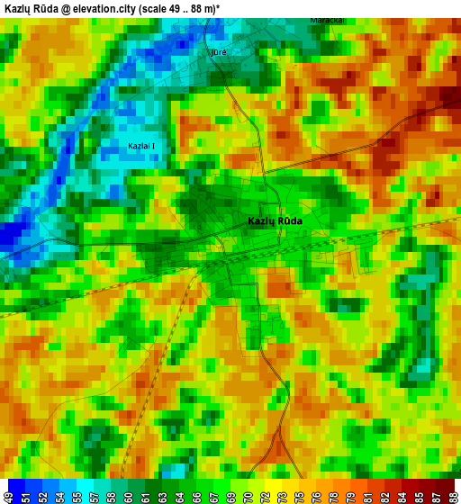
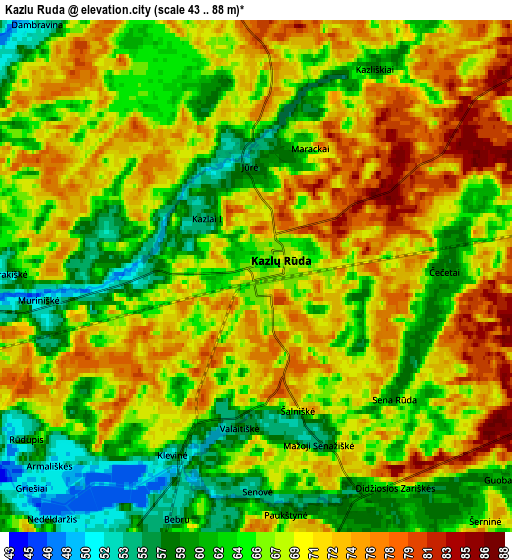
Below is the Elevation map of Kazlų Rūda, which displays elevation range with different colors. Scale of the first map is from 49 to 88 m (161 to 289 ft) with average elevation of 69.1 meters (=227 ft) [note 1]
These maps also provides idea of topography and contour of this city, they are displayed at different zoom levels. More info about maps, scale and edge coordinates you can find below images.
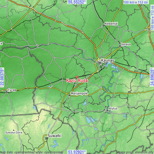
| \ | Map #1 | Map #2 | Topo.Map |
| Scale [m] | 49..88 m | 43..88 m | × |
| Scale [ft] | 161..289 ft | 141..289 ft | × |
| Average | 69.1 m = 227 ft | 67.6 m = 222 ft | × |
| Width | 5.64 km = 3.5 mi | 11.28 km = 7 mi | 180.5 km = 112.2 mi |
| Height | 5.64 km = 3.5 mi | 11.28 km = 7 mi | 180.5 km = 112.2 mi |
| ↑Max Latitude | 54.774356° | 54.799695° | 55.55252° |
| Latitude at center | 54.749° | 54.749° | 54.749° |
| ↓Min Latitude | 54.723629° | 54.698241° | 53.92921° |
| ← Min Longitude | 23.446055° | 23.402109° | 22.08375° |
| Longitude center | 23.49° | 23.49° | 23.49° |
| →Max Longitude | 23.533945° | 23.577891° | 24.89625° |
Nearby cities:
Cities around Kazlų Rūda sort by population:
• Kaunas elevation 74 m
31.9 km,  57°
57°
• Marijampolė 69 m
22.8 km,  202°
202°
• Šilainiai 68 m
32.3 km,  51°
51°
• Aleksotas 73 m
30.5 km, 61°
• Garliava 72 m
25.7 km,  71°
71°
• Vilkaviskis 55 m
31.3 km,  249°
249°
• Prienai 59 m
31.9 km,  113°
113°
• Akademija (Kaunas) 75 m
27 km, 52°
• Vilkija 81 m
33.6 km,  10°
10°
• Ežerėlis 72 m
16.6 km,  26°
26°
• Kulautuva 34 m
23.6 km,  24°
24°
• Mastaiciai 77 m
24.1 km, 70°
Multilingual:
 En español:
Kazlų Rūda elevación 69 m.
 En France:
Kazlų Rūda élévation 69 m.
 Auf Deutsch:
Kazlų Rūda höhe über dem Meeresspiegel ist 69 m.

Sources and notes:
- [note 1] Map square and city borders are not equal. Map elevation data is calculated only from area inside that square.
- [src 1] Elevation data from geonames database provided with same terms of usage.
- [src 2] The elevation map of Kazlų Rūda is generated using elevation data from NASA's 3 arcsec (90m) resolution SRTM data.
- [src 3] Base (background) map © OpenStreetMap contributors tiles are generated by Geofabrik and OpenTopoMap.
Copyright & License:
This Kazlų Rūda Elevation Map is licensed under CC BY-SA. You may reuse any part from this page, if you give a proper credit by linking to this URL:
 More info on terms of use page.