Prienai elevation
Prienai (Kaunas), Lithuania elevation is 59 meters and Prienai elevation in feet is 194 ft above sea level [src 1]. Prienai is a seat of a second-order administrative division (feature code) with elevation that is 34 meters (112 ft) smaller than average city elevation in Lithuania.
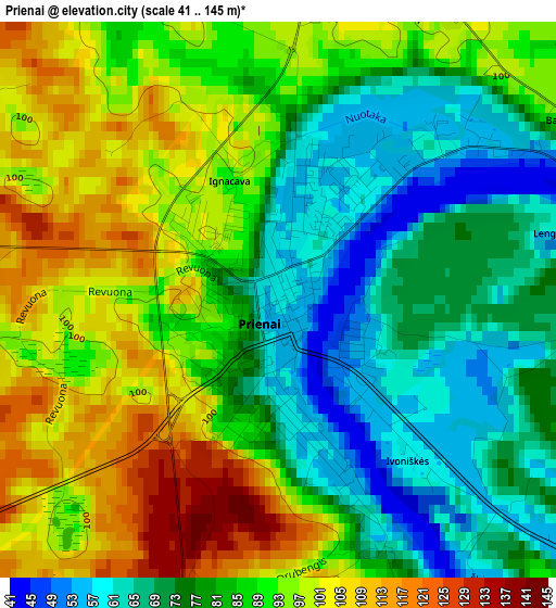
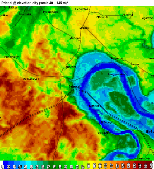
Below is the Elevation map of Prienai, which displays elevation range with different colors. Scale of the first map is from 41 to 145 m (135 to 476 ft) with average elevation of 84.8 meters (=278 ft) [note 1]
These maps also provides idea of topography and contour of this city, they are displayed at different zoom levels. More info about maps, scale and edge coordinates you can find below images.
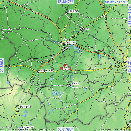
| \ | Map #1 | Map #2 | Topo.Map |
| Scale [m] | 41..145 m | 40..145 m | × |
| Scale [ft] | 135..476 ft | 131..476 ft | × |
| Average | 84.8 m = 278 ft | 93.1 m = 305 ft | × |
| Width | 5.66 km = 3.5 mi | 11.31 km = 7 mi | 181 km = 112.5 mi |
| Height | 5.66 km = 3.5 mi | 11.31 km = 7 mi | 181 km = 112.5 mi |
| ↑Max Latitude | 54.661426° | 54.686837° | 55.44178° |
| Latitude at center | 54.636° | 54.636° | 54.636° |
| ↓Min Latitude | 54.610558° | 54.5851° | 53.81393° |
| ← Min Longitude | 23.901905° | 23.857959° | 22.5396° |
| Longitude center | 23.94585° | 23.94585° | 23.94585° |
| →Max Longitude | 23.989795° | 24.033741° | 25.3521° |
Nearby cities:
Cities around Prienai sort by population:
• Kaunas elevation 74 m
29.7 km,  355°
355°
• Alytus 89 m
27.4 km,  166°
166°
• Dainava (Kaunas) 70 m
31.1 km,  2°
2°
• Eiguliai 69 m
32.8 km, 358°
• Šilainiai 68 m
32.8 km,  353°
353°
• Aleksotas 73 m
27.3 km, 354°
• Garliava 72 m
21.2 km, 346°
• Kazlų Rūda 69 m
31.9 km,  293°
293°
• Birštonas 56 m
6.5 km,  118°
118°
• Akademija (Kaunas) 75 m
30 km,  344°
344°
• Jieznas 110 m
15.4 km,  105°
105°
• Mastaiciai 77 m
21.5 km, 342°
Multilingual:
 En español:
Prienai elevación 59 m.
 En France:
Prienai élévation 59 m.


Sources and notes:
- [note 1] Map square and city borders are not equal. Map elevation data is calculated only from area inside that square.
- [src 1] Elevation data from geonames database provided with same terms of usage.
- [src 2] The elevation map of Prienai is generated using elevation data from NASA's 3 arcsec (90m) resolution SRTM data.
- [src 3] Base (background) map © OpenStreetMap contributors tiles are generated by Geofabrik and OpenTopoMap.
Copyright & License:
This Prienai Elevation Map is licensed under CC BY-SA. You may reuse any part from this page, if you give a proper credit by linking to this URL:
 More info on terms of use page.