Trincomalee elevation
Trincomalee (Eastern Province), Sri Lanka elevation is 4 meters and Trincomalee elevation in feet is 13 ft above sea level [src 1]. Trincomalee is a seat of a first-order administrative division (feature code) with elevation that is 153 meters (502 ft) smaller than average city elevation in Sri Lanka.
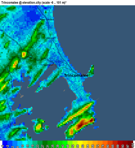
Below is the Elevation map of Trincomalee, which displays elevation range with different colors. Scale of the first map is from -6 to 101 m (-20 to 331 ft) with average elevation of 18.4 meters (=60 ft) [note 1]
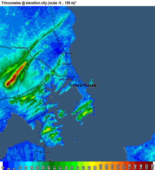
These maps also provides idea of topography and contour of this city, they are displayed at different zoom levels. More info about maps, scale and edge coordinates you can find below images.
| \ | Map #1 | Map #2 | Topo.Map |
| Scale [m] | -6..101 m | -6..159 m | × |
| Scale [ft] | -20..331 ft | -20..522 ft | × |
| Average | 18.4 m = 60 ft | 20.1 m = 66 ft | × |
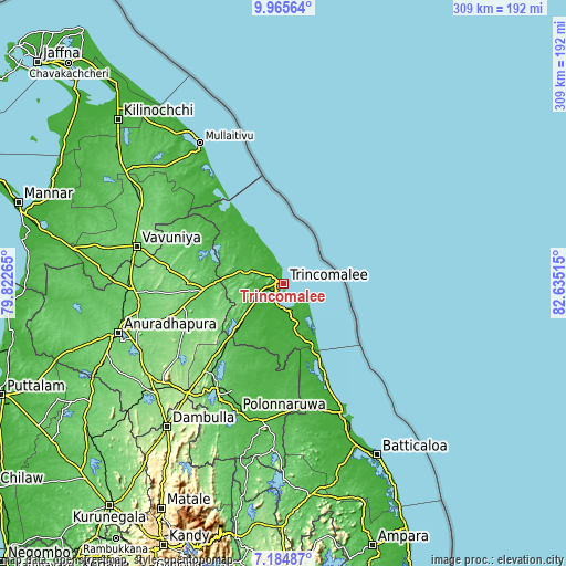
| Width | 9.66 km = 6 mi | 19.33 km = 12 mi | 309.2 km = 192.1 mi |
| Height | 9.66 km = 6 mi | 19.33 km = 12 mi | 309.2 km = 192.1 mi |
| ↑Max Latitude | 8.621251° | 8.664698° | 9.96564° |
| Latitude at center | 8.5778° | 8.5778° | 8.5778° |
| ↓Min Latitude | 8.534344° | 8.490883° | 7.18487° |
| ← Min Longitude | 81.184955° | 81.141009° | 79.82265° |
| Longitude center | 81.2289° | 81.2289° | 81.2289° |
| →Max Longitude | 81.272845° | 81.316791° | 82.63515° |
Nearby cities:
Cities around Trincomalee sort by population:
• Batticaloa elevation 17 m
109.1 km,  152°
152°
• Dambulla 168 m
102 km,  218°
218°
• Anuradhapura 100 m
94.5 km,  251°
251°
• Vavuniya 104 m
82.7 km,  283°
283°
• Matale 366 m
140.2 km,  208°
208°
• Eravur Town 10 m
98 km,  155°
155°
• Vakarai 9 m
54.3 km, 155°
• Polonnaruwa 60 m
75.2 km,  199°
199°
• Kilinochchi 24 m
128.8 km,  314°
314°
• Mihintale 113 m
82.7 km, 252°
• Sigiriya 207 m
87.5 km, 217°
• Padaviya Divisional Secretariat 48 m
59.2 km,  300°
300°
Multilingual:
 En español:
Trincomalee elevación 4 m.
 En France:
Trinquemalay élévation 4 m.
 Auf Deutsch:
Trincomalee höhe über dem Meeresspiegel ist 4 m.
 На русском:
Тринкомали, Трикомали высота над уровнем моря 4 м
Sources and notes:
- [note 1] Map square and city borders are not equal. Map elevation data is calculated only from area inside that square.
- [src 1] Elevation data from geonames database provided with same terms of usage.
- [src 2] The elevation map of Trincomalee is generated using elevation data from NASA's 3 arcsec (90m) resolution SRTM data.
- [src 3] Base (background) map © OpenStreetMap contributors tiles are generated by Geofabrik and OpenTopoMap.
Copyright & License:
This Trincomalee Elevation Map is licensed under CC BY-SA. You may reuse any part from this page, if you give a proper credit by linking to this URL:
 More info on terms of use page.