Dambulla elevation
Dambulla (Central, Matale District), Sri Lanka elevation is 168 meters and Dambulla elevation in feet is 551 ft above sea level [src 1]. Dambulla is a populated place (feature code) with elevation that is 11 meters (36 ft) bigger than average city elevation in Sri Lanka.
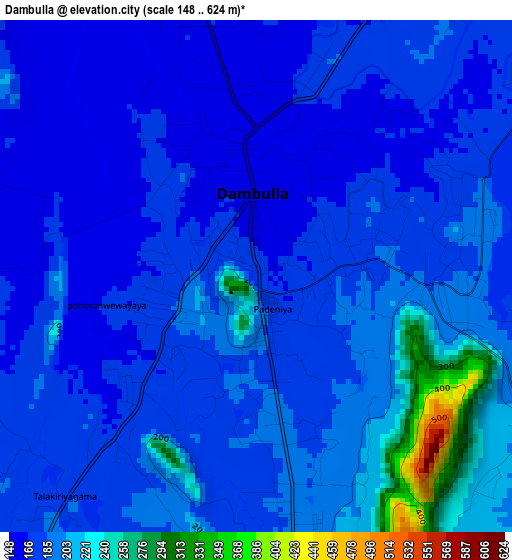
Below is the Elevation map of Dambulla, which displays elevation range with different colors. Scale of the first map is from 148 to 624 m (486 to 2047 ft) with average elevation of 185.9 meters (=610 ft) [note 1]
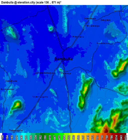
These maps also provides idea of topography and contour of this city, they are displayed at different zoom levels. More info about maps, scale and edge coordinates you can find below images.
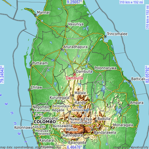
| \ | Map #1 | Map #2 | Topo.Map |
| Scale [m] | 148..624 m | 136..871 m | × |
| Scale [ft] | 486..2047 ft | 446..2858 ft | × |
| Average | 185.9 m = 610 ft | 205.4 m = 674 ft | × |
| Width | 9.68 km = 6 mi | 19.36 km = 12 mi | 309.8 km = 192.5 mi |
| Height | 9.68 km = 6 mi | 19.36 km = 12 mi | 309.8 km = 192.5 mi |
| ↑Max Latitude | 7.90353° | 7.947056° | 9.25057° |
| Latitude at center | 7.86° | 7.86° | 7.86° |
| ↓Min Latitude | 7.816465° | 7.772926° | 6.46476° |
| ← Min Longitude | 80.607725° | 80.563779° | 79.24542° |
| Longitude center | 80.65167° | 80.65167° | 80.65167° |
| →Max Longitude | 80.695615° | 80.739561° | 82.05792° |
Nearby cities:
Cities around Dambulla sort by population:
• Kandy elevation 514 m
63.3 km,  181°
181°
• Anuradhapura 100 m
56.7 km,  332°
332°
• Matale 366 m
43.5 km, 184°
• Kurunegala 186 m
52.2 km,  216°
216°
• Gampola 492 m
77.9 km,  186°
186°
• Vakarai 9 m
91.3 km,  70°
70°
• Kegalle 176 m
75.6 km,  206°
206°
• Polonnaruwa 60 m
39.7 km,  77°
77°
• Kuliyapitiya 33 m
80.2 km,  237°
237°
• Mihintale 113 m
57.7 km,  344°
344°
• Kadugannawa 580 m
68.8 km, 191°
• Sigiriya 207 m
14.7 km,  47°
47°
Multilingual:
 En español:
Dambulla elevación 168 m.
 En France:
Dambulla élévation 168 m.
 Auf Deutsch:
Dambulla höhe über dem Meeresspiegel ist 168 m.

Sources and notes:
- [note 1] Map square and city borders are not equal. Map elevation data is calculated only from area inside that square.
- [src 1] Elevation data from geonames database provided with same terms of usage.
- [src 2] The elevation map of Dambulla is generated using elevation data from NASA's 3 arcsec (90m) resolution SRTM data.
- [src 3] Base (background) map © OpenStreetMap contributors tiles are generated by Geofabrik and OpenTopoMap.
Copyright & License:
This Dambulla Elevation Map is licensed under CC BY-SA. You may reuse any part from this page, if you give a proper credit by linking to this URL:
 More info on terms of use page.