Kegalle elevation
Kegalle (Sabaragamuwa, Kegalle District), Sri Lanka elevation is 176 meters and Kegalle elevation in feet is 577 ft above sea level [src 1]. Kegalle is a populated place (feature code) with elevation that is 19 meters (62 ft) bigger than average city elevation in Sri Lanka.
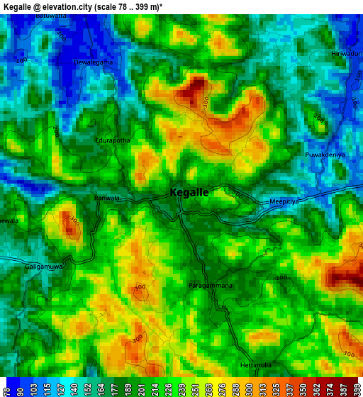
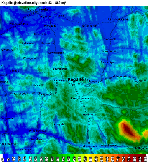
Below is the Elevation map of Kegalle, which displays elevation range with different colors. Scale of the first map is from 78 to 399 m (256 to 1309 ft) with average elevation of 202.8 meters (=665 ft) [note 1]
These maps also provides idea of topography and contour of this city, they are displayed at different zoom levels. More info about maps, scale and edge coordinates you can find below images.
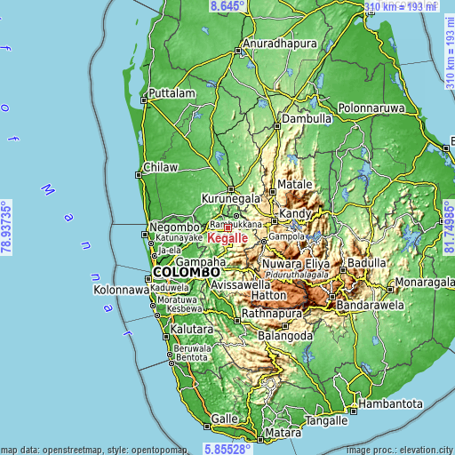
| \ | Map #1 | Map #2 | Topo.Map |
| Scale [m] | 78..399 m | 43..869 m | × |
| Scale [ft] | 256..1309 ft | 141..2851 ft | × |
| Average | 202.8 m = 665 ft | 183.9 m = 603 ft | × |
| Width | 9.69 km = 6 mi | 19.39 km = 12 mi | 310.2 km = 192.7 mi |
| Height | 9.69 km = 6 mi | 19.39 km = 12 mi | 310.2 km = 192.7 mi |
| ↑Max Latitude | 7.295892° | 7.339479° | 8.645° |
| Latitude at center | 7.2523° | 7.2523° | 7.2523° |
| ↓Min Latitude | 7.208704° | 7.165104° | 5.85528° |
| ← Min Longitude | 80.299655° | 80.255709° | 78.93735° |
| Longitude center | 80.3436° | 80.3436° | 80.3436° |
| →Max Longitude | 80.387545° | 80.431491° | 81.74985° |
Nearby cities:
Cities around Kegalle sort by population:
• Kandy elevation 514 m
32.3 km,  82°
82°
• Katunayaka 13 m
51 km,  259°
259°
• Matale 366 m
39.1 km,  51°
51°
• Kurunegala 186 m
25.9 km,  6°
6°
• Gampola 492 m
26.8 km,  111°
111°
• Hanwella Ihala 14 m
48.3 km,  216°
216°
• Hatton 1309 m
48.8 km,  145°
145°
• Gampaha 21 m
42.7 km,  244°
244°
• Minuwangoda 18 m
44.1 km, 257°
• Kuliyapitiya 33 m
41.2 km,  305°
305°
• Talawakele 1217 m
49.3 km,  135°
135°
• Kadugannawa 580 m
19.9 km,  89°
89°
Multilingual:
 En español:
Kegalle elevación 176 m.
 En France:
Kegalle élévation 176 m.


Sources and notes:
- [note 1] Map square and city borders are not equal. Map elevation data is calculated only from area inside that square.
- [src 1] Elevation data from geonames database provided with same terms of usage.
- [src 2] The elevation map of Kegalle is generated using elevation data from NASA's 3 arcsec (90m) resolution SRTM data.
- [src 3] Base (background) map © OpenStreetMap contributors tiles are generated by Geofabrik and OpenTopoMap.
Copyright & License:
This Kegalle Elevation Map is licensed under CC BY-SA. You may reuse any part from this page, if you give a proper credit by linking to this URL:
 More info on terms of use page.