Hanwella Ihala elevation
Hanwella Ihala (Western, Colombo District), Sri Lanka elevation is 14 meters and Hanwella Ihala elevation in feet is 46 ft above sea level [src 1]. Hanwella Ihala is a populated place (feature code) with elevation that is 143 meters (469 ft) smaller than average city elevation in Sri Lanka.
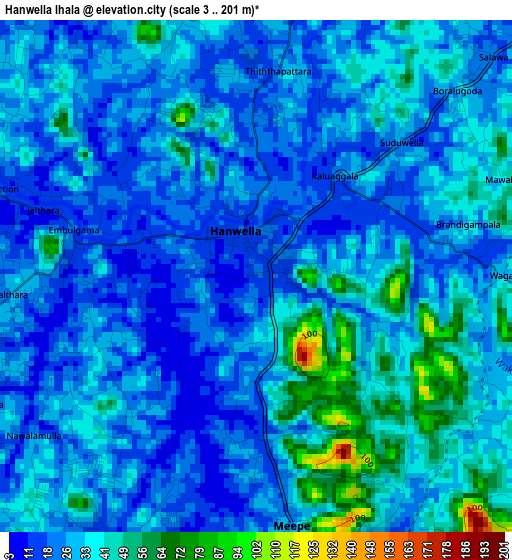
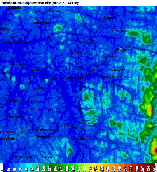
Below is the Elevation map of Hanwella Ihala, which displays elevation range with different colors. Scale of the first map is from 3 to 201 m (10 to 659 ft) with average elevation of 30.7 meters (=101 ft) [note 1]
These maps also provides idea of topography and contour of this city, they are displayed at different zoom levels. More info about maps, scale and edge coordinates you can find below images.
| \ | Map #1 | Map #2 | Topo.Map |
| Scale [m] | 3..201 m | 2..441 m | × |
| Scale [ft] | 10..659 ft | 7..1447 ft | × |
| Average | 30.7 m = 101 ft | 40.5 m = 133 ft | × |
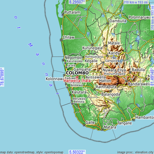
| Width | 9.7 km = 6 mi | 19.4 km = 12.1 mi | 310.4 km = 192.9 mi |
| Height | 9.7 km = 6 mi | 19.4 km = 12.1 mi | 310.5 km = 192.9 mi |
| ↑Max Latitude | 6.944825° | 6.988446° | 8.29507° |
| Latitude at center | 6.9012° | 6.9012° | 6.9012° |
| ↓Min Latitude | 6.857571° | 6.813938° | 5.50322° |
| ← Min Longitude | 80.041255° | 79.997309° | 78.67895° |
| Longitude center | 80.0852° | 80.0852° | 80.0852° |
| →Max Longitude | 80.129145° | 80.173091° | 81.49145° |
Nearby cities:
Cities around Hanwella Ihala sort by population:
• Pita Kotte elevation 20 m
20.3 km,  266°
266°
• Sri Jayewardenepura Kotte 27 m
19.8 km,  264°
264°
• Battaramulla South 11 m
18.5 km, 268°
• Maharagama 26 m
18.5 km,  251°
251°
• Kotikawatta 16 m
19.6 km,  278°
278°
• Kolonnawa 20 m
22.4 km, 279°
• Homagama 37 m
11.1 km,  235°
235°
• Mulleriyawa 8 m
17.5 km, 281°
• Peliyagoda 7 m
23.5 km,  288°
288°
• Kelaniya 10 m
19 km, 288°
• Gampaha 21 m
23.3 km,  333°
333°
• Horana South 23 m
20.8 km,  186°
186°
Multilingual:
 En español:
Hanwella Ihala elevación 14 m.
 En France:
Hanwella Ihala élévation 14 m.
 Auf Deutsch:
Hanwella Ihala höhe über dem Meeresspiegel ist 14 m.

Sources and notes:
- [note 1] Map square and city borders are not equal. Map elevation data is calculated only from area inside that square.
- [src 1] Elevation data from geonames database provided with same terms of usage.
- [src 2] The elevation map of Hanwella Ihala is generated using elevation data from NASA's 3 arcsec (90m) resolution SRTM data.
- [src 3] Base (background) map © OpenStreetMap contributors tiles are generated by Geofabrik and OpenTopoMap.
Copyright & License:
This Hanwella Ihala Elevation Map is licensed under CC BY-SA. You may reuse any part from this page, if you give a proper credit by linking to this URL:
 More info on terms of use page.