Vavuniya elevation
Vavuniya (Northern Province, Vavuniya District), Sri Lanka elevation is 104 meters and Vavuniya elevation in feet is 341 ft above sea level [src 1]. Vavuniya is a populated place (feature code) with elevation that is 53 meters (174 ft) smaller than average city elevation in Sri Lanka.
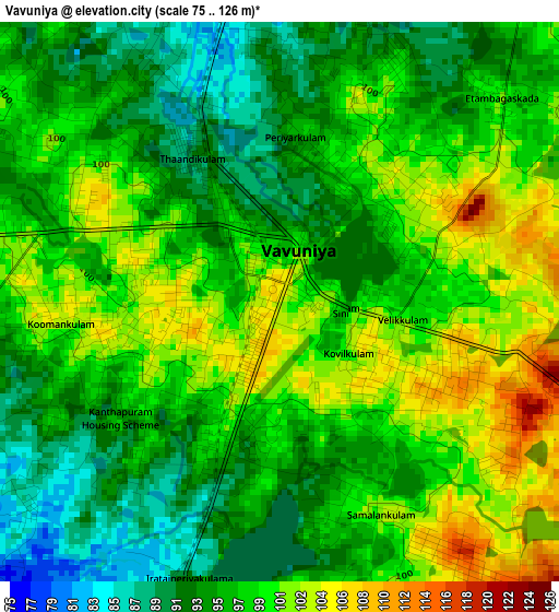
Below is the Elevation map of Vavuniya, which displays elevation range with different colors. Scale of the first map is from 75 to 126 m (246 to 413 ft) with average elevation of 97 meters (=318 ft) [note 1]
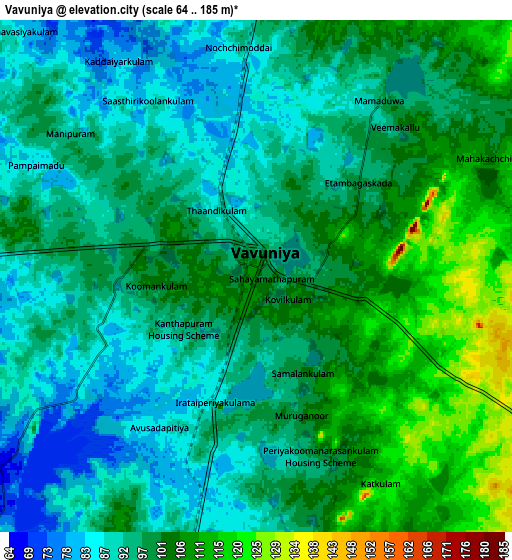
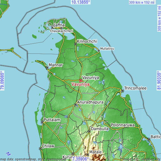
These maps also provides idea of topography and contour of this city, they are displayed at different zoom levels. More info about maps, scale and edge coordinates you can find below images.
| \ | Map #1 | Map #2 | Topo.Map |
| Scale [m] | 75..126 m | 64..185 m | × |
| Scale [ft] | 246..413 ft | 210..607 ft | × |
| Average | 97 m = 318 ft | 97.8 m = 321 ft | × |
| Width | 9.66 km = 6 mi | 19.32 km = 12 mi | 309.1 km = 192.1 mi |
| Height | 9.66 km = 6 mi | 19.32 km = 12 mi | 309.1 km = 192.1 mi |
| ↑Max Latitude | 8.794831° | 8.838257° | 10.13855° |
| Latitude at center | 8.7514° | 8.7514° | 8.7514° |
| ↓Min Latitude | 8.707964° | 8.664523° | 7.35906° |
| ← Min Longitude | 80.453155° | 80.409209° | 79.09085° |
| Longitude center | 80.4971° | 80.4971° | 80.4971° |
| →Max Longitude | 80.541045° | 80.584991° | 81.90335° |
Nearby cities:
Cities around Vavuniya sort by population:
• Jaffna elevation 7 m
115.3 km,  332°
332°
• Trincomalee 4 m
82.7 km,  103°
103°
• Point Pedro 12 m
121.9 km,  346°
346°
• Dambulla 168 m
100.6 km,  170°
170°
• Anuradhapura 100 m
49.7 km,  190°
190°
• Puttalam 8 m
108.3 km,  222°
222°
• Vakarai 9 m
123.8 km,  123°
123°
• Polonnaruwa 60 m
106 km,  148°
148°
• Kilinochchi 24 m
72.5 km, 351°
• Mihintale 113 m
43.6 km,  178°
178°
• Sigiriya 207 m
93.4 km,  162°
162°
• Padaviya Divisional Secretariat 48 m
31 km,  70°
70°
Multilingual:
 En español:
Vavuniya elevación 104 m.
 En France:
Vavuniya élévation 104 m.
 Auf Deutsch:
Vavuniya höhe über dem Meeresspiegel ist 104 m.

Sources and notes:
- [note 1] Map square and city borders are not equal. Map elevation data is calculated only from area inside that square.
- [src 1] Elevation data from geonames database provided with same terms of usage.
- [src 2] The elevation map of Vavuniya is generated using elevation data from NASA's 3 arcsec (90m) resolution SRTM data.
- [src 3] Base (background) map © OpenStreetMap contributors tiles are generated by Geofabrik and OpenTopoMap.
Copyright & License:
This Vavuniya Elevation Map is licensed under CC BY-SA. You may reuse any part from this page, if you give a proper credit by linking to this URL:
 More info on terms of use page.