Shubarköl elevation
Shubarköl (Karaganda), Kazakhstan elevation is 442 meters and Shubarköl elevation in feet is 1450 ft above sea level [src 1]. Shubarköl is a populated place (feature code) with elevation that is 84 meters (276 ft) bigger than average city elevation in Kazakhstan.
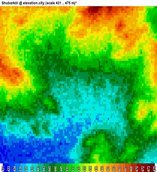
Below is the Elevation map of Shubarköl, which displays elevation range with different colors. Scale of the first map is from 431 to 475 m (1414 to 1558 ft) with average elevation of 448.6 meters (=1472 ft) [note 1]
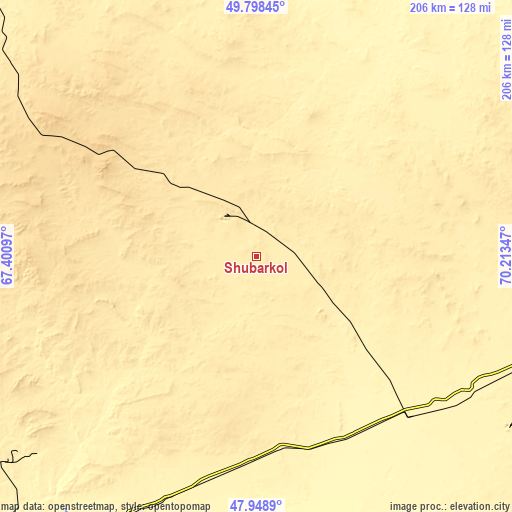
These maps also provides idea of topography and contour of this city, they are displayed at different zoom levels. More info about maps, scale and edge coordinates you can find below images.
| \ | Map #1 | Topo.Map |
| Scale [m] | 431..475 m | × |
| Scale [ft] | 1414..1558 ft | × |
| Average | 448.6 m = 1472 ft | × |
| Width | 6.43 km = 4 mi | 205.7 km = 127.8 mi |
| Height | 6.43 km = 4 mi | 205.6 km = 127.8 mi |
| ↑Max Latitude | 48.91111° | 49.79845° |
| Latitude at center | 48.88222° | 48.88222° |
| ↓Min Latitude | 48.853313° | 47.9489° |
| ← Min Longitude | 68.763275° | 67.40097° |
| Longitude center | 68.80722° | 68.80722° |
| →Max Longitude | 68.851165° | 70.21347° |
Nearby cities:
Cities around Shubarköl sort by population:
• Zhezqazghan elevation 330 m
144.4 km,  212°
212°
• Arkalyk 349 m
204 km,  318°
318°
• Shakhtinsk 488 m
289.4 km,  71°
71°
• Qarazhal 468 m
176.1 km,  123°
123°
• Shakhan 478 m
297.4 km, 69°
• Atasū 487 m
209 km,  95°
95°
• Kīevka 397 m
250.2 km,  52°
52°
• Novodolinskiy 484 m
297.3 km, 72°
• Dolinka 491 m
294.3 km, 72°
• Egindiköl 340 m
246.2 km,  11°
11°
• Kyzylzhar 468 m
300.7 km, 66°
• Zhambyl 611 m
267.8 km,  134°
134°
Multilingual:
 En español:
Shubarköl elevación 442 m.
 En France:
Shubarköl élévation 442 m.
 Auf Deutsch:
Shubarköl höhe über dem Meeresspiegel ist 442 m.

Sources and notes:
- [note 1] Map square and city borders are not equal. Map elevation data is calculated only from area inside that square.
- [src 1] Elevation data from geonames database provided with same terms of usage.
- [src 2] The elevation map of Shubarköl is generated using elevation data from NASA's 3 arcsec (90m) resolution SRTM data.
- [src 3] Base (background) map © OpenStreetMap contributors tiles are generated by Geofabrik and OpenTopoMap.
Copyright & License:
This Shubarköl Elevation Map is licensed under CC BY-SA. You may reuse any part from this page, if you give a proper credit by linking to this URL:
 More info on terms of use page.