Qarqaraly elevation
Qarqaraly (Karaganda), Kazakhstan elevation is 849 meters and Qarqaraly elevation in feet is 2785 ft above sea level [src 1]. Qarqaraly is a populated place (feature code) with elevation that is 491 meters (1611 ft) bigger than average city elevation in Kazakhstan.
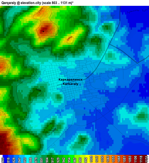
Below is the Elevation map of Qarqaraly, which displays elevation range with different colors. Scale of the first map is from 803 to 1131 m (2635 to 3711 ft) with average elevation of 880.7 meters (=2889 ft) [note 1]
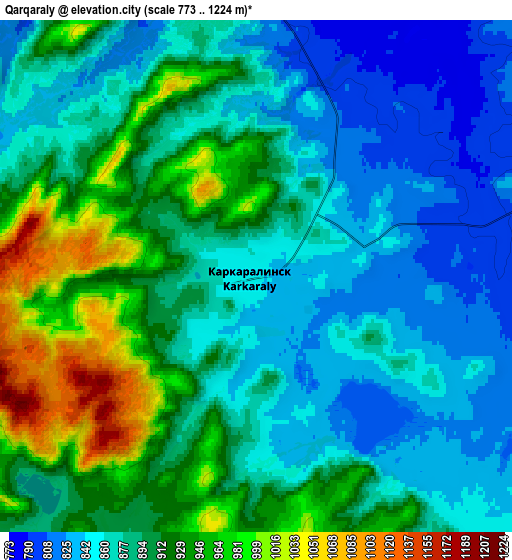
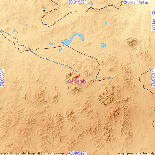
These maps also provides idea of topography and contour of this city, they are displayed at different zoom levels. More info about maps, scale and edge coordinates you can find below images.
| \ | Map #1 | Map #2 | Topo.Map |
| Scale [m] | 803..1131 m | 773..1224 m | × |
| Scale [ft] | 2635..3711 ft | 2536..4016 ft | × |
| Average | 880.7 m = 2889 ft | 891.7 m = 2926 ft | × |
| Width | 6.36 km = 4 mi | 12.72 km = 7.9 mi | 203.5 km = 126.4 mi |
| Height | 6.36 km = 4 mi | 12.72 km = 7.9 mi | 203.4 km = 126.4 mi |
| ↑Max Latitude | 49.441453° | 49.470019° | 50.31927° |
| Latitude at center | 49.41287° | 49.41287° | 49.41287° |
| ↓Min Latitude | 49.384271° | 49.355655° | 48.48942° |
| ← Min Longitude | 75.428915° | 75.384969° | 74.06661° |
| Longitude center | 75.47286° | 75.47286° | 75.47286° |
| →Max Longitude | 75.516805° | 75.560751° | 76.87911° |
Nearby cities:
Cities around Qarqaraly sort by population:
• Karagandy elevation 537 m
176.2 km,  284°
284°
• Abay 503 m
190.1 km, 277°
• Aktas 558 m
185.5 km, 282°
• Bayanaul 474 m
154.3 km,  6°
6°
• Aqshataū 751 m
189.3 km,  213°
213°
• Aksu-Ayuly 729 m
149.4 km,  241°
241°
• Tokarevka 492 m
183.5 km,  295°
295°
• Kushoky 516 m
174.2 km, 301°
• Aktogay 753 m
139.1 km,  185°
185°
• Prigorodnoye 678 m
32.1 km, 14°
• Koktal 552 m
143.6 km, 280°
• Verkhniye Kayrakty 803 m
179 km, 243°
Multilingual:
 En español:
Qarqaraly elevación 849 m.
 En France:
Qarqaraly élévation 849 m.
 Auf Deutsch:
Qarqaraly höhe über dem Meeresspiegel ist 849 m.

Sources and notes:
- [note 1] Map square and city borders are not equal. Map elevation data is calculated only from area inside that square.
- [src 1] Elevation data from geonames database provided with same terms of usage.
- [src 2] The elevation map of Qarqaraly is generated using elevation data from NASA's 3 arcsec (90m) resolution SRTM data.
- [src 3] Base (background) map © OpenStreetMap contributors tiles are generated by Geofabrik and OpenTopoMap.
Copyright & License:
This Qarqaraly Elevation Map is licensed under CC BY-SA. You may reuse any part from this page, if you give a proper credit by linking to this URL:
 More info on terms of use page.