At-Bashi elevation
At-Bashi (Naryn), Kyrgyzstan elevation is 2047 meters and At-Bashi elevation in feet is 6716 ft above sea level [src 1]. At-Bashi is a seat of a second-order administrative division (feature code) with elevation that is 851 meters (2792 ft) bigger than average city elevation in Kyrgyzstan.
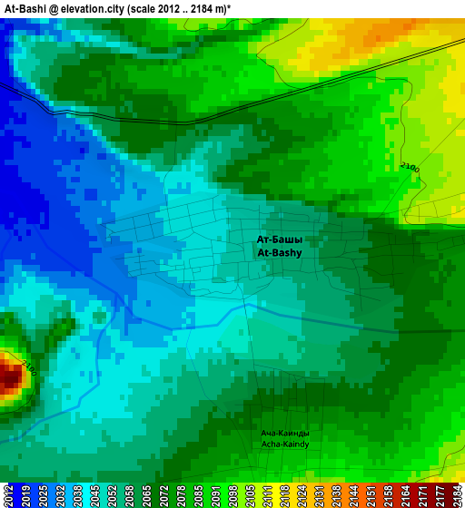
Below is the Elevation map of At-Bashi, which displays elevation range with different colors. Scale of the first map is from 2012 to 2184 m (6601 to 7165 ft) with average elevation of 2064.4 meters (=6773 ft) [note 1]
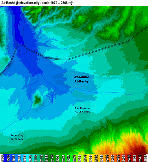
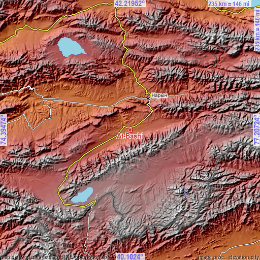
These maps also provides idea of topography and contour of this city, they are displayed at different zoom levels. More info about maps, scale and edge coordinates you can find below images.
| \ | Map #1 | Map #2 | Topo.Map |
| Scale [m] | 2012..2184 m | 1972..2568 m | × |
| Scale [ft] | 6601..7165 ft | 6470..8425 ft | × |
| Average | 2064.4 m = 6773 ft | 2112.4 m = 6930 ft | × |
| Width | 7.36 km = 4.6 mi | 14.71 km = 9.1 mi | 235.4 km = 146.3 mi |
| Height | 7.36 km = 4.6 mi | 14.71 km = 9.1 mi | 235.4 km = 146.3 mi |
| ↑Max Latitude | 41.202582° | 41.235638° | 42.21952° |
| Latitude at center | 41.16951° | 41.16951° | 41.16951° |
| ↓Min Latitude | 41.136421° | 41.103316° | 40.1024° |
| ← Min Longitude | 75.757045° | 75.713099° | 74.39474° |
| Longitude center | 75.80099° | 75.80099° | 75.80099° |
| →Max Longitude | 75.844935° | 75.888881° | 77.20724° |
Nearby cities:
Cities around At-Bashi sort by population:
• Tokmok elevation 824 m
190.5 km,  347°
347°
• Naryn 2048 m
32.9 km,  28°
28°
• Balykchy 1641 m
147 km,  12°
12°
• Kemin 1123 m
180 km,  357°
357°
• Kadzhi-Say 1722 m
157.4 km,  46°
46°
• Kara-Kulja 1384 m
195 km,  252°
252°
• Chuy 820 m
188.4 km, 346°
• Kazarman 1269 m
150.4 km,  280°
280°
• Bokombayevskoye 1810 m
144.7 km,  43°
43°
• Chayek 1653 m
136.1 km,  308°
308°
• Kochkor 1808 m
116.4 km, 358°
• Baetovo 1951 m
71.4 km, 278°
Multilingual:
 En español:
At-Bashi elevación 2047 m.
 En France:
At-Bashi élévation 2047 m.
 Auf Deutsch:
At-Bashi höhe über dem Meeresspiegel ist 2047 m.

Sources and notes:
- [note 1] Map square and city borders are not equal. Map elevation data is calculated only from area inside that square.
- [src 1] Elevation data from geonames database provided with same terms of usage.
- [src 2] The elevation map of At-Bashi is generated using elevation data from NASA's 3 arcsec (90m) resolution SRTM data.
- [src 3] Base (background) map © OpenStreetMap contributors tiles are generated by Geofabrik and OpenTopoMap.
Copyright & License:
This At-Bashi Elevation Map is licensed under CC BY-SA. You may reuse any part from this page, if you give a proper credit by linking to this URL:
 More info on terms of use page.