Tokmok elevation
Tokmok (Chüy), Kyrgyzstan elevation is 824 meters and Tokmok elevation in feet is 2703 ft above sea level [src 1]. Tokmok is a seat of a second-order administrative division (feature code) with elevation that is 372 meters (1220 ft) smaller than average city elevation in Kyrgyzstan.
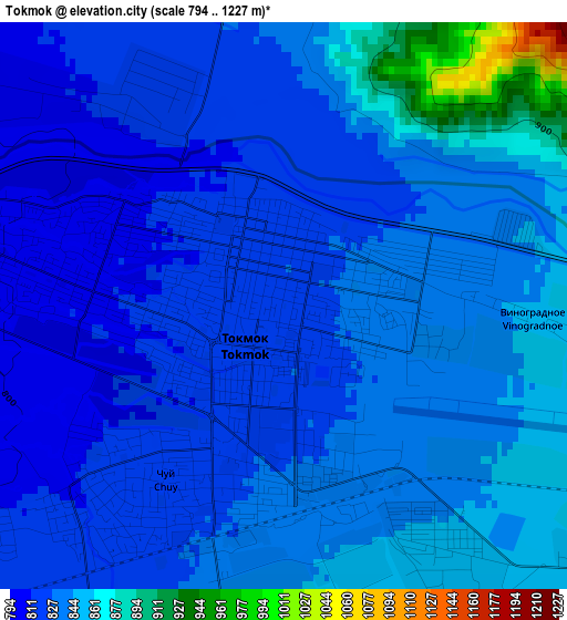
Below is the Elevation map of Tokmok, which displays elevation range with different colors. Scale of the first map is from 794 to 1227 m (2605 to 4026 ft) with average elevation of 835.4 meters (=2741 ft) [note 1]
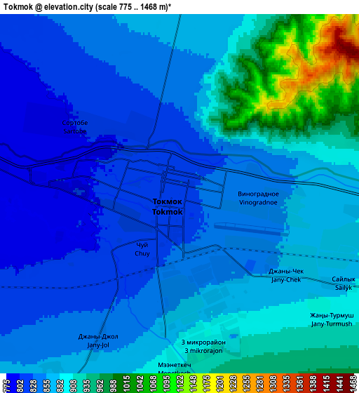
These maps also provides idea of topography and contour of this city, they are displayed at different zoom levels. More info about maps, scale and edge coordinates you can find below images.
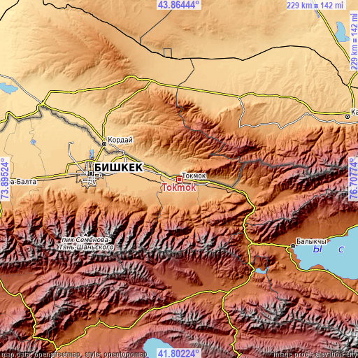
| \ | Map #1 | Map #2 | Topo.Map |
| Scale [m] | 794..1227 m | 775..1468 m | × |
| Scale [ft] | 2605..4026 ft | 2543..4816 ft | × |
| Average | 835.4 m = 2741 ft | 873.5 m = 2866 ft | × |
| Width | 7.17 km = 4.5 mi | 14.33 km = 8.9 mi | 229.3 km = 142.5 mi |
| Height | 7.17 km = 4.5 mi | 14.33 km = 8.9 mi | 229.3 km = 142.5 mi |
| ↑Max Latitude | 42.874154° | 42.906351° | 43.86444° |
| Latitude at center | 42.84194° | 42.84194° | 42.84194° |
| ↓Min Latitude | 42.809709° | 42.777462° | 41.80224° |
| ← Min Longitude | 75.257545° | 75.213599° | 73.89524° |
| Longitude center | 75.30149° | 75.30149° | 75.30149° |
| →Max Longitude | 75.345435° | 75.389381° | 76.70774° |
Nearby cities:
Cities around Tokmok sort by population:
• Bishkek elevation 767 m
58.1 km,  273°
273°
• Kara-Balta 789 m
118.6 km, 268°
• Balykchy 1641 m
83.9 km,  120°
120°
• Kant 743 m
37.1 km,  278°
278°
• Kemin 1123 m
32.4 km,  101°
101°
• Sosnovka 1208 m
117 km,  258°
258°
• Belovodskoye 742 m
97.3 km, 269°
• Sokuluk 742 m
81.4 km, 270°
• Kochkor 1808 m
79 km,  151°
151°
• Lebedinovka 732 m
51 km, 275°
• Ivanovka 745 m
18.4 km,  286°
286°
• Chuy 820 m
2.9 km,  212°
212°
Multilingual:
 En español:
Tokmak elevación 824 m.
 En France:
Tokmok élévation 824 m.


Sources and notes:
- [note 1] Map square and city borders are not equal. Map elevation data is calculated only from area inside that square.
- [src 1] Elevation data from geonames database provided with same terms of usage.
- [src 2] The elevation map of Tokmok is generated using elevation data from NASA's 3 arcsec (90m) resolution SRTM data.
- [src 3] Base (background) map © OpenStreetMap contributors tiles are generated by Geofabrik and OpenTopoMap.
Copyright & License:
This Tokmok Elevation Map is licensed under CC BY-SA. You may reuse any part from this page, if you give a proper credit by linking to this URL:
 More info on terms of use page.