Bishkek elevation
Bishkek, Kyrgyzstan elevation is 767 meters and Bishkek elevation in feet is 2516 ft above sea level [src 1]. Bishkek is a capital of a political entity (feature code) with elevation that is 429 meters (1407 ft) smaller than average city elevation in Kyrgyzstan.
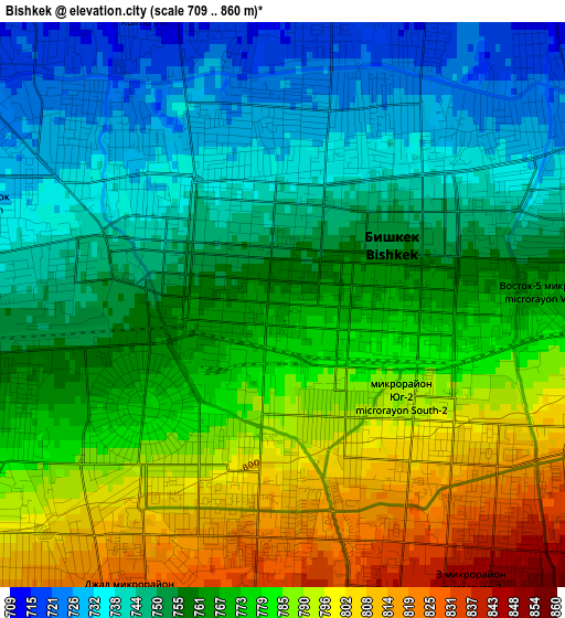
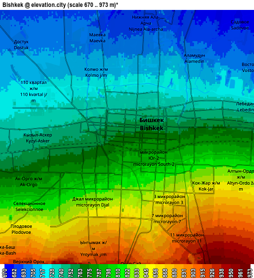
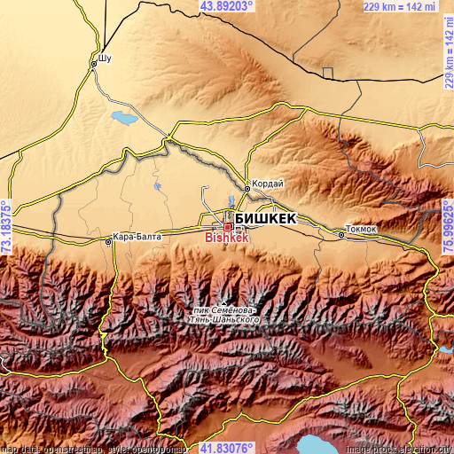
Below is the Elevation map of Bishkek, which displays elevation range with different colors. Scale of the first map is from 709 to 860 m (2326 to 2822 ft) with average elevation of 766.2 meters (=2514 ft) [note 1]
These maps also provides idea of topography and contour of this city, they are displayed at different zoom levels. More info about maps, scale and edge coordinates you can find below images.
| \ | Map #1 | Map #2 | Topo.Map |
| Scale [m] | 709..860 m | 670..973 m | × |
| Scale [ft] | 2326..2822 ft | 2198..3192 ft | × |
| Average | 766.2 m = 2514 ft | 779.2 m = 2556 ft | × |
| Width | 7.16 km = 4.4 mi | 14.32 km = 8.9 mi | 229.2 km = 142.4 mi |
| Height | 7.16 km = 4.4 mi | 14.32 km = 8.9 mi | 229.2 km = 142.4 mi |
| ↑Max Latitude | 42.902199° | 42.934381° | 43.89203° |
| Latitude at center | 42.87° | 42.87° | 42.87° |
| ↓Min Latitude | 42.837784° | 42.805551° | 41.83076° |
| ← Min Longitude | 74.546055° | 74.502109° | 73.18375° |
| Longitude center | 74.59° | 74.59° | 74.59° |
| →Max Longitude | 74.633945° | 74.677891° | 75.99625° |
Nearby cities:
Cities around Bishkek sort by population:
• Tokmok elevation 824 m
58.1 km,  93°
93°
• Kara-Balta 789 m
60.8 km,  264°
264°
• Kant 743 m
21.4 km,  83°
83°
• Kaindy 738 m
74.7 km,  266°
266°
• Kemin 1123 m
90.3 km,  95°
95°
• Sosnovka 1208 m
62.3 km,  245°
245°
• Chayek 1653 m
104.9 km,  183°
183°
• Chuy 820 m
56.7 km, 95°
• Ivanovka 745 m
40.4 km, 87°
• Belovodskoye 742 m
39.5 km, 263°
• Sokuluk 742 m
23.5 km, 265°
• Lebedinovka 732 m
7.4 km, 77°
Multilingual:
 En español:
Biskek elevación 767 m.
 En France:
Bichkek élévation 767 m.
 Auf Deutsch:
Bischkek höhe über dem Meeresspiegel ist 767 m.

Sources and notes:
- [note 1] Map square and city borders are not equal. Map elevation data is calculated only from area inside that square.
- [src 1] Elevation data from geonames database provided with same terms of usage.
- [src 2] The elevation map of Bishkek is generated using elevation data from NASA's 3 arcsec (90m) resolution SRTM data.
- [src 3] Base (background) map © OpenStreetMap contributors tiles are generated by Geofabrik and OpenTopoMap.
Copyright & License:
This Bishkek Elevation Map is licensed under CC BY-SA. You may reuse any part from this page, if you give a proper credit by linking to this URL:
 More info on terms of use page.