Kyzyl-Suu elevation
Kyzyl-Suu (Issyk-Kul), Kyrgyzstan elevation is 1757 meters and Kyzyl-Suu elevation in feet is 5764 ft above sea level [src 1]. Kyzyl-Suu is a seat of a second-order administrative division (feature code) with elevation that is 561 meters (1841 ft) bigger than average city elevation in Kyrgyzstan.
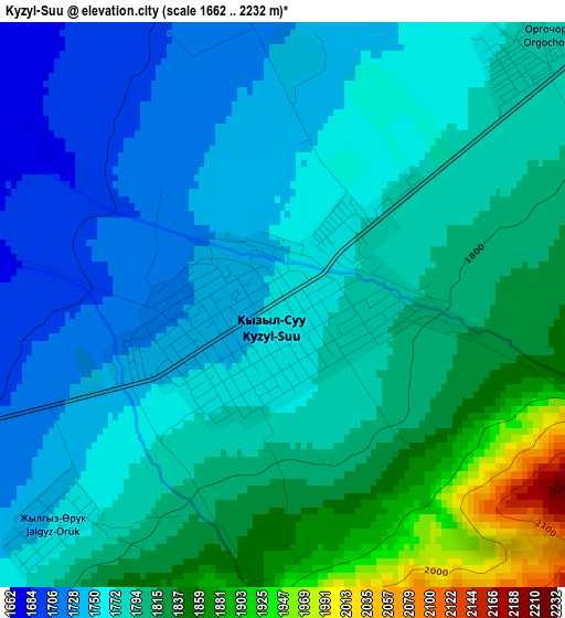
Below is the Elevation map of Kyzyl-Suu, which displays elevation range with different colors. Scale of the first map is from 1662 to 2232 m (5453 to 7323 ft) with average elevation of 1784.4 meters (=5854 ft) [note 1]
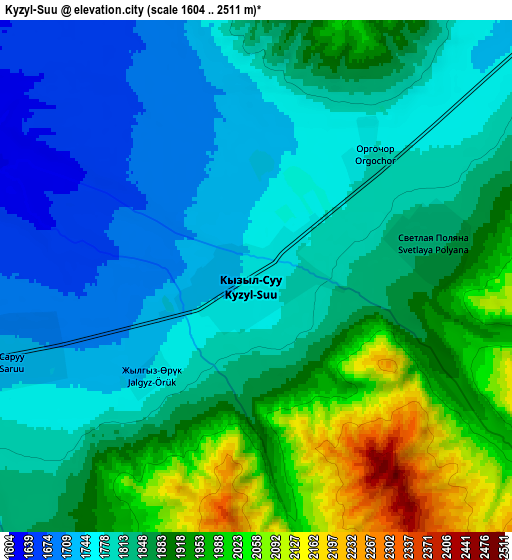
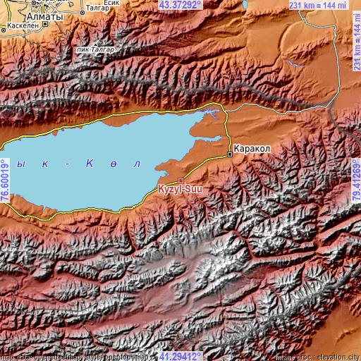
These maps also provides idea of topography and contour of this city, they are displayed at different zoom levels. More info about maps, scale and edge coordinates you can find below images.
| \ | Map #1 | Map #2 | Topo.Map |
| Scale [m] | 1662..2232 m | 1604..2511 m | × |
| Scale [ft] | 5453..7323 ft | 5262..8238 ft | × |
| Average | 1784.4 m = 5854 ft | 1846.2 m = 6057 ft | × |
| Width | 7.22 km = 4.5 mi | 14.45 km = 9 mi | 231.1 km = 143.6 mi |
| Height | 7.22 km = 4.5 mi | 14.45 km = 9 mi | 231.1 km = 143.6 mi |
| ↑Max Latitude | 42.374583° | 42.40704° | 43.37292° |
| Latitude at center | 42.34211° | 42.34211° | 42.34211° |
| ↓Min Latitude | 42.30962° | 42.277113° | 41.29412° |
| ← Min Longitude | 77.962495° | 77.918549° | 76.60019° |
| Longitude center | 78.00644° | 78.00644° | 78.00644° |
| →Max Longitude | 78.050385° | 78.094331° | 79.41269° |
Nearby cities:
Cities around Kyzyl-Suu sort by population:
• Karakol elevation 1751 m
35.8 km,  62°
62°
• Tokmok 824 m
228.3 km,  284°
284°
• Naryn 2048 m
195.3 km,  238°
238°
• Balykchy 1641 m
150 km, 275°
• Cholpon-Ata 1630 m
83.1 km,  294°
294°
• At-Bashi 2047 m
224.6 km,  234°
234°
• Tyup 1629 m
52 km,  34°
34°
• Ak-Suu 1814 m
46.2 km,  67°
67°
• Kemin 1123 m
195.9 km, 284°
• Kadzhi-Say 1722 m
71.7 km,  251°
251°
• Kochkor 1808 m
185.6 km,  265°
265°
• Bokombayevskoye 1810 m
87.1 km, 253°
Multilingual:
 En español:
Kyzyl-Suu elevación 1757 m.
 En France:
Kyzyl-Suu élévation 1757 m.
 Auf Deutsch:
Kyzyl-Suu höhe über dem Meeresspiegel ist 1757 m.

Sources and notes:
- [note 1] Map square and city borders are not equal. Map elevation data is calculated only from area inside that square.
- [src 1] Elevation data from geonames database provided with same terms of usage.
- [src 2] The elevation map of Kyzyl-Suu is generated using elevation data from NASA's 3 arcsec (90m) resolution SRTM data.
- [src 3] Base (background) map © OpenStreetMap contributors tiles are generated by Geofabrik and OpenTopoMap.
Copyright & License:
This Kyzyl-Suu Elevation Map is licensed under CC BY-SA. You may reuse any part from this page, if you give a proper credit by linking to this URL:
 More info on terms of use page.