Ol Kalou elevation
Ol Kalou (Nyandarua), Kenya elevation is 2348 meters and Ol Kalou elevation in feet is 7703 ft above sea level [src 1]. Ol Kalou is a seat of a first-order administrative division (feature code) with elevation that is 1002 meters (3287 ft) bigger than average city elevation in Kenya.
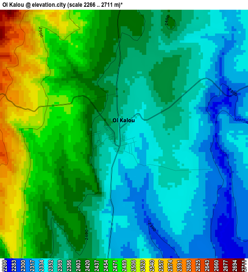
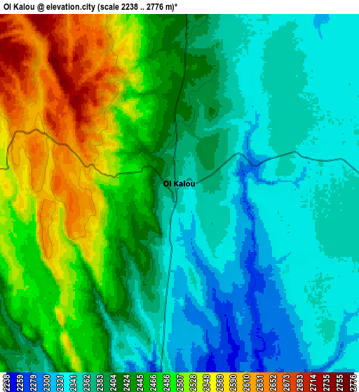
Below is the Elevation map of Ol Kalou, which displays elevation range with different colors. Scale of the first map is from 2266 to 2711 m (7434 to 8894 ft) with average elevation of 2399.5 meters (=7872 ft) [note 1]
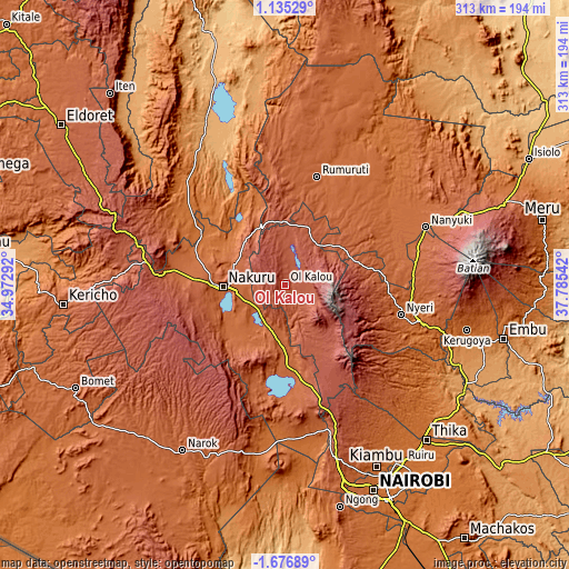
These maps also provides idea of topography and contour of this city, they are displayed at different zoom levels. More info about maps, scale and edge coordinates you can find below images.
| \ | Map #1 | Map #2 | Topo.Map |
| Scale [m] | 2266..2711 m | 2238..2776 m | × |
| Scale [ft] | 7434..8894 ft | 7343..9108 ft | × |
| Average | 2399.5 m = 7872 ft | 2423.9 m = 7952 ft | × |
| Width | 9.77 km = 6.1 mi | 19.54 km = 12.1 mi | 312.7 km = 194.3 mi |
| Height | 9.77 km = 6.1 mi | 19.54 km = 12.1 mi | 312.7 km = 194.3 mi |
| ↑Max Latitude | -0.226935° | -0.18299° | 1.13529° |
| Latitude at center | -0.27088° | -0.27088° | -0.27088° |
| ↓Min Latitude | -0.314825° | -0.358769° | -1.67689° |
| ← Min Longitude | 36.335225° | 36.291279° | 34.97292° |
| Longitude center | 36.37917° | 36.37917° | 36.37917° |
| →Max Longitude | 36.423115° | 36.467061° | 37.78542° |
Nearby cities:
Cities around Ol Kalou sort by population:
• Nakuru elevation 1857 m
34.4 km,  263°
263°
• Nyeri 1812 m
65.3 km,  104°
104°
• Naivasha 2084 m
49.6 km,  173°
173°
• Nyahururu 2335 m
34.4 km,  357°
357°
• Rongai 1874 m
58.4 km,  280°
280°
• Molo 2514 m
72 km,  271°
271°
• Eldama Ravine 2047 m
80.9 km,  296°
296°
• Naro Moru 2024 m
72 km,  80°
80°
• Kijabe 2050 m
76.7 km,  163°
163°
• Rumuruti 1846 m
62.9 km,  16°
16°
• Othaya 1881 m
68.7 km,  116°
116°
• Kangema 1770 m
79.8 km,  125°
125°
Multilingual:
 En español:
Ol Kalou elevación 2348 m.
 En France:
Ol Kalou élévation 2348 m.
 Auf Deutsch:
Ol Kalou höhe über dem Meeresspiegel ist 2348 m.

Sources and notes:
- [note 1] Map square and city borders are not equal. Map elevation data is calculated only from area inside that square.
- [src 1] Elevation data from geonames database provided with same terms of usage.
- [src 2] The elevation map of Ol Kalou is generated using elevation data from NASA's 3 arcsec (90m) resolution SRTM data.
- [src 3] Base (background) map © OpenStreetMap contributors tiles are generated by Geofabrik and OpenTopoMap.
Copyright & License:
This Ol Kalou Elevation Map is licensed under CC BY-SA. You may reuse any part from this page, if you give a proper credit by linking to this URL:
 More info on terms of use page.