Naro Moru elevation
Naro Moru (Nyeri), Kenya elevation is 2024 meters and Naro Moru elevation in feet is 6640 ft above sea level [src 1]. Naro Moru is a populated place (feature code) with elevation that is 678 meters (2224 ft) bigger than average city elevation in Kenya.
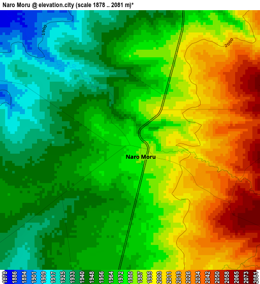
Below is the Elevation map of Naro Moru, which displays elevation range with different colors. Scale of the first map is from 1878 to 2081 m (6161 to 6827 ft) with average elevation of 1972.2 meters (=6470 ft) [note 1]
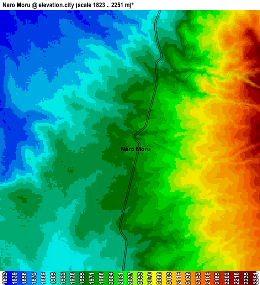
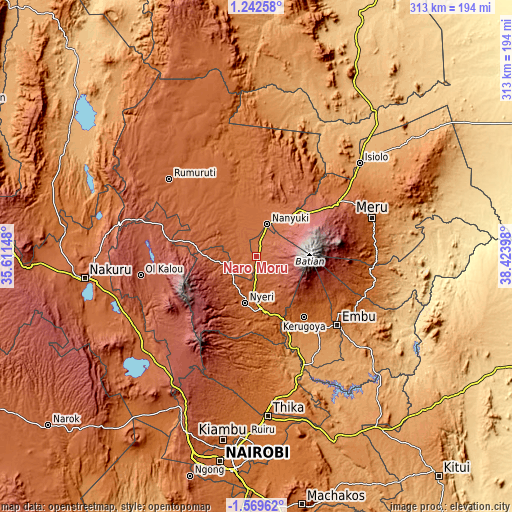
These maps also provides idea of topography and contour of this city, they are displayed at different zoom levels. More info about maps, scale and edge coordinates you can find below images.
| \ | Map #1 | Map #2 | Topo.Map |
| Scale [m] | 1878..2081 m | 1823..2251 m | × |
| Scale [ft] | 6161..6827 ft | 5981..7385 ft | × |
| Average | 1972.2 m = 6470 ft | 1977.8 m = 6489 ft | × |
| Width | 9.77 km = 6.1 mi | 19.55 km = 12.1 mi | 312.7 km = 194.3 mi |
| Height | 9.77 km = 6.1 mi | 19.54 km = 12.1 mi | 312.7 km = 194.3 mi |
| ↑Max Latitude | -0.119625° | -0.07568° | 1.24258° |
| Latitude at center | -0.16357° | -0.16357° | -0.16357° |
| ↓Min Latitude | -0.207515° | -0.25146° | -1.56962° |
| ← Min Longitude | 36.973785° | 36.929839° | 35.61148° |
| Longitude center | 37.01773° | 37.01773° | 37.01773° |
| →Max Longitude | 37.061675° | 37.105621° | 38.42398° |
Nearby cities:
Cities around Naro Moru sort by population:
• Nyeri elevation 1812 m
29.6 km,  195°
195°
• Ol Kalou 2348 m
72 km,  260°
260°
• Nanyuki 2001 m
19.9 km,  18°
18°
• Embu 1294 m
64.3 km,  130°
130°
• Karuri 1211 m
62.4 km,  162°
162°
• Kerugoya 1548 m
47.4 km,  141°
141°
• Murang’a 1318 m
63.8 km,  166°
166°
• Maragua 1360 m
71.5 km, 169°
• Rumuruti 1846 m
72.1 km,  312°
312°
• Othaya 1881 m
43.6 km,  192°
192°
• Kangema 1770 m
58.3 km, 185°
• Sagana 1201 m
60 km, 159°
Multilingual:
 En español:
Naro Moru elevación 2024 m.
 En France:
Naro Moru élévation 2024 m.
 Auf Deutsch:
Naro Moru höhe über dem Meeresspiegel ist 2024 m.

Sources and notes:
- [note 1] Map square and city borders are not equal. Map elevation data is calculated only from area inside that square.
- [src 1] Elevation data from geonames database provided with same terms of usage.
- [src 2] The elevation map of Naro Moru is generated using elevation data from NASA's 3 arcsec (90m) resolution SRTM data.
- [src 3] Base (background) map © OpenStreetMap contributors tiles are generated by Geofabrik and OpenTopoMap.
Copyright & License:
This Naro Moru Elevation Map is licensed under CC BY-SA. You may reuse any part from this page, if you give a proper credit by linking to this URL:
 More info on terms of use page.