Nyeri elevation
Nyeri, Kenya elevation is 1812 meters and Nyeri elevation in feet is 5945 ft above sea level [src 1]. Nyeri is a seat of a first-order administrative division (feature code) with elevation that is 466 meters (1529 ft) bigger than average city elevation in Kenya.
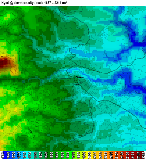
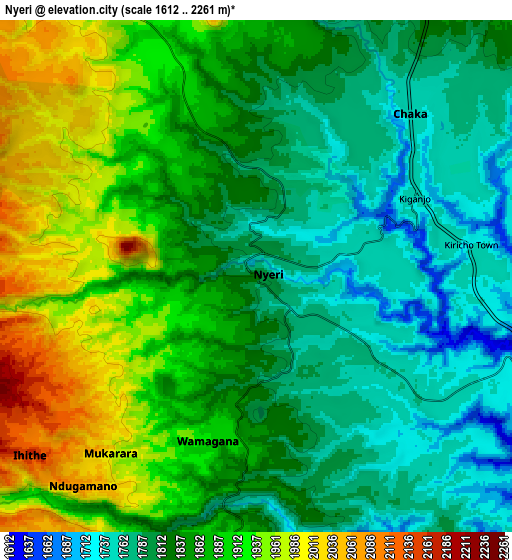
Below is the Elevation map of Nyeri, which displays elevation range with different colors. Scale of the first map is from 1657 to 2214 m (5436 to 7264 ft) with average elevation of 1814.4 meters (=5953 ft) [note 1]
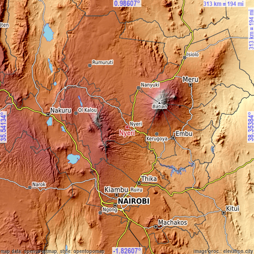
These maps also provides idea of topography and contour of this city, they are displayed at different zoom levels. More info about maps, scale and edge coordinates you can find below images.
| \ | Map #1 | Map #2 | Topo.Map |
| Scale [m] | 1657..2214 m | 1612..2261 m | × |
| Scale [ft] | 5436..7264 ft | 5289..7418 ft | × |
| Average | 1814.4 m = 5953 ft | 1853.6 m = 6081 ft | × |
| Width | 9.77 km = 6.1 mi | 19.54 km = 12.1 mi | 312.7 km = 194.3 mi |
| Height | 9.77 km = 6.1 mi | 19.54 km = 12.1 mi | 312.7 km = 194.3 mi |
| ↑Max Latitude | -0.376186° | -0.332241° | 0.98607° |
| Latitude at center | -0.42013° | -0.42013° | -0.42013° |
| ↓Min Latitude | -0.464074° | -0.508018° | -1.82607° |
| ← Min Longitude | 36.903645° | 36.859699° | 35.54134° |
| Longitude center | 36.94759° | 36.94759° | 36.94759° |
| →Max Longitude | 36.991535° | 37.035481° | 38.35384° |
Nearby cities:
Cities around Nyeri sort by population:
• Ol Kalou elevation 2348 m
65.3 km,  284°
284°
• Naivasha 2084 m
65.9 km,  240°
240°
• Nanyuki 2001 m
49.4 km,  16°
16°
• Embu 1294 m
58.2 km,  103°
103°
• Karuri 1211 m
40.7 km,  139°
139°
• Kerugoya 1548 m
38 km, 103°
• Murang’a 1318 m
40.5 km,  145°
145°
• Naro Moru 2024 m
29.6 km, 15°
• Maragua 1360 m
46.6 km, 153°
• Othaya 1881 m
14.2 km,  187°
187°
• Kangema 1770 m
29.6 km,  176°
176°
• Sagana 1201 m
40 km,  133°
133°
Multilingual:
 En español:
Nyeri elevación 1812 m.
 En France:
Nyeri élévation 1812 m.


Sources and notes:
- [note 1] Map square and city borders are not equal. Map elevation data is calculated only from area inside that square.
- [src 1] Elevation data from geonames database provided with same terms of usage.
- [src 2] The elevation map of Nyeri is generated using elevation data from NASA's 3 arcsec (90m) resolution SRTM data.
- [src 3] Base (background) map © OpenStreetMap contributors tiles are generated by Geofabrik and OpenTopoMap.
Copyright & License:
This Nyeri Elevation Map is licensed under CC BY-SA. You may reuse any part from this page, if you give a proper credit by linking to this URL:
 More info on terms of use page.