Iten elevation
Iten (Elegeyo-Marakwet), Kenya elevation is 2355 meters and Iten elevation in feet is 7726 ft above sea level [src 1]. Iten is a seat of a first-order administrative division (feature code) with elevation that is 1009 meters (3310 ft) bigger than average city elevation in Kenya.
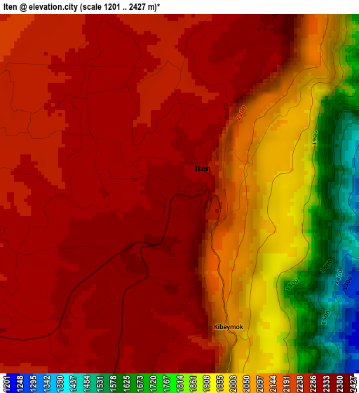
Below is the Elevation map of Iten, which displays elevation range with different colors. Scale of the first map is from 1201 to 2427 m (3940 to 7963 ft) with average elevation of 2156.1 meters (=7074 ft) [note 1]
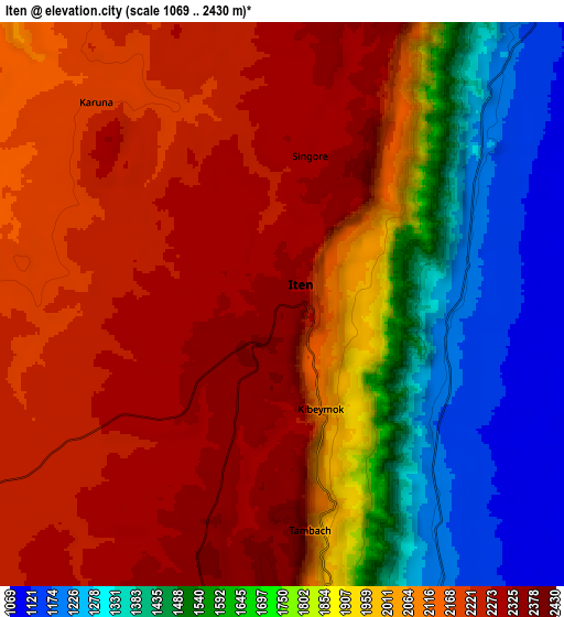
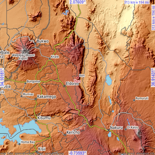
These maps also provides idea of topography and contour of this city, they are displayed at different zoom levels. More info about maps, scale and edge coordinates you can find below images.
| \ | Map #1 | Map #2 | Topo.Map |
| Scale [m] | 1201..2427 m | 1069..2430 m | × |
| Scale [ft] | 3940..7963 ft | 3507..7972 ft | × |
| Average | 2156.1 m = 7074 ft | 1938.2 m = 6359 ft | × |
| Width | 9.77 km = 6.1 mi | 19.54 km = 12.1 mi | 312.7 km = 194.3 mi |
| Height | 9.77 km = 6.1 mi | 19.54 km = 12.1 mi | 312.7 km = 194.3 mi |
| ↑Max Latitude | 0.714222° | 0.758164° | 2.07609° |
| Latitude at center | 0.67028° | 0.67028° | 0.67028° |
| ↓Min Latitude | 0.626338° | 0.582395° | -0.73593° |
| ← Min Longitude | 35.464115° | 35.420169° | 34.10181° |
| Longitude center | 35.50806° | 35.50806° | 35.50806° |
| →Max Longitude | 35.552005° | 35.595951° | 36.91431° |
Nearby cities:
Cities around Iten sort by population:
• Eldoret elevation 2095 m
31.3 km,  237°
237°
• Kitale 1900 m
67.7 km,  304°
304°
• Kapenguria 2020 m
77 km,  325°
325°
• Kabarnet 2048 m
32.8 km,  127°
127°
• Webuye 1502 m
82.3 km,  264°
264°
• Eldama Ravine 2047 m
72.9 km,  160°
160°
• Kapsowar 2058 m
34.8 km,  9°
9°
• Baringo 1090 m
55.8 km,  113°
113°
• Londiani 2291 m
93.4 km,  174°
174°
• Nandi Hills 1987 m
72.6 km,  209°
209°
• Kapsabet 1998 m
68.5 km,  220°
220°
• Chepareria 1723 m
78.4 km, 334°
Multilingual:
 En español:
Iten elevación 2355 m.
 En France:
Iten élévation 2355 m.


Sources and notes:
- [note 1] Map square and city borders are not equal. Map elevation data is calculated only from area inside that square.
- [src 1] Elevation data from geonames database provided with same terms of usage.
- [src 2] The elevation map of Iten is generated using elevation data from NASA's 3 arcsec (90m) resolution SRTM data.
- [src 3] Base (background) map © OpenStreetMap contributors tiles are generated by Geofabrik and OpenTopoMap.
Copyright & License:
This Iten Elevation Map is licensed under CC BY-SA. You may reuse any part from this page, if you give a proper credit by linking to this URL:
 More info on terms of use page.