Kapenguria elevation
Kapenguria (West Pokot), Kenya elevation is 2020 meters and Kapenguria elevation in feet is 6627 ft above sea level [src 1]. Kapenguria is a seat of a first-order administrative division (feature code) with elevation that is 674 meters (2211 ft) bigger than average city elevation in Kenya.
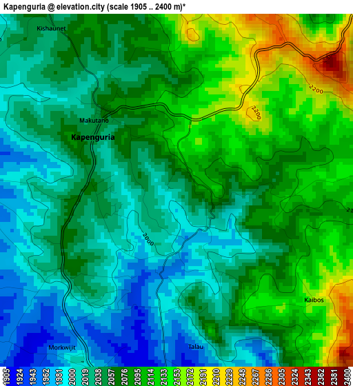
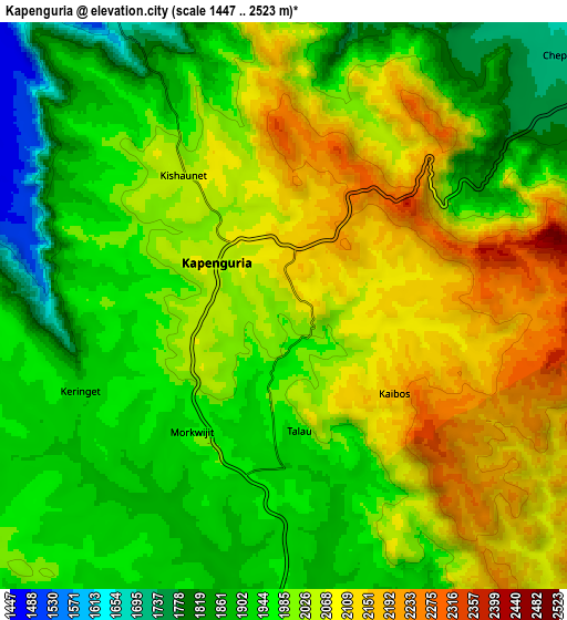
Below is the Elevation map of Kapenguria, which displays elevation range with different colors. Scale of the first map is from 1905 to 2400 m (6250 to 7874 ft) with average elevation of 2064 meters (=6772 ft) [note 1]
These maps also provides idea of topography and contour of this city, they are displayed at different zoom levels. More info about maps, scale and edge coordinates you can find below images.
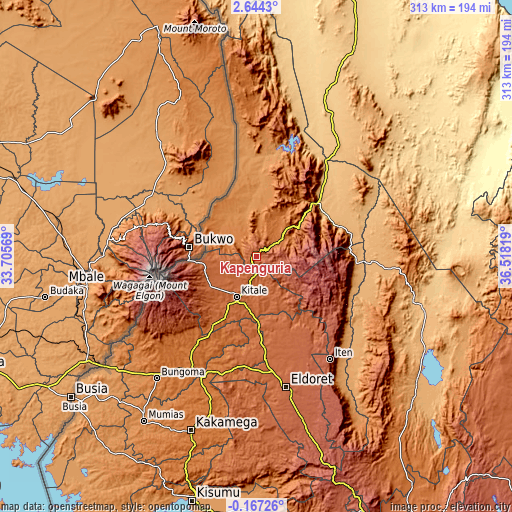
| \ | Map #1 | Map #2 | Topo.Map |
| Scale [m] | 1905..2400 m | 1447..2523 m | × |
| Scale [ft] | 6250..7874 ft | 4747..8278 ft | × |
| Average | 2064 m = 6772 ft | 1999.7 m = 6561 ft | × |
| Width | 9.77 km = 6.1 mi | 19.54 km = 12.1 mi | 312.6 km = 194.2 mi |
| Height | 9.77 km = 6.1 mi | 19.54 km = 12.1 mi | 312.6 km = 194.2 mi |
| ↑Max Latitude | 1.282825° | 1.326759° | 2.6443° |
| Latitude at center | 1.23889° | 1.23889° | 1.23889° |
| ↓Min Latitude | 1.194955° | 1.151018° | -0.16726° |
| ← Min Longitude | 35.067995° | 35.024049° | 33.70569° |
| Longitude center | 35.11194° | 35.11194° | 35.11194° |
| →Max Longitude | 35.155885° | 35.199831° | 36.51819° |
Nearby cities:
Cities around Kapenguria sort by population:
• Eldoret elevation 2095 m
81.8 km,  167°
167°
• Kitale 1900 m
27.5 km,  205°
205°
• Kakamega 1563 m
113.4 km,  200°
200°
• Bungoma 1427 m
96.9 km,  219°
219°
• Iten 2355 m
77 km,  145°
145°
• Kabarnet 2048 m
108.7 km,  139°
139°
• Webuye 1502 m
80.5 km, 208°
• Kapsowar 2058 m
57.5 km,  120°
120°
• Malaba 1193 m
114.1 km,  233°
233°
• Malikisi 1343 m
99 km, 230°
• Chepareria 1723 m
12.6 km,  53°
53°
• Bungoma 1452 m
93.6 km, 218°
Multilingual:
 En español:
Kapenguria elevación 2020 m.
 En France:
Kapenguria élévation 2020 m.
 Auf Deutsch:
Kapenguria höhe über dem Meeresspiegel ist 2020 m.

Sources and notes:
- [note 1] Map square and city borders are not equal. Map elevation data is calculated only from area inside that square.
- [src 1] Elevation data from geonames database provided with same terms of usage.
- [src 2] The elevation map of Kapenguria is generated using elevation data from NASA's 3 arcsec (90m) resolution SRTM data.
- [src 3] Base (background) map © OpenStreetMap contributors tiles are generated by Geofabrik and OpenTopoMap.
Copyright & License:
This Kapenguria Elevation Map is licensed under CC BY-SA. You may reuse any part from this page, if you give a proper credit by linking to this URL:
 More info on terms of use page.