Londiani elevation
Londiani (Kericho), Kenya elevation is 2291 meters and Londiani elevation in feet is 7516 ft above sea level [src 1]. Londiani is a populated place (feature code) with elevation that is 945 meters (3100 ft) bigger than average city elevation in Kenya.
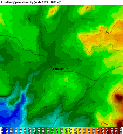
Below is the Elevation map of Londiani, which displays elevation range with different colors. Scale of the first map is from 2113 to 2601 m (6932 to 8533 ft) with average elevation of 2313.9 meters (=7592 ft) [note 1]
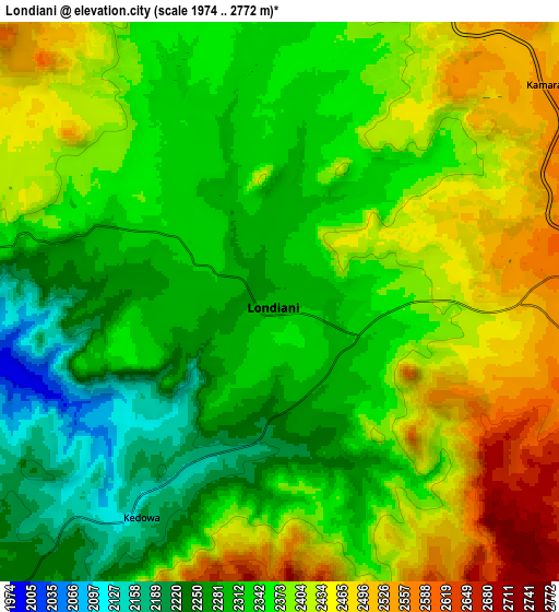
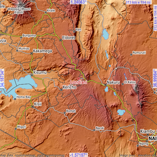
These maps also provides idea of topography and contour of this city, they are displayed at different zoom levels. More info about maps, scale and edge coordinates you can find below images.
| \ | Map #1 | Map #2 | Topo.Map |
| Scale [m] | 2113..2601 m | 1974..2772 m | × |
| Scale [ft] | 6932..8533 ft | 6476..9094 ft | × |
| Average | 2313.9 m = 7592 ft | 2364.5 m = 7758 ft | × |
| Width | 9.77 km = 6.1 mi | 19.55 km = 12.1 mi | 312.7 km = 194.3 mi |
| Height | 9.77 km = 6.1 mi | 19.54 km = 12.1 mi | 312.7 km = 194.3 mi |
| ↑Max Latitude | -0.121575° | -0.07763° | 1.24063° |
| Latitude at center | -0.16552° | -0.16552° | -0.16552° |
| ↓Min Latitude | -0.209465° | -0.25341° | -1.57157° |
| ← Min Longitude | 35.549645° | 35.505699° | 34.18734° |
| Longitude center | 35.59359° | 35.59359° | 35.59359° |
| →Max Longitude | 35.637535° | 35.681481° | 36.99984° |
Nearby cities:
Cities around Londiani sort by population:
• Nakuru elevation 1857 m
55.5 km,  106°
106°
• Kericho 2002 m
41.2 km,  236°
236°
• Rongai 1874 m
30 km,  91°
91°
• Molo 2514 m
17.9 km,  120°
120°
• Kabarnet 2048 m
75 km,  12°
12°
• Muhoroni 1462 m
44.2 km,  271°
271°
• Eldama Ravine 2047 m
28.4 km,  31°
31°
• Sotik Post 1959 m
74 km,  202°
202°
• Nandi Hills 1987 m
54.5 km,  303°
303°
• Kapsabet 1998 m
68.1 km,  307°
307°
• Litein 1940 m
64.5 km,  224°
224°
• Kipkelion 2041 m
14.5 km,  254°
254°
Multilingual:
 En español:
Londiani elevación 2291 m.
 En France:
Londiani élévation 2291 m.
 Auf Deutsch:
Londiani höhe über dem Meeresspiegel ist 2291 m.

Sources and notes:
- [note 1] Map square and city borders are not equal. Map elevation data is calculated only from area inside that square.
- [src 1] Elevation data from geonames database provided with same terms of usage.
- [src 2] The elevation map of Londiani is generated using elevation data from NASA's 3 arcsec (90m) resolution SRTM data.
- [src 3] Base (background) map © OpenStreetMap contributors tiles are generated by Geofabrik and OpenTopoMap.
Copyright & License:
This Londiani Elevation Map is licensed under CC BY-SA. You may reuse any part from this page, if you give a proper credit by linking to this URL:
 More info on terms of use page.