Kericho elevation
Kericho, Kenya elevation is 2002 meters and Kericho elevation in feet is 6568 ft above sea level [src 1]. Kericho is a seat of a first-order administrative division (feature code) with elevation that is 656 meters (2152 ft) bigger than average city elevation in Kenya.
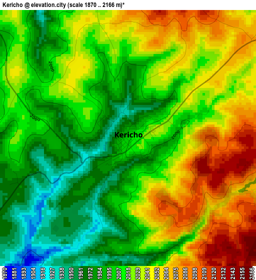
Below is the Elevation map of Kericho, which displays elevation range with different colors. Scale of the first map is from 1870 to 2166 m (6135 to 7106 ft) with average elevation of 2018.1 meters (=6621 ft) [note 1]
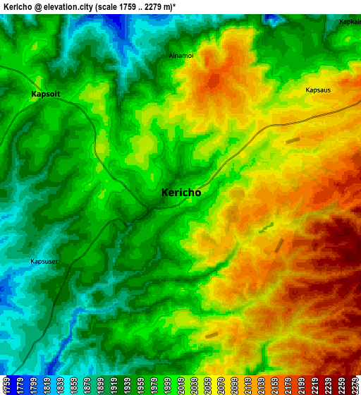
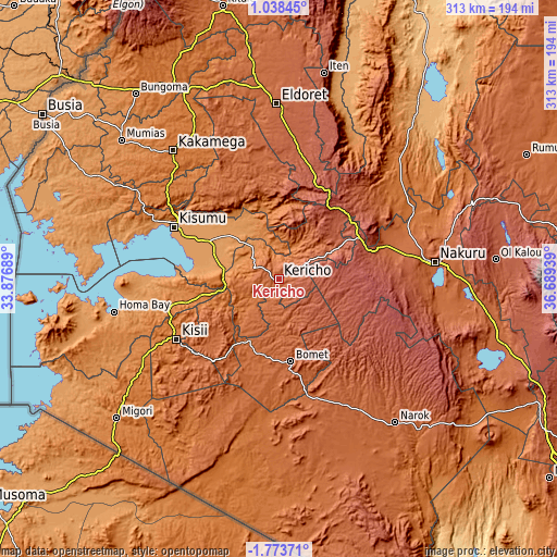
These maps also provides idea of topography and contour of this city, they are displayed at different zoom levels. More info about maps, scale and edge coordinates you can find below images.
| \ | Map #1 | Map #2 | Topo.Map |
| Scale [m] | 1870..2166 m | 1759..2279 m | × |
| Scale [ft] | 6135..7106 ft | 5771..7477 ft | × |
| Average | 2018.1 m = 6621 ft | 2009.9 m = 6594 ft | × |
| Width | 9.77 km = 6.1 mi | 19.54 km = 12.1 mi | 312.7 km = 194.3 mi |
| Height | 9.77 km = 6.1 mi | 19.54 km = 12.1 mi | 312.7 km = 194.3 mi |
| ↑Max Latitude | -0.323795° | -0.279851° | 1.03845° |
| Latitude at center | -0.36774° | -0.36774° | -0.36774° |
| ↓Min Latitude | -0.411684° | -0.455628° | -1.77371° |
| ← Min Longitude | 35.239195° | 35.195249° | 33.87689° |
| Longitude center | 35.28314° | 35.28314° | 35.28314° |
| →Max Longitude | 35.327085° | 35.371031° | 36.68939° |
Nearby cities:
Cities around Kericho sort by population:
• Molo elevation 2514 m
51.6 km,  75°
75°
• Muhoroni 1462 m
25.2 km,  337°
337°
• Oyugis 1437 m
63.4 km,  255°
255°
• Nyamira 2000 m
44.3 km,  240°
240°
• Ahero 1153 m
45.9 km,  298°
298°
• Sotik Post 1959 m
46.4 km,  171°
171°
• Londiani 2291 m
41.2 km,  56°
56°
• Nandi Hills 1987 m
53.6 km,  348°
348°
• Keroka 2126 m
58.8 km,  219°
219°
• Litein 1940 m
26 km,  203°
203°
• Kipkelion 2041 m
27.7 km,  47°
47°
• Sotik 1779 m
40.7 km,  208°
208°
Multilingual:
 En español:
Kericho elevación 2002 m.
 En France:
Kericho élévation 2002 m.
 Auf Deutsch:
Kericho höhe über dem Meeresspiegel ist 2002 m.

Sources and notes:
- [note 1] Map square and city borders are not equal. Map elevation data is calculated only from area inside that square.
- [src 1] Elevation data from geonames database provided with same terms of usage.
- [src 2] The elevation map of Kericho is generated using elevation data from NASA's 3 arcsec (90m) resolution SRTM data.
- [src 3] Base (background) map © OpenStreetMap contributors tiles are generated by Geofabrik and OpenTopoMap.
Copyright & License:
This Kericho Elevation Map is licensed under CC BY-SA. You may reuse any part from this page, if you give a proper credit by linking to this URL:
 More info on terms of use page.