Ahero elevation
Ahero (Kisumu), Kenya elevation is 1153 meters and Ahero elevation in feet is 3783 ft above sea level [src 1]. Ahero is a populated place (feature code) with elevation that is 193 meters (633 ft) smaller than average city elevation in Kenya.
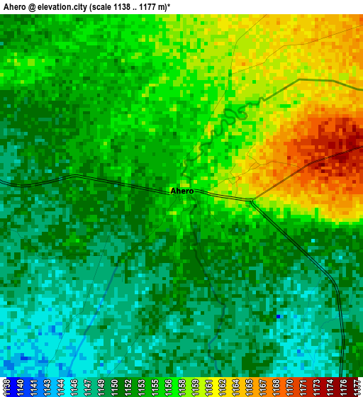
Below is the Elevation map of Ahero, which displays elevation range with different colors. Scale of the first map is from 1138 to 1177 m (3734 to 3862 ft) with average elevation of 1153.4 meters (=3784 ft) [note 1]
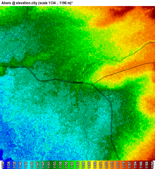
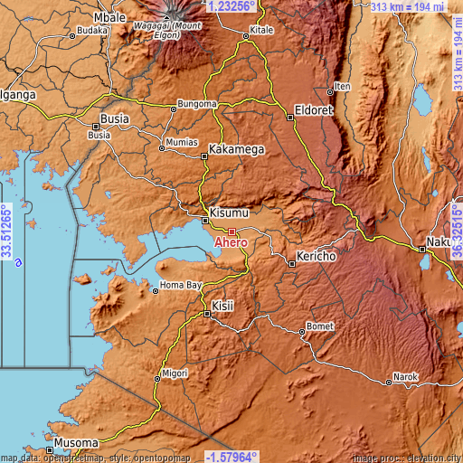
These maps also provides idea of topography and contour of this city, they are displayed at different zoom levels. More info about maps, scale and edge coordinates you can find below images.
| \ | Map #1 | Map #2 | Topo.Map |
| Scale [m] | 1138..1177 m | 1134..1190 m | × |
| Scale [ft] | 3734..3862 ft | 3720..3904 ft | × |
| Average | 1153.4 m = 3784 ft | 1155.3 m = 3790 ft | × |
| Width | 9.77 km = 6.1 mi | 19.55 km = 12.1 mi | 312.7 km = 194.3 mi |
| Height | 9.77 km = 6.1 mi | 19.54 km = 12.1 mi | 312.7 km = 194.3 mi |
| ↑Max Latitude | -0.129645° | -0.0857° | 1.23256° |
| Latitude at center | -0.17359° | -0.17359° | -0.17359° |
| ↓Min Latitude | -0.217535° | -0.26148° | -1.57964° |
| ← Min Longitude | 34.874955° | 34.831009° | 33.51265° |
| Longitude center | 34.9189° | 34.9189° | 34.9189° |
| →Max Longitude | 34.962845° | 35.006791° | 36.32515° |
Nearby cities:
Cities around Ahero sort by population:
• Kisumu elevation 1174 m
19.2 km,  294°
294°
• Kakamega 1563 m
54.2 km,  340°
340°
• Kericho 2002 m
45.9 km,  118°
118°
• Kisii 1686 m
59 km,  196°
196°
• Muhoroni 1462 m
30.9 km,  86°
86°
• Oyugis 1437 m
42.8 km,  209°
209°
• Nyamira 2000 m
43.4 km,  177°
177°
• Nandi Hills 1987 m
42.7 km,  43°
43°
• Kapsabet 1998 m
46.8 km,  26°
26°
• Litein 1940 m
54.5 km,  146°
146°
• Yala 1371 m
52 km,  304°
304°
• Mbale 1628 m
35.9 km,  322°
322°
Multilingual:
 En español:
Ahero elevación 1153 m.
 En France:
Ahero élévation 1153 m.


Sources and notes:
- [note 1] Map square and city borders are not equal. Map elevation data is calculated only from area inside that square.
- [src 1] Elevation data from geonames database provided with same terms of usage.
- [src 2] The elevation map of Ahero is generated using elevation data from NASA's 3 arcsec (90m) resolution SRTM data.
- [src 3] Base (background) map © OpenStreetMap contributors tiles are generated by Geofabrik and OpenTopoMap.
Copyright & License:
This Ahero Elevation Map is licensed under CC BY-SA. You may reuse any part from this page, if you give a proper credit by linking to this URL:
 More info on terms of use page.